County Kilkenny is a county in Ireland. It is in the province of Leinster and is part of the Southern Region. It is named after the city of Kilkenny. Kilkenny County Council is the local authority for the county. At the 2022 census the population of the county was 103,685. The county was based on the historic Gaelic kingdom of Ossory (Osraighe), which was coterminous with the Diocese of Ossory.

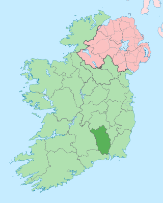
County Carlow is a county located in the Southern Region of Ireland, within the province of Leinster. Carlow is the second smallest and the third least populous of Ireland's 32 traditional counties. Carlow County Council is the governing local authority.

Bagenalstown, officially named Muine Bheag, is a small town on the River Barrow in County Carlow, Ireland.

Banna Strand, also known as Banna Beach, is a beach in North Kerry, Ireland. It is an Atlantic Ocean beach extending from the Smallrock and Blackrock in the North to Carrahane at its southern edge. It is around 12 kilometres (7 mi) north west of Tralee. It features shifting sand dunes along its entire length which rise up to 12 metres (40 ft). Carrahane lagoon on the south end, famous for migrating birds and the Roger Casement landing. The mountains of the Dingle Peninsula can be seen on the south west horizon. Many residents from Tralee make a trip to Banna Strand on the warmest summer days.

Rathbeagh is a townland and hill on the River Nore in the parish of Lisdowney near Ballyragget, County Kilkenny, Ireland. The Irish language name is Rath Beithigh, meaning "rath (ringfort) of the birch trees". It is located in an ancient valley once called Mágh Airgid Rois.
Listowel Castle, located near the town of Listowel, County Kerry in Ireland, was built in the 15th century. The castle is a noted example of Anglo-Norman architecture in County Kerry, and has been the subject of several restoration projects. It is now protected as a national monument, and is open to the public for tours on a daily basis.

Mount Leinster is a 794-metre-high (2,605 ft) mountain in the Republic of Ireland. It straddles the border between Counties Carlow and Wexford, in the province of Leinster. It is the fifth-highest mountain in Leinster after Lugnaquilla 925 metres (3,035 ft), Mullaghcleevaun 849 metres (2,785 ft), Tonelagee 817 metres (2,680 ft), and Cloghernagh 800 metres (2,600 ft), and the highest of the Blackstairs Mountains. A 2RN transmission site tops the peak with a mast height of 122 metres (400 ft).

Carlow Castle is located near the River Barrow in County Carlow, Ireland. It was built between 1207 and 1213, and is a National Monument of Ireland.

Ballymoon Castle is a National Monument situated 2 miles (3 km) east of Bagenalstown, County Carlow, Ireland. The castle is thought to date from the 13th century.

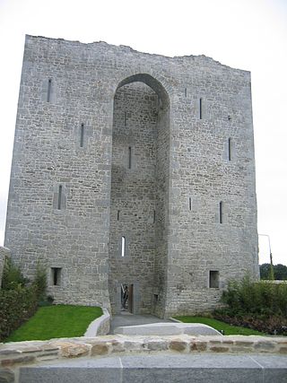
Leighlinbridge Castle, also called Black Castle, is in the village of Leighlinbridge, County Carlow, Ireland, on the River Barrow.
Purt Castle or Port Castle is a ruined Geraldine castle near Abbeyfeale, County Limerick, Ireland. The castle is known variously as 'Purt Castle', 'Port Castle', or 'Portrinard Castle' in sources.

Lisnavagh Estate is an estate house which lies outside the village of Rathvilly in County Carlow, Ireland. Lisnavagh is the family seat of the McClintock-Bunbury family, Barons Rathdonnell. A plaque in the present house states that the original house at Lisnavagh was built by William Bunbury in 1696. A map from the 1840 Ordnance Survey shows this in the parklands below the current house, with some modest farm buildings close by. The 1840 map also shows "Foundations of House" to the northwest, near the top of the hill, which is where a new house was planned but never completed. The new house was ultimately built nearer to the old house.

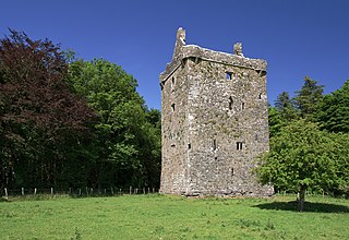
Huntington Castle, also known as Clonegal Castle, is a castle in Clonegal, County Carlow, Ireland, built in 1625.
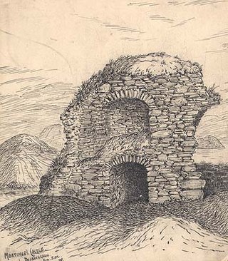
Mortimer's Castle is a castle and National Monument located in County Westmeath, Ireland.
Feartagar Castle, also called Jennings Castle, is a tower house and National Monument located in County Galway, Ireland.

The Lismore Crozier is an Irish Insular-type crozier dated to between 1100 and 1113 AD. It consists of a wooden tubular staff lined with copper-alloy plates; embellished with silver, gold, niello and glass; and capped by a crook with a decorative openwork crest. The inscriptions on the upper knope record that it was built by "Nechtain the craftsman" and commissioned by Niall mac Meic Aeducain, bishop of Lismore. This makes it the only extant insular crozier to be inscribed, and the only one whose date of origin can be closely approximated. It was rediscovered in 1814, along with the 15th-century Book of Lismore, in a walled-up doorway in Lismore Castle, County Waterford, where it was probably hidden in the late Middle Ages during a period of either religious persecution or raids.

Mountgarret is a townland in New Ross, County Wexford, Ireland. It is known for the ruins of a medieval tower house that was built by the Bishop of Ferns in 1408.

Tomás "Tom" de PaorFRIAI Int FRIBA is an Irish architect and member of Aosdána.

The monastic site in St Mullin's, County Carlow, Ireland, is an early medieval ecclesiastical site.

