County Carlow is a county located in the South-East Region of Ireland, within the province of Leinster. Carlow is the second smallest and the third least populous of Ireland's 32 traditional counties. Carlow County Council is the governing local authority.

County Wexford is a county in Ireland. It is in the province of Leinster and is part of the South-East Region. Named after the town of Wexford, it was based on the historic Gaelic territory of Hy Kinsella, whose capital was Ferns. Wexford County Council is the local authority for the county. The population of the county was 149,722 at the 2016 census.

Wexford is the county town of County Wexford, Ireland. Wexford lies on the south side of Wexford Harbour, the estuary of the River Slaney near the southeastern corner of the island of Ireland. The town is linked to Dublin by the M11/N11 National Primary Route; and to Rosslare Europort, Cork and Waterford by the N25. The national rail network connects it to Dublin and Rosslare Europort. It had a population of 20,188 according to the 2016 census.

New Ross is a town in southwest County Wexford, Ireland. It is located on the River Barrow, near the border with County Kilkenny, and is around 20 km north east of Waterford. In 2016 it had a population of 8,040 people, making it the fourth-largest town in the county.

Hook Head is a headland in County Wexford, Ireland located on the east side of the estuary of The Three Sisters. It is part of the Hook peninsula and is adjacent to the historic townland of Loftus Hall. It is situated on the R734 road, 50 kilometres (31 mi) from Wexford town.

The River Slaney is a large river in the southeast of Ireland. It rises on Lugnaquilla Mountain in the western Wicklow Mountains and flows west and then south through counties Wicklow, Carlow and Wexford for 117.5 km (73 mi), before entering St George's Channel in the Irish Sea at Wexford town. The estuary of the Slaney is wide and shallow and is known as Wexford Harbour. The catchment area of the River Slaney is 1,762 km2. The long term average flow rate of the River Slaney is 37.4 Cubic Metres per second (m3/s)

Carbury, also formerly spelt "Carbery", is a rural community in north-west County Kildare, Ireland. It is situated on the R402 regional road between Enfield and Edenderry, near the border with County Offaly, and includes the smaller hamlets of Derrinturn, Ticknevin and Killina along the Grand Canal (Ireland). The source of the River Boyne is located just north of the village.
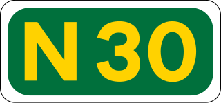
The N30 road is a national primary road in Ireland. It connects the N25 road and M11 motorway, providing a link running east-northeast through County Wexford, between New Ross and Enniscorthy. This provides for a more direct national route between the two towns, as the N25 and N11 both run to Wexford town, eastwards from New Ross and southwards from Enniscorthy respectively.

Campile is a small village situated in County Wexford in the south of Ireland. It is located fourteen kilometres outside the town of New Ross. As of the 2016 census, Campile village had a population of 448 people.

Tuskar Rock is a group of rocks topped by a lighthouse 11 kilometres off the southeast coast of County Wexford, Ireland. It has probably destroyed more ships than any other Irish coastal feature. One hundred and seventy-six wrecks are listed for the Tuskar Rock area at Irish Wrecks Online.

Goresbridge is a small village located in the east of County Kilkenny, in the province of Leinster, Ireland. Goresbridge is named after a 1756 bridge, built by Colonel Ralph Gore, which provides a crossing of the River Barrow between County Kilkenny and County Carlow in the South-East region.

Newbawn is a small village located in the southwest of County Wexford, in Ireland. It is located on the R735 regional road about 3 km south of the N25 national primary road.
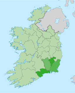
The Ireland South East Region is a NUTS Level III statistical region of Ireland. The region comprises the counties of Waterford, Carlow, Kilkenny and Wexford. Waterford City is the regional capital. The South-East region spans 7,198 km2, 10.2% of the total area of the state and according to the 2016 census had a population of 422,062.
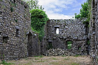
Rathumney Castle is a hall house and National Monument located in County Wexford, Ireland.

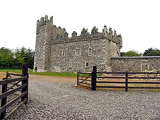
Rathmacknee Castle is a tower house and National Monument located in County Wexford, Ireland.
Coolhull Castle is a fortified house and National Monument located in County Wexford, Ireland.
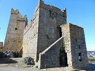
Slade Castle is a tower house and National Monument located in County Wexford, Ireland.
Roscrea Castle is a 13th-century motte castle in the town of Roscrea, Ireland. The Castle consists of a walled courtyard, gate block, and angled towers. Along with 18th century Damer House and gardens, the Castle forms part of Roscrea Heritage Centre.

Johnstown Castle is a Gothic Revival castle located in County Wexford, Ireland.
