Munster is one of the four provinces of Ireland, in the south of Ireland. In early Ireland, the Kingdom of Munster was one of the kingdoms of Gaelic Ireland ruled by a "king of over-kings". Following the Norman invasion of Ireland, the ancient kingdoms were shired into counties for administrative and judicial purposes. In later centuries, local government legislation has seen further sub-division of the historic counties.

County Tipperary is a county in Ireland. It is in the province of Munster and the Southern Region. The county is named after the town of Tipperary, and was established in the early 13th century, shortly after the Norman invasion of Ireland. It is Ireland's largest inland county and shares a border with eight counties, more than any other. The population of the county was 159,553 at the 2016 census. The largest towns are Clonmel, Nenagh and Thurles.

Cahir is a town in County Tipperary in Ireland. It is also a civil parish in the barony of Iffa and Offa West.

Clonmel is the county town and largest settlement of County Tipperary, Ireland. The town is noted in Irish history for its resistance to the Cromwellian army which sacked the towns of Drogheda and Wexford. With the exception of the townland of Suir Island, most of the borough is situated in the civil parish of "St Mary's" which is part of the ancient barony of Iffa and Offa East.

South Tipperary was a county in Ireland. It was part of the South-East Region and in the province of Munster. It was named after the town of Tipperary and consisted of 52% of the land area of the traditional county of Tipperary. South Tipperary County Council was the local authority for the county. The population of the county was 88,433 according to the 2011 census. It was abolished on 1 June 2014, merged with North Tipperary to form County Tipperary under a new Tipperary County Council.
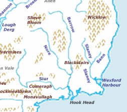
The Three Sisters are three rivers in Ireland: the River Barrow, the River Nore and the River Suir. The Suir and Nore rise in the same mountainous area in County Tipperary, near the Devil's Bit, while the Barrow rises in the Slieve Bloom Mountains in County Laois. The Nore flows into the Barrow about 17 km before the Suir and Barrow join to form an estuary called Waterford Harbour east of the city of Waterford. The rivers fan out to drain a large portion of the southern part of the island, including Counties Tipperary, Carlow, Kilkenny, Wexford and Waterford, among others.
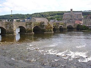
Carrick-on-Suir is a town in County Tipperary, Ireland. It lies on both banks of the River Suir. The part on the north bank of the Suir lies in the civil parish of "Carrick", in the historical barony of Iffa and Offa East. The part on the south bank lies in the civil parish of Kilmolerin in the barony of Upperthird, County Waterford.

Carrick-on-Suir railway station serves the town of Carrick-on-Suir, County Tipperary in Ireland.
Golden is a village in County Tipperary in Ireland. The village is situated on the River Suir. It is located between the towns of Cashel and Tipperary on the N74 road. In older times the village was known as Goldenbridge. It is also a parish in the Roman Catholic Archdiocese of Cashel and Emly, and is in the historical barony of Clanwilliam.

Kilsheelan is a village and civil parish within the in the barony of Iffa and Offa East in County Tipperary, Ireland. It is also one half of the Roman Catholic parish of Kilsheelan & Kilcash in the Roman Catholic Diocese of Waterford and Lismore.
Inislounaght Abbey, also referred to as Innislounaght, Inislounacht and De Surio, was a 12th-century Cistercian settlement on the river Suir, near Clonmel in County Tipperary, Ireland. It was originally dedicated to the Blessed Virgin.

Grallagh Castle is a tower house and National Monument located in County Tipperary, Ireland.
Mothel Abbey is a former Augustinian monastery and National Monument located in County Waterford, Ireland.
Slievenaglasha wedge tomb is a wedge-shaped gallery grave and National Monument located in County Clare, Ireland.

The Main Guard is a National Monument and former courthouse located in Clonmel, Ireland.

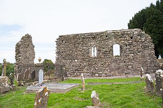
The Priory of St. Mary in Cahir, known as Cahir Abbey, was a medieval priory of Augustinian Canons regular and is a National Monument located in Cahir, Ireland.

The R664 road is a regional road in County Tipperary, Ireland.

Glenahiry is a barony in County Waterford, Ireland.

Upperthird or Upper Third is a barony in County Waterford, Ireland.

The Tipperary Museum of Hidden History is a local history museum in Clonmel, County Tipperary, Ireland. It is designated as museum by the National Museum of Ireland and has full accreditation in the Museum Standards Programme for Ireland (MSPI).
