
A town is a human settlement. Towns are generally larger than villages but smaller than cities, though the criteria to distinguish them vary considerably between different parts of the world.

A village is a clustered human settlement or community, larger than a hamlet but smaller than a town, with a population ranging from a few hundred to a few thousand. Though villages are often located in rural areas, the term urban village is also applied to certain urban neighborhoods. Villages are normally permanent, with fixed dwellings; however, transient villages can occur. Further, the dwellings of a village are fairly close to one another, not scattered broadly over the landscape, as a dispersed settlement.
Indonesia was the first country to be seriously affected by the earthquake and tsunami created by the 2004 Indian Ocean earthquake on 26 December 2004, swamping the northern and western coastal areas of Sumatra, and the smaller outlying islands off Sumatra. Nearly all the casualties and damage took place within the province of Aceh.The time of arrival of the tsunami was between 15 and 30 minutes after the deadly earthquake.
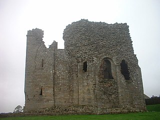
Bowes is a village in County Durham, England. Located in the Pennine hills, it is situated close to Barnard Castle. It is built around the medieval Bowes Castle.

Shikaoi is a town located in Tokachi Subprefecture, Hokkaido, Japan. The name "Shikaoi" means "Following (hunting) deer".

Bettiah is a city and administrative headquarters of West Champaran district - (Tirhut), near Indo-Nepal border, 225 kilometres north-west of Patna, in Bihar state of India.

Denby Dale is a village and civil parish in the metropolitan borough of Kirklees in West Yorkshire, England, to the south east of Huddersfield. The civil parish covers the villages of Denby Dale, Lower Denby, Upper Denby, Upper Cumberworth, Lower Cumberworth, Skelmanthorpe, Emley, Emley Moor. The parish had a population of 14,982 according to the 2001 census, increasing to 16,365 at the 2011 Census. The parish council gives the electorate of the village itself as 2,143. The River Dearne runs through the village; in the floods of 2007 it burst its banks on two separate occasions and caused damage to Springfield Mill.

Kongoussi is a city located in Bam Province in central Burkina Faso, one of the world's poorest countries. It has a population of 18,400 and it is the Provincial capital. Mooré, the language of the Mossi people, is spoken along with French, common among those who have attended school or spent time further afield.

Saighton(listen) is a village and former civil parish, now in the parish of Aldford and Saighton, in the unitary authority of Cheshire West and Chester and the ceremonial county of Cheshire, England, a few miles south of Chester. The 2011 Census recorded a population for the parish of 202. The civil parish was abolished in 2015 to form Aldford and Saighton. Much of the surrounding land is owned by the Duke of Westminster.

Bheemunipatnam popularly known by its abbreviated form Bheemili, is a neighbourhood in the city of Visakhapatnam, India. The town was named after Bhima a character in the Hindu epic Mahabharata. Bheemunipatnam municipality was merged into Greater Visakhapatnam Municipal Corporation
In the United States, the meaning of "village" varies by geographic area and legal jurisdiction. In many areas, "village" is a term, sometimes informal, for a type of administrative division at the local government level. Since the Tenth Amendment to the United States Constitution prohibits the federal government from legislating on local government, the states are free to have political subdivisions called "villages" or not to and to define the word in many ways. Typically, a village is a type of municipality, although it can also be a special district or an unincorporated area. It may or may not be recognized for governmental purposes.
Puttenahalli is a suburban area in Bangalore, Karnataka State in India.

Aguie is a town and capital of the Aguie Department in southern Niger, 69 kilometres east of the nation's second largest city, Maradi.
Fuping is a county of west-central Hebei province, China, bordering Wutai County, Shanxi to the west. It is the westernmost county-level division of the prefecture-level city of Baoding, and is 93 km (58 mi) north-northwest of Shijiazhuang, the provincial capital. As of 2006, it had a population of 210,000 residing in an area of 2,497 km2 (964 sq mi). During December 29–30, 2012 there was a nationally televised visit by Xi Jinping to the villages of Luotuowan and Gujiatai in Longquanguan township which illustrated rural poverty in China. The residents, corn farmers, have an average per capita annual income of $160. Average income for the county as a whole is 2,400 yuan ($390). Following the telecast there was a generous outpouring of aid by the Chinese public to the village. The government has pledged $40 million to Luotuowan and other villages in Fuping County.

Anse-à-Veau is a commune in the Anse-à-Veau Arrondissement, in the Nippes department of Haiti. The postal code is HT 7510.

Vekkalam is a Revenue village in Kannur district in the Indian state of Kerala.
Vazhoor is a town in Kottayam district in the state of Kerala, India.It is a village, panchayat and block with headquarters at Kodungoor on NH183. Basically an agrarian community inhabits this part, whose income depends on rubber cultivation

Harohalli is a village in the southern state of Karnataka, India. It is located in the harohalli taluk of ramanagar district in Karnataka.

Dayr Tarif was a Palestinian Arab village in the Ramle Subdistrict of Mandatory Palestine. It was ethnically cleansed during the 1948 Arab-Israeli War on July 10, 1948.

Kafriya is a village in northern Syria, administratively part of the Idlib Governorate, located northwest of Idlib. Nearby localities include Maarrat Misrin to the north, Zardana to the northeast, Taftanaz to the east and al-Fu'ah and Binnish to the immediate south. According to the Syria Central Bureau of Statistics, Kafriya had a population of 4,404 in the 2004 census. Like nearby al-Fu'ah, Kafriya's inhabitants were predominantly Shia Muslims, while the surrounding areas are predominantly Sunni Muslim.


