Related Research Articles
Wilson County is a county located in the U.S. state of Texas. As of the 2020 census, its population was 49,753. Its county seat is Floresville. The county is named after James Charles Wilson. Wilson County is part of the San Antonio–New Braunfels, Texas, metropolitan statistical area.

Williamson County is a county in the U.S. state of Texas. As of the 2020 census, its population was 609,017. Its county seat is Georgetown. The county is named for Robert McAlpin Williamson, a community leader and a veteran of the Battle of San Jacinto.

Matagorda County is a county located in the U.S. state of Texas. As of the 2020 census, the population was 36,255. Its county seat is Bay City, not to be confused with the larger Baytown in Harris and Chambers Counties. Matagorda County is named for the canebrakes that once grew along the coast.

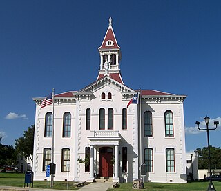
Johnson City is a city and the county seat of Blanco County, Texas, United States. The population was 1,627 at the 2020 census. Founded in 1879 by James P. Johnson, it was named for early settler Sam E. Johnson, Sr. Johnson City is part of the Texas-German belt region.

The Edwards Plateau is a geographic region forming the crossroads of Central, South and West Texas, United States. It is named in honor of Haden Edwards. It is bounded by the Balcones Fault to the south and east; the Llano Uplift and the Llano Estacado to the north; and the Pecos River and Chihuahuan Desert to the west. San Angelo, Austin, San Antonio and Del Rio roughly outline the area. The plateau, especially its southeast portion, is also known as the Texas Hill Country.

Point Reyes National Seashore is a 71,028-acre (287.44 km2) park preserve located on the Point Reyes Peninsula in Marin County, California. As a national seashore, it is maintained by the US National Park Service as an important nature preserve. Some existing agricultural uses are allowed to continue within the park. Clem Miller, a US Congressman from Marin County, wrote and introduced the bill for the establishment of Point Reyes National Seashore in 1962 to protect the peninsula from development which was proposed at the time for the slopes above Drake's Bay.

Juniperus ashei is a drought-tolerant evergreen tree, native from northeastern Mexico and the south-central United States to southern Missouri. The largest areas are in central Texas, where extensive stands occur. Ashe juniper grows up to 10 metres tall, and over time can reach 15 m (49 ft), and provides erosion control and year-round shade for wildlife and livestock.

Tallgrass Prairie National Preserve is a United States National Preserve located in the Flint Hills region of Kansas, north of Strong City. The preserve protects a nationally significant example of the once vast tallgrass prairie ecosystem. Of the 400,000 square miles (1,000,000 km2) of tallgrass prairie that once covered the North American continent, less than 5% remains, primarily in the Flint Hills. Since 2009, the preserve has been home to the Tallgrass Prairie bison herd.

The tallgrass prairie is an ecosystem native to central North America. Historically, natural and anthropogenic fire, as well as grazing by large mammals provided periodic disturbances to these ecosystems, limiting the encroachment of trees, recycling soil nutrients, and facilitating seed dispersal and germination. Prior to widespread use of the steel plow, which enabled large scale conversion to agricultural land use, tallgrass prairies extended throughout the American Midwest and smaller portions of southern central Canada, from the transitional ecotones out of eastern North American forests, west to a climatic threshold based on precipitation and soils, to the southern reaches of the Flint Hills in Oklahoma, to a transition into forest in Manitoba.

The Sandhills, often written Sand Hills, is a region of mixed-grass prairie on grass-stabilized sand dunes in north-central Nebraska, covering just over one quarter of the state. The dunes were designated a National Natural Landmark in 1984.

The Flint Hills, historically known as Bluestem Pastures or Blue Stem Hills, are a region of hills and prairies that lie mostly in eastern Kansas. It is named for the abundant residual flint eroded from the bedrock that lies near or at the surface. It consists of a band of hills extending from Marshall and Washington Counties in the north to Cowley County, Kansas and Kay and Osage Counties in Oklahoma in the south, to Geary and Shawnee Counties west to east. Oklahomans generally refer to the same geologic formation as the Osage Hills or "the Osage."
The Texas Blackland Prairies are a temperate grassland ecoregion located in Texas that runs roughly 300 miles (480 km) from the Red River in North Texas to San Antonio in the south. The prairie was named after its rich, dark soil. Less than 1% of the original Blackland prairie vegetation remains, scattered across Texas in parcels.

The Joseph H. Williams Tallgrass Prairie Preserve, in Osage County, Oklahoma near Foraker, Oklahoma, is the largest protected tract of tallgrass prairie in the world. Managed by The Nature Conservancy, the preserve contains 39,650 acres (160 km2) owned by the Conservancy and another 6,000 acres (24 km2) leased in what was the original tallgrass region of the Great Plains that stretched from Texas to Manitoba.
The Texas Slave Ranch is the name popularly given to a ranch near Mountain Home, Texas where workers who had been abducted were forced to work without pay making cedar keychains that sold throughout the Texas Hill Country. The ranch was raided in 1984 and the operation shut down.

The shortgrass prairie is an ecosystem located in the Great Plains of North America. The two most dominant grasses in the shortgrass prairie are blue grama and buffalograss, the two less dominant grasses in the prairie are greasegrass and sideoats grama. The prairie was formerly maintained by grazing pressure of American bison, which is the keystone species. Due to its semiarid climate, the shortgrass prairie receives on average less precipitation than that of the tall and mixed grass prairies to the east.

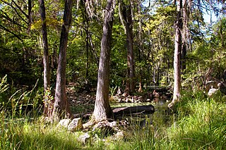
Bull Creek is a tributary of the Colorado River originating in the Texas Hill Country. The creek passes through some of the more scenic areas in the Austin region and forms a greenbelt that is the habitat for many indigenous species of flora and fauna. It runs beneath steep slopes and benches surfaced with shallow clay loams that support ashe juniper, escarpment live oak, mesquite, and grasses.
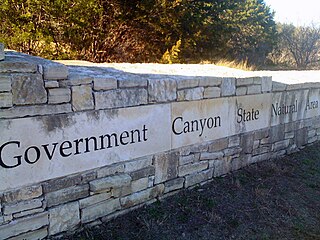
First opened to the public in October, 2005, Government Canyon State Natural Area (GCSNA) preserves 12,244 acres of rugged hills and canyons typical of the Texas Hill Country. It is designated a Natural Area, rather than a State Park, and therefore the primary focus is maintenance and protection of the property's natural state. Accordingly, access and recreational activities may be restricted if the Texas Parks & Wildlife Department (TPWD) deems such action necessary to protect the environment.

Cedar Hill is a city in Dallas and Ellis counties in the U.S. state of Texas. It is located approximately 16 miles (26 km) southwest of downtown Dallas and is situated along the eastern shore of Joe Pool Lake and Cedar Hill State Park. Per the 2020 United States census, the population was 49,148. Cedar Hill is a suburb of the city of Dallas and is part of the Best Southwest area, which includes the nearby cities of DeSoto, Duncanville, and Lancaster.

American Prairie is a prairie-based nature reserve in Central Montana, United States, on a mixed grass prairie ecosystem with migration corridors and native wildlife. This wildlife conservation area is being developed as a private project of the American Prairie Foundation (APF). This independent non-profit organization aims to include over 3 million acres (12,000 km2) through a combination of both private and public lands.
Honey Creek State Natural Area is a nature preserve of almost 2300 acres in western Comal County, Texas, United States. The Texas Parks and Wildlife Department acquired part of the natural area from the Nature Conservancy in 1985 and the rest from a private individual in 1988. Honey Creek opened in 1985 with access by guided tour only. Since Honey Creek is designated a "Natural Area" rather than a "State Park", the Texas Parks and Wildlife Department's first priority is the maintenance and preservation of the property's natural state.
References
- 1 2 Sansom, Andrew (May 19, 2019). "One Man's Half-Century Project to Heal a Hill Country Landscape Created a Legacy Reaching Far Beyond His Fenceline". Texas Highways. Archived from the original on 2021-05-16. Retrieved 2022-06-14.
- ↑ "Our Story". Selah, Bamberger Ranch Preserve. Archived from the original on 2022-04-15. Retrieved 2022-06-15.
- ↑ "Texas Rancher An Unlikely Environmentalist". NPR.org. Archived from the original on 2022-06-15. Retrieved 2022-06-15.
- ↑ "Bamberger Ranch Preserve - Bat-Watching Sites of Texas". tpwd.texas.gov. Archived from the original on 2021-09-20. Retrieved 2022-06-15.