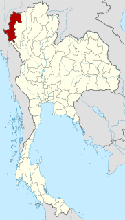
Mae Hong Son Province, also spelled Maehongson, Mae Hong Sorn or Maehongsorn, is one of the northern provinces (changwat) of Thailand, on the country's western border. Neighboring provinces are Shan State of Myanmar, Chiang Mai and Tak. To the west, the province borders Kayin State and Kayah State of Myanmar.
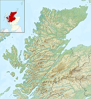
Glen Coe is a glen of volcanic origins, in the Highlands of Scotland. It lies in the north of the county of Argyll, close to the border with the historic province of Lochaber, within the modern council area of Highland. The scenic beauty of the glen has led to its inclusion in the Ben Nevis and Glen Coe National Scenic Area, one of 40 such areas in Scotland. A review of the national scenic areas by Scottish Natural Heritage in 2010 made reference to the "soaring, dramatic splendour of Glen Coe", and "the suddenness of the transition between high mountain pass and the lightly wooded strath" in the lower glen. It also described the journey through the glen on the main A82 road as "one of the classic Highland journeys". The main settlement is the village of Glencoe located at the foot of the glen. The glen is regarded as the home of Scottish mountaineering and is popular with hillwalkers and climbers.

Sai Yok is a district (amphoe) in Kanchanaburi Province in western Thailand.
Saek is a Tai language spoken in at least ten villages in Khammouane Province, Laos, and at least four villages in Nakhon Phanom Province in northeastern Thailand, just across the Mekong River. It is spoken by the Saek people.
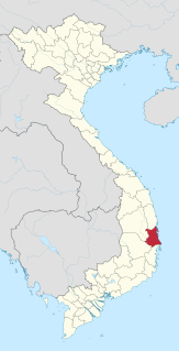
Phú Yên is a coastal province in the South Central Coast of Vietnam. It is the easternmost province of Vietnam's mainland.

The Nam Song River is a small river in Laos that flows through the town of Vang Vieng. It is a popular tourist destination as many people enjoy seeing the Laotian countryside while going down the river in the inner tube of a tractor tyre or in a kayak. The river is surrounded by striking karst rock formations. Upstream from Vang Vieng, numerous bars have been built on the river's banks to attract the tourists floating by.

Theinni or Hsenwi is a town in northern Shan State of Burma, situated near the north bank of the Nam Tu River and now the centre of Hsenwi Township in Lashio District. It is 28 miles north of Lashio. It is 2,100 feet above sea level.

Nam Yuen is the southernmost district (amphoe) of Ubon Ratchathani Province, northeastern Thailand.

The Wang Thong River is a river in Thailand. Its source lies in the Phetchabun Mountains in the Khao Kho District, Thailand. It flows through Thung Salaeng Luang National Park and forms Namtok Sri Dit and Namtok Kaeng Sopha in the Wang Thong District of Phitsanulok Province, and finally flows through into the Bang Krathum District, passing through Ban Sam Ruen and on to the border of Phitsanulok and Phichit, where it drains into the Nan River at 16°31′06″N100°19′36″E. The land drained by the Wang Thong River is part of the Nan Basin and the Chao Phraya Watershed.
An Phú is a district of An Giang Province in the Mekong Delta region of Vietnam on the border with Cambodia. An Phú juts out at the western edge of Vietnam into Cambodia. As of 2003 the district had a population of 178,613. The district covers an area of 226 km². The district capital lies at An Phú town.

Pakxan, Paksan or Muang Pakxan is a town in Bolikhamsai Province, in western Laos. It is the capital of Paksan District. The Nam Xan River joins the Mekong River at Paksan on the border with Thailand, opposite Bung Kan. Paksan is well connected to the south of Laos by Route 13.
Laha is a Kra language spoken by approximately 1,400 people out of a total population of 5,686 Laha. It is spoken in Lào Cai and Sơn La provinces, Vietnam. Laha dialects had been documented in 1986 by Russian linguists and in 1996 by American linguist Jerold A. Edmondson. Many Laha can also converse in the Khmu language, and Laha-speaking areas also have significant Black Thai, Kháng, Ksongmul, and Hmong populations.
Neyinzaya River is a river in Chin State and Sagaing Region of Burma (Myanmar). It is a tributary of the Myittha River, enterring it from the left (west) just south of Kalemyo.

Langkho, Laangkher, or Linkhay is a town and seat of Langkho Township and Langkho District, in the Shan State of eastern Burma. It is located east of Wān Long. It is served by Langhko Airport and is accessed along the National Road 45. A bridge in the vicinity crossing the Nam Teng River the town lies on is called Nam Kok Bridge.

The Luang Prabang Range, named after Luang Prabang, is a mountain range straddling northwestern Laos and Northern Thailand. Most of the range is located in Sainyabuli Province (Laos), as well as Nan and Uttaradit Provinces (Thailand), with small parts in Phitsanulok and Loei Provinces. Several rivers such as the Nan, Pua and Wa river, have their source in this range. Phu Fa waterfall, the biggest and the tallest waterfall in Nan Province, is also located in these mountains. This range is part of the Luang Prabang montane rain forests ecoregion.

Houaphanh province is a province of eastern Laos. As of 2015 it had a population of 289,393 people. Its capital lies at Sam Neua.
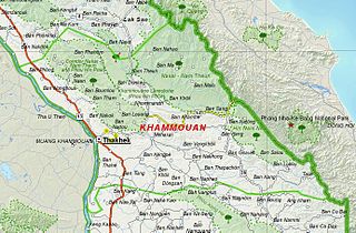
Khammouane or Khammouan is a province of Laos, located in the center of the country. Its capital lies at Thakhek.

Luang Namtha is a province of Laos located in the north of the country. From 1966 to 1976 it formed, together with Bokeo, the province of Houakhong. Luang Namtha Province covers an area of 9,325 square kilometres (3,600 sq mi). Its provincial capital is Luang Namtha. The province borders with Yunnan, China to the north, Oudomxai Province to the east and southeast, Bokeo Province to the southwest, and Shan State, Burma to the northwest.

Xayabuli is a province of Laos, located in the northwest of the country. Xayabuli Province covers an area of 16,389 square kilometres (6,328 sq mi). The province borders Bokeo Province and Oudomxai Province to the north, Luang Prabang Province and Vientiane Province to the east, and the Thai provinces Loei, Phitsanulok, Uttaradit, Nan and Phayao.


