
Chittoor is a city and district headquarters in Chittoor district of the Indian state of Andhra Pradesh. It is also the mandal and divisional headquarters of Chittoor mandal and Chittoor revenue division respectively. The city has a population of 189,332.

Kanipakam is a small mini town in Irala mandal, located in Chittoor district of the Indian state of Andhra Pradesh. Kanipakam is situated at a distance of 11 km from Chittoor city on chittoor-Irala road.

Chittoor district is one of the eight districts in the Rayalaseema region of the Indian state of Andhra Pradesh. It had a population of 18,72,951 at the 2011 census of India. It is a major market centre for mangoes, grains, sugarcane, and peanuts. The district headquarters is at Chittoor City. The major cities/towns in the district are Chittoor, Punganur, Nagari, Palamaner, and Kuppam.
Narayanavanam is a census town in Tirupati district of the Indian state of Andhra Pradesh. It is the headquarters of Narayanavanam mandal in Sri Kalahasti revenue division. The town is known for Kalyana Venkateswara Temple dedicated to Lord Venkateswara and constructed in 1541 AD. This is the place where Lord Sri Venkateswara and Padmavathi Ammavaru marriage was happened.

Nagari is a town in Chittoor district of the Indian state of Andhra Pradesh. It is the mandal headquarters of Nagari mandal in Nagari revenue division.

Pakala is a town in Tirupati district of the Indian state of Andhra Pradesh. It is the mandal headquarters of Pakala mandal. It comes under Tirupati revenue division.
Palamaner or Palamaneru is a town in Chittoor district of the Indian state of Andhra Pradesh. It is the mandal headquarters of Palamaner mandal and Palamaner Revenue Division
Bangarupalyam mandal is one of the 66 mandals in the Chittoor district of the Indian state of Andhra Pradesh. Its headquarters are located at Bangarupalyam. The mandal borders Tamil Nadu and is bounded by Palamaner, Gangavaram, Thavanampalle and Yadamari mandals of Chittoor district.
Tirupati Rural mandal is one of the 34 mandals in Tirupati district of Andhra Pradesh in India. It is under the administration of Tirupati revenue division and the headquarters are located at Tirupati.
Baireddipalle is a Mandal in Palamaner Revenue Division and Chittoor district of the Indian state of Andhra Pradesh. It is the mandal headquarters of Baireddipalle mandal.
Buchinaidu Kandriga mandal or B. N. Kandriga mandal is one of the 33 mandals in Tirupati district of the Indian state of Andhra Pradesh. The mandal headquarters are located at Kanamanambedu. The mandal is bounded by Varadaiahpalem, K.V.B. Puram, Thottambedu mandals.

Puthalapattu is a Mandalam in Chittoor district of the Indian state of Andhra Pradesh. It is the mandal headquarters of Puthalapattu mandal. Puthalapattuis suburban of Chittoor city.
Tirupati Urban mandal is one of the 34 mandals in Tirupati district of the Indian state of Andhra Pradesh. It has its headquarters at Tirupati city&Tirupati district. The mandal is bounded by Chandragiri, Tirupati (rural) mandals. A part of it also borders Annamayya district.
Chittoor mandal is one of the 66 mandals in Chittoor district of the state of Andhra Pradesh in India. Its headquarters are located at Chittoor. The mandal is bounded by Yadamari, Gudipala, Thavanampalle, Puthalapattu, Penumuru, Gangadhara Nellore mandals.
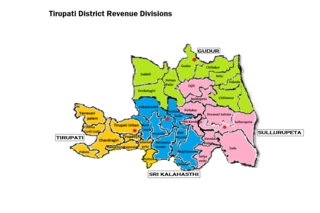
Tirupati revenue division is an administrative division in the Tirupati district of the Indian state of Andhra Pradesh. It is one of the 4 revenue divisions in the district with 9 mandals under its administration. Tirupati serves as the headquarters of the division. The division has 1 municipalities and 1 municipal corporation.
Chandragiri mandal is one of the 34 mandals in Tirupati district of the Indian state of Andhra Pradesh. It is under the administration of Tirupati revenue division and the headquarters are located at Chandragiri.
Srikalahasti mandal is one of the 34 mandals in Tirupati district of the Indian state of Andhra Pradesh. It is under the administration of Srikalahasti revenue division and the headquarters are located at Srikalahasti. The mandal is bounded by Renigunta, Yerpedu, Narayanavanam and Thottambedu.
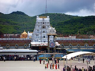
Tirupati district is one of the eight districts of Rayalaseema region in the Indian state of Andhra Pradesh.The district headquarters is located at Tirupati city. This district is known for its numerous historic temples, including the Hindu shrine of Tirumala Venkateswara Temple and Sri Kalahasteeswara temple. The district is also home to Satish Dhawan Space Centre, a rocket launch centre located in Sriharikota.
Narayanavanam mandal is one of the 34 mandals in Tirupati district in the Indian state of Andhra Pradesh. It is administered as a part of Srikalahasti revenue division.
Chinnagottigallu mandal is one of the 34 mandals in Tirupati district in the Indian state of Andhra Pradesh. It is a part of Tirupati revenue division with its headquarters at Chinnagottigallu.


