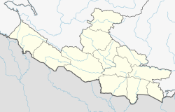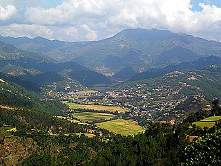
Sandhikharka Municipality is the headquarter of Arghakhanchi District which lies in Lumbini Province of Nepal. The former village development committee (VDC) was converted into a municipality on 18 May 2014 by merging the existing Sandhikharka, Wangla, Narapani, Khanchikot, Kimadada, Argha and Dibharna VDCs evdo. It is located, in a valley surrounded by hills, in the western part of the capital, Kathmandu.

Janalibandali is a market center in Mangalsen Municipality in Achham District in the Seti Zone of western Nepal. The municipality was established merging with existing Janalibandali, Kuntibandali, Oligau, Jupu and Mangalsen village development committees (VDCs) on 18 May 2014. At the time of the 2001 Nepal census, the population was 2913, of which 22% was literate.
Kuntibandali is a market center in Mangalsen Municipality in the Seti Zone of western Nepal. The municipality was established merging with existing Janalibandali, Kuntibandali, Oligau, Jupu and Mangalsen village development committees (VDCs) on 18 May 2014. At the time of the 1991 Nepal census, the village had a population of 2216 living in 409 houses. At the time of the 2001 Nepal census, the population was 2644, of which 32% was literate.
Oligaun is a market center in Mangalsen Municipality in the Seti Zone of western Nepal. The municipality was established merging with existing Janalibandali, Kuntibandali, Oligaun, Jupu and Mangalsen village development committees (VDCs) on 18 May 2014. At the time of the 1991 Nepal census, the village had a population of 3077 living in 657 houses. At the time of the 2001 Nepal census, the population was 3429, of which 41% was literate.

Argha is a Market Center in Sandhikharka Municipality of Arghakhanchi District in Lumbini Province of southern Nepal. Its fort (kot) was the centre of a former Chaubisi kingdom, Argha rajya, which was annexed to Nepal in 1786. The former village development committee (VDC) was converted into a municipality on 18 May 2014 by merging the existing Sandhikharka, wangla, Narapani, Khanchikot, Keemadada, Argha and Dibharna VDCs. At the time of the 1991 Nepal census, the town had a population of 8,248 living in 1,712 houses. At the time of the 2001 Nepal census, the population was 5,947, of which 60% was literate.
Dibharna is a market center in Sandhikharka Municipality of Arghakhanchi District in the Lumbini Zone of Western Nepal. The former village development committee (VDC) was converted into a municipality on 18 May 2014 by merging the existing Sandhikharka, Bangla, Narapani, Khanchikot, Keemadada, Argha and Dibharna VDCs. At the time of the 1991 Nepal census, the town had a population of 4,490 living in 841 houses. At the time of the 2001 Nepal census, the population was 6,990, of which 56% was literate.
Kimadanda is a market center in Sandhikharka Municipality of Arghakhanchi District in the Lumbini Zone of Western Nepal. The former village development committee (VDC) was converted into municipality on 18 May 2014 by merging the existing Sandhikharka, Bangla, Narapani, Khanchikot, Kimadada, Argha and Dibharna VDCs. At the time of the 1991 Nepal census, the town had a population of 5,430 living in 1,085 houses. At the time of the 2001 Nepal census, the population was 3,514, of which 53% was literate.
Khanchikot is a market center in Sandhikharka Municipality of Arghakhanchi District. The district lies in the Lumbini Zone of Western Nepal. The former village development committee (VDC) was converted into municipality on 18 May 2014 by merging the existing Sandhikharka, Bangla, Narapani, Khanchikot, Keemadada, Argha and Dibharna VDCs. During 1991 Nepal census it was estimated to have a total population of 4,628 individuals and had 930 houses.
Narapani is a market center in Sandhikharka Municipality of Arghakhanchi District in the Lumbini Zone of southern Nepal. The former village development committee (VDC) was converted into municipality on 18 May 2014 by merging the existing Sandhikharka, Bangla, Narapani, Khanchikot, Keemadada, Argha and Dibharna VDCs. At the time of the 1991 Nepal census it had a population of 4,664 and had 873 houses in the town.
Bhimapur is a town and market place in Rajapur Municipality in Bardiya District in Lumbini Province of south-western Nepal. The former village development committee (VDC) was merged with Daulatpur, Naya Gaun, Badalpur, Bhimapur and Rajapur VDCs to form the new municipality on 18 May 2014. At the time of the 1991 Nepal census it had a population of 8,057 and had 1,012 houses in the town.
Daulatpur is a town and market place in Rajapur Municipality in Bardiya District in Lumbini Province of south-western Nepal. The former village development committee (VDC) was merged with Daulatpur, Naya Gaun, Badalpur, Bhimapur and Rajapur VDCs to form the new municipality on 18 May 2014. At the time of the 1991 Nepal census it had a population of 5,888 and had 681 houses in the town.
Naya Gaun is a town and market place in Rajapur Municipality in Bardiya District in Lumbini Province of south-western Nepal. The former village development committee (VDC) was merged with Daulatpur, Naya Gaun, Badalpur, Bhimapur and Rajapur VDCs to form the new municipality on 18 May 2014. At the time of the 1991 Nepal census it had a population of 4,741 and had 544 houses in the town.
Dhanushadham is a municipality in Dhanusha District in Province No. 2 of south-eastern Nepal. The municipality was established on 18 May 2014 by merging the existing Govindapur, Umprempur, Yagyabhumi, Dhanushadham village development committees (VDCs). It is a religious place of Hindu worship in Nepal. It is believed that a part of Shiva Dhanusha that was broken by Rama during Sita's swayamvara, is housed. Now there is temple around the remaining of bow and visited by Hindu devotees from all over the world. That's why it is named Dhanushadham.

Chandannath is a municipality in Jumla District in the Karnali province of Nepal. The municipality was established on 18 May 2014 by merging the existing Mahat Gaun, Talium, Kartik Swami (Jumla), and Chandannath village development committees (VDCs). At the time of the 1991 Nepal census it had a population of 5,842 persons living in 1,000 individual households.
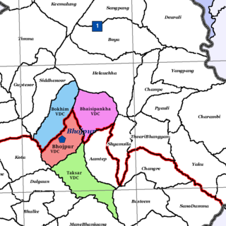
Bokhim is a former VDC and now a neighborhood of Bhojpur Municipality in Bhojpur District in the Province No. 1 of eastern Nepal. At the time of the 1991 Nepal census it had a population of 3438 persons living in 618 individual households.
Ishworpur is a Municipality in Sarlahi District in the Janakpur Zone of south-eastern Nepal. The municipality was established on 18 May 2014 by merging the existing Bela, Bhaktipur, Gaurishankar and Ishwarpur VDCs. At the time of the 1991 Nepal census it had a population of 14,014 people living in 249 individual households.
Pathari Shanishchare (पथरी-शनिश्चरे) is a Municipality in Morang District in the Koshi Zone of south-eastern Nepal. It was formed by merging three existing village development committees i.e. Hasandaha, Pathari and Sanischare in May 2014.
Mukundapur is a town in Gaidakot Municipality in eastern part of Nawalparasi District in the Lumbini Zone of southern Nepal. It became a municipality in May 2014 by merging the existing Mukundapur, Amarapuri, Gaidakot, Nawalparasi, VDCs. At the time of the 1991 Nepal census it had a population of 7631. According to the 2011 Nepal census, the VDC had a population of 13,027 living in 3,023 houses. The VDC is historically important as the "Mukundasen Palace" built by King Madimukundasen of Palpa lies here. The VDC is named after this Palace.

Khairahani is a municipality in Chitwan District in Bagmati Province of southern Nepal. The municipality was established on 8 May 2014 by merging the existing Khairahani, Kumroj and Chainpur VDCs. At the time of the 1991 Nepal census it had a population of 13,629 people living in 2262 households.

Bhojpur is a neighborhood in Bhojpur Municipality which is located in Bhojpur District in Province No. 1 of Nepal. The Bhojpur Village Panchayat was established in 1962 and was renamed as Bhojpur Village development committee in 1990.