Bank of New South Wales Building, Yungaburra | |
---|---|
Bank of New South Wales Building, 1993 | |
Location | 27 Atherton Road, Yungaburra, Tablelands Region, Queensland, Australia |
Coordinates | 17°16′16″S145°34′58″E / 17.2711°S 145.5828°E Coordinates: 17°16′16″S145°34′58″E / 17.2711°S 145.5828°E |
Design period | 1900 - 1914 (early 20th century) |
Built | c. 1914 |
Official name: 27 Atherton Road, Yungaburra, Bank of New South Wales | |
Type | state heritage (built) |
Designated | 21 October 1992 |
Reference no. | 600468 |
Significant period | 1910s (fabric) c. 1914-1967 (historical use) |
Bank of New South Wales is a heritage-listed former bank building at 27 Atherton Road, Yungaburra, Tablelands Region, Queensland, Australia. It was built c. 1914. It was added to the Queensland Heritage Register on 21 October 1992. [1]
A bank is a financial institution that accepts deposits from the public and creates credit. Lending activities can be performed either directly or indirectly through capital markets. Due to their importance in the financial stability of a country, banks are highly regulated in most countries. Most nations have institutionalized a system known as fractional reserve banking under which banks hold liquid assets equal to only a portion of their current liabilities. In addition to other regulations intended to ensure liquidity, banks are generally subject to minimum capital requirements based on an international set of capital standards, known as the Basel Accords.
The Tablelands Region is a local government area in Far North Queensland, Australia inland from the city of Cairns. Established in 2008, it was preceded by four previous local government areas which dated back more than a century. On 1 January 2014, one of those local government areas, the Shire of Mareeba, was re-established independent of the Tablelands Region.
Queensland is the second-largest and third-most populous state in the Commonwealth of Australia. Situated in the north-east of the country, it is bordered by the Northern Territory, South Australia and New South Wales to the west, south-west and south respectively. To the east, Queensland is bordered by the Coral Sea and Pacific Ocean. To its north is the Torres Strait, with Papua New Guinea located less than 200 km across it from the mainland. The state is the world's sixth-largest sub-national entity, with an area of 1,852,642 square kilometres (715,309 sq mi).
The former Bank of New South Wales is a single storeyed timber building erected c. 1914 for local timber merchant Arthur Herbert Belson on the corner of Atherton Road and Cedar Street. For over fifty years, it housed the local branch of the Bank of New South Wales. [1]
The Bank of New South Wales (BNSW), also known commonly as The Wales, was the first bank in Australia, being established in Sydney in 1817 and situated on Broadway. During the 19th and early 20th century, the Bank opened branches first throughout Australia and Oceania. It merged with many other financial institutions, finally merging with the Commercial Bank of Australia in 1982 to form the Westpac Banking Corporation.
Yungaburra, previously known as Allumbah (meaning red cedar) Pocket, was surveyed in 1886 by Surveyor Rankin as part of a government village settlement scheme. In 1910, the Cairns to Millaa Millaa railway reached the town, which was renamed to avoid confusion with another similarly named town. In 1926, the Gillies Highway between Cairns and Gordonvale was opened. Fuelled by the resulting tourist trade to the nearby lakes, the town experienced a second period of development. [1]
The Tablelands line is a railway line in North Queensland, Australia. It was opened in a series of sections between 1887 and 1916. It commences at Cairns and at its maximum extent, reached Ravenshoe at the southern end of the Atherton Tableland. The rail system served by this line was unusual for Queensland in that the majority of lines that connected to it were built by private companies and later purchased by the Queensland Government.
The Gillies Highway is a road that runs from Gordonvale in the Cairns Region through the Gillies Range to Atherton in the Tablelands Region, both in Queensland, Australia. It is also known as the Gillies Range Road and was originally known as the Cairns Range Road.
Cairns is a city in the Cairns Region, Queensland, Australia. It is on the east coast of Far North Queensland. The city is the 5th-most-populous in Queensland and ranks 14th overall in Australia.
In 1914, the building which was sited opposite the new Yungaburra railway station, was leased to the Bank of New South Wales. Previously the Bank had occupied temporary premises in the town. In 1921, the property was purchased by the Bank. Photographs at this time show the building to be single skinned. According to local folklore, the bank was part of a New Year's Eve prank, in which the railway gates were removed, taken across the road, and left on the awning of the bank. This was regarded as a feat of strength on the part of the young people of the town. [1]
In 1965, the Yungaburra branch was converted to an agency attached to the Atherton branch of the Bank. In 1967, the agency was closed and the property sold by the Bank of New South Wales in the following year. It was acquired by the present owners in 1988. [1]
This single-storeyed timber building with a corrugated iron gable roof is located on the corner of Atherton Road and Cedar Street in the centre of Yungaburra. Originally an exposed framed, single skin building, it has been clad in chamferboard. [1]
A gable is the generally triangular portion of a wall between the edges of intersecting roof pitches. The shape of the gable and how it is detailed depends on the structural system used, which reflects climate, material availability, and aesthetic concerns. A gable wall or gable end more commonly refers to the entire wall, including the gable and the wall below it.
The street frontage to Atherton Road to the east has a reconstructed curved corrugated iron awning with a shaped gable above. The building is divided into two tenancies, with the Atherton Road end having a central entry from the awning and the rear tenancy accessed via a timber deck off Cedar Street. [1]
The building has principally sash windows, with some later casements. A lean-to bathroom has been added to the southwest. The building has been recently refurbished, with new timber floors and some new windows. The rear of the site is grassed. [1]
The former Bank of New South Wales Building was listed on the Queensland Heritage Register on 21 October 1992 having satisfied the following criteria. [1]
The place is important in demonstrating the evolution or pattern of Queensland's history.
The building is important in demonstrating the pattern of Queensland's history, in particular the development of Yungaburra and the Atherton Tableland. [1]
The place is important because of its aesthetic significance.
It exhibits a range of aesthetic characteristics valued by the local community, in particular its contribution, through scale, form and materials, to the Yungaburra townscape. [1]
Yungaburra is a town located on the Atherton Tableland in Far North Queensland, Australia, not far from Cairns. In the 2011 census, Yungaburra had a population of 1,116 people.
The Atherton Tableland is a fertile plateau which is part of the Great Dividing Range in Queensland, Australia. The Atherton Tablelands is a diverse region, covering an area of 64,768 square kilometres and home to 45,243 people. The main population centres on the Atherton Tablelands are Mareeba and Atherton. Smaller towns include Malanda, Herberton, Kuranda, Ravenshoe, Millaa Millaa, Chillagoe, Dimbulah, Mt Garnet, Mt Molloy, Tinaroo and Yungaburra.
Curtain Fig Tree is a heritage-listed tree at Curtain Fig Tree Road, Yungaburra, Tablelands Region, Queensland, Australia. It is one of the largest trees in Tropical North Queensland, Australia, and one of the best known attractions on the Atherton Tableland. It was added to the Queensland Heritage Register on 3 December 2009.
The Shire of Eacham was a local government area of Queensland. It was located on the Atherton Tableland, a plateau forming part of the Great Dividing Range west of the city of Cairns. The shire, administered from the town of Malanda, covered an area of 1,126.4 square kilometres (434.9 sq mi), and existed as a local government entity from 1910 until 2008, when it amalgamated with several other councils in the Tableland area to become the Tablelands Region.
Atherton State School Head Teacher's Residence is a heritage-listed school residence at 42 Mable Street, Atherton, Tablelands Region, Queensland, Australia. It was designed and built by the Queensland Department of Public Works in 1913. It is also known as Atherton Provisional School, Enterprise House, and former Principal's Residence. It was added to the Queensland Heritage Register on 21 October 1992.
Jack & Newell General Store is a heritage-listed pair of shops at Grace Street, Herberton, Tablelands Region, Queensland, Australia. They were built c. 1882 and in 1895. It was added to the Queensland Heritage Register on 22 April 1993.
Malanda Falls Swimming Pool is a heritage-listed swimming pool at Malanda Falls Park, Malanda, Tablelands Region, Queensland, Australia. It was built in 1906 onwards. It was added to the Queensland Heritage Register on 5 February 2010.
Lake Eacham Hotel is a heritage-listed hotel at 6-8 Kehoe Place, Yungaburra, Tablelands Region, Queensland, Australia. It was built in 1910 by Side Brothers. It was added to the Queensland Heritage Register on 21 October 1992.
Cairns Plywood Pty Ltd Sawmill Complex is a heritage-listed sawmill at 25 - 33 Eacham Road, Yungaburra, Tablelands Region, Queensland, Australia. It was built from 1910 to 1980s. It is also known as Cairns Plywood Limited, Eacham Sawmills, and Williamson Brothers Sawmill. It was added to the Queensland Heritage Register on 21 October 1992.
St Patrick's Catholic Church is a heritage-listed church at 1 Penda Street, Yungaburra, Tablelands Region, Queensland, Australia. It was built from 1914 to 1930s. It is also known as Our Lady of Ransom. The church is part of the Roman Catholic Diocese of Cairns. It was added to the Queensland Heritage Register on 21 October 1992.
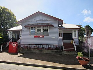
Yungaburra Post Office is a heritage-listed post office at 15-17 Cedar Street, Yungaburra, Tablelands Region, Queensland, Australia. It was built in 1926. It was added to the Queensland Heritage Register on 21 October 1992.
Yungaburra Court House is a heritage-listed courthouse at 6 - 10 Cedar Street, Yungaburra, Tablelands Region, Queensland, Australia. It was built from 1909 to 1921. It is also known as Court of Petty Sessions. It was added to the Queensland Heritage Register on 21 October 1992.
Eden House Restaurant is a heritage-listed detached house at 20 Gillies Highway, Yungaburra, Tablelands Region, Queensland, Australia. It was built c. 1914. It is also known as Nibbles Tea House. It was added to the Queensland Heritage Register on 21 October 1992.
Yungaburra Community Centre is a heritage-listed community hall at 19 Cedar Street, Yungaburra, Tablelands Region, Queensland, Australia. It was built from 1910 to c. 1926. It is also known as Tivoli picture theatre, Williams Estate Hall, and Yungaburra Hall. It was added to the Queensland Heritage Register on 21 October 1992.
Barbers's Shop is a heritage-listed former barber shop at 34 Cedar Street, Yungaburra, Tablelands Region, Queensland, Australia. It was built c. 1925. It was also known as Burra Inn Restaurant and The Workshop. It was added to the Queensland Heritage Register on 21 October 1992.
Allumbah is a heritage-listed detached house at 7 Mulgrave Road, Yungaburra, Tablelands Region, Queensland, Australia. It was built c. 1926. It is also known as Artist's Gallery. It was added to the Queensland Heritage Register on 21 October 1992.
Williams' House is a heritage-listed detached house at 16-20 Cedar Street, Yungaburra, Tablelands Region, Queensland, Australia. It was built from c. 1915 to the 1940s. It was added to the Queensland Heritage Register on 21 October 1992.
Billy Madrid's House is a heritage-listed shop at 32 Cedar Street, Yungaburra, Tablelands Region, Queensland, Australia. It was built c. 1925. It is also known as Special Glass Company Shop, T.A.B. Agency, and Tailor's shop. It was added to the Queensland Heritage Register on 21 October 1992.
7-9 Cedar Street, Yungaburra is a heritage-listed pair of shops at 7-9 Cedar Street, Yungaburra, Tablelands Region, Queensland, Australia. They were built in the 1920s. They were added to the Queensland Heritage Register on 15 March 1996.
Butchers Shop is a heritage-listed butcher shop at 2 Kehoe Place, Yungaburra, Tablelands Region, Queensland, Australia. It was built c. 1922. It was added to the Queensland Heritage Register on 21 October 1992.