Related Research Articles

Corner Brook is a city located on the west coast of the island of Newfoundland in the province of Newfoundland and Labrador, Canada. Corner Brook is the fifth largest settlement in Newfoundland and Labrador.

The Bay of Islands is an extensive inlet located on the west coast of the island of Newfoundland, in Canada. The Way Office was established on July 1, 1883. The first Waymaster was Thomas Carter. The largest island in the bay is Woods Island. It is surrounded in most directions by the Long Range Mountains and it is directly north of the Lewis Hills.

Avalon is a federal electoral district on Newfoundland Island in Newfoundland and Labrador, Canada. It has been represented in the House of Commons of Canada since 2004.

Humber—St. Barbe—Baie Verte was a federal electoral district in Newfoundland and Labrador, Canada, that was represented in the House of Commons of Canada from 1988 to 2015.
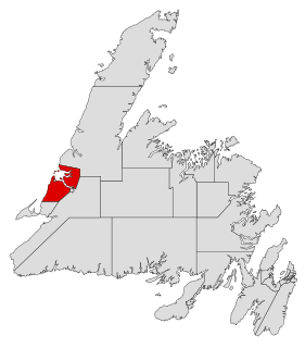
Humber-Bay of Islands is a provincial electoral district for the House of Assembly of Newfoundland and Labrador, Canada. As of 2015, the district has 13,412 eligible voters.

Baie Verte-Green Bay is a provincial electoral district for the House of Assembly of Newfoundland and Labrador, Canada. As of 2011 it has 8,067 eligible voters. The district was redistributed in 2015.

The Straits – White Bay North is a defunct provincial electoral district for the House of Assembly of Newfoundland and Labrador, Canada. The district was known as Strait of Belle Isle prior to the 1996 election. In the 2007 redistribution, it added five per cent of St. Barbe. As of 2011, there are 6,851 eligible voters living within the district.

Grates Cove is a local service district and designated place in the Canadian province of Newfoundland and Labrador. It is the most northerly community on the Avalon Peninsula, located on the tip of the Bay de Verde Peninsula on the island of Newfoundland. Called "the Grates" by John Guy as early as 1612, the origin of the name is unknown.
Piccadilly Slant-Abraham's Cove is a local service district and designated place in the Canadian province of Newfoundland and Labrador. It is located on the island of Newfoundland, along St. George's Bay, on the Port au Port Peninsula. The DPL consists of the fishing villages of Abraham's Cove and Piccadilly.
Curling is a mainly residential neighbourhood of the city of Corner Brook, Newfoundland and Labrador. It is situated just west of the main part of the city. Located in the Humber Arm of the Bay of Islands, Curling was originally a fishing community. It is the oldest section of Corner Brook.
Steady Brook is a Canadian town in the province of Newfoundland and Labrador. Located on the west coast of the island of Newfoundland, the town is situated 8 kilometres east of the city of Corner Brook in the lower Humber Valley. The town is surrounded by the Long Range Mountains and sits astride the Humber River. Steady Brook has become a thriving community in recent years as a result of provincial investments in the Marble Mountain alpine ski resort, along with golf courses and other recreational amenities.
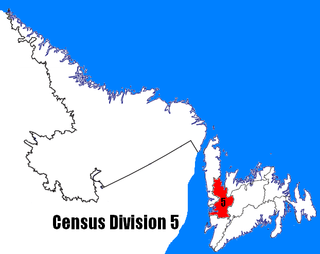
Census Division No. 5 is a Statistics Canada statistical division composed of the areas of the province of Newfoundland and Labrador called Humber Valley, Bay of Islands, and White Bay. It covers a land area of 10,365.63 km², and had a population of 42,014 according to the 2016 census.
Dover is a small incorporated fishing and lumbering village located in a small cove at the head of Freshwater Bay, Bonavista Bay, Newfoundland, Canada. Settled in the early 1890s it was originally known as Shoal Bay, presumably from its many shallow coves and inlets in the area. From the 1950s to the 1970 Shoal Bay was referred to as Wellington , whereas the local residents called it Dover.
The Bonavista Peninsula is a large peninsula on the east coast of the island of Newfoundland in the Canadian province of Newfoundland and Labrador. It consists of 50 incorporated towns/unincorporated communities which have a population of 12,176 as of the 2016 Canadian Census. Bonavista is the largest population centre on the peninsula.

Hampden is a town in the Canadian province of Newfoundland and Labrador. The town has a population of 429. Two islands can be seen from the shore of Hampden, Granby Island and Millers Island. The latter is much closer to the town and is the host of a tuberculosis grave-site.

Humber Arm South is a town in the Canadian province of Newfoundland and Labrador. The town had a population of 1,537 in the Canada 2021 Census. The Town's Post Office is located in the section of the town referred to as Benoit's Cove. Humber Arm South is located in the Bay of Islands, and is in the Humber-Bay of Islands electoral district.

St. Brendan's is a town in the Canadian province of Newfoundland and Labrador, situated in Shoal Cove on Cottel Island in Bonavista Bay. Other settlements on the island include Shalloway Cove, Haywards Cove, and Dock Cove. The town had a population of 125 in the Canada 2021 Census. St. Brendan's is inaccessible by road and is served by a daily ferry service from Burnside.
Long Range Mountains is a federal electoral district in the Canadian province of Newfoundland and Labrador. It covers the entirety the west coast of the island of Newfoundland.

Division No. 1, Subdivision G is an unorganized subdivision on the Avalon Peninsula in Newfoundland and Labrador, Canada. It is in Division 1 and contains the unincorporated communities of Baccalieu Island, Besom Cove, Bradley's Cove, Burnt Point, Caplin Cove, Daniel's Cove, Grates Cove, Gull Island, Job's Cove, Kingston, Long Beach, Lower Island Cove, Low Point, Northern Bay, Ochre Pit Cove, Red Head Cove, Riverhead, Smooth Cove and Western Bay.
References
- ↑ "Humber - Bay of Islands" (PDF). Newfoundland and Labrador Department of Finance. 2017. Retrieved 2021-12-20.
- ↑ "Notice of Intent: Section 7 of the Lands Act" (PDF). Newfoundland and Labrador Fisheries and Land Resources. 2018. Retrieved 2021-12-19.
- 1 2 Census of Newfoundland and Labrador, 1901.
- ↑ "Gazette of January 22nd, 1918" (PDF). Archive. 1918. Retrieved 2021-12-19.
- ↑ Crocker, Diane (2014-07-25). "ACAP trapping green crab to try and eradicate the invasive species from the Bay of Islands". SaltWire. Retrieved 2021-12-19.
48°57′58.59″N58°1′36.46″W / 48.9662750°N 58.0267944°W
| | This Newfoundland and Labrador location article is a stub. You can help Wikipedia by expanding it. |
| | This Labrador location article is a stub. You can help Wikipedia by expanding it. |