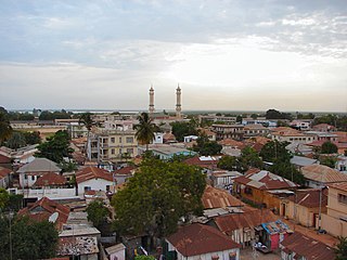
Banjul, officially the City of Banjul and formerly known as Bathurst, is the capital and second largest city of The Gambia. It is the centre of the eponymous administrative division which is home to an estimated 400,000 residents, making it The Gambia's largest and densely populated metropolitan area. Banjul is on St Mary's Island, where the Gambia River enters the Atlantic Ocean. The population of the city proper is 31,301, with the Greater Banjul Area, which includes the City of Banjul and the Kanifing Municipal Council, at a population of 413,397. The island is connected to the mainland to the west and the rest of Greater Banjul Area via bridges. There are also ferries linking Banjul to the mainland at the other side of the river.
Telecommunications in the Gambia includes radio, television, fixed and mobile telephones, and the Internet.

The demographic characteristics of the population of The Gambia are known through national censuses, conducted in ten-year intervals and analyzed by The Gambian Bureau of Statistics (GBOS) since 1963. The latest census was conducted in 2013. The population of The Gambia at the 2013 census was 1.8 million. The population density is 176.1 per square kilometer, and the overall life expectancy in The Gambia is 64.1 years. Since the first census of 1963, the population of The Gambia has increased every ten years by an average of 43.2 percent. Since 1950s, the birth rate has constantly exceeded the death rate; the natural growth rate is positive. The Gambia is in the second stage of demographic transition. In terms of age structure, The Gambia is dominated by 15- to 64-year-old segment (57.6%). The median age of the population is 19.9 years, and the gender ratio of the total population is 0.98 males per female.
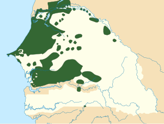
Wolof is a language of Senegal, the Gambia and Mauritania, and the native language of the Wolof people. Like the neighbouring languages Serer and Fula, it belongs to the Senegambian branch of the Niger–Congo language family. Unlike most other languages of the Niger-Congo family, Wolof is not a tonal language.

Basse Santa Su, usually known as Basse, is a town in the Gambia, lying on the south bank of the River Gambia. The easternmost town in the nation, it is known for its important market. As of 2009 it has an estimated population of 18,414.

Etah district is one of the districts of Uttar Pradesh state of India, and Etah town is the district headquarters. Etah district is a part of Aligarh Division. The driving distance from New Delhi to Etah is 207 km.

Sant Kabir Nagar district is one of the 75 districts of Uttar Pradesh state in northern India. Khalilabad city is the district headquarters. Sant Kabir Nagar district is a part of Basti division.

Chhatarpur District is a district of Madhya Pradesh state of central India. The town of Chhatarpur is the district headquarters.

Islam is the majority religion of the Gambia, with around 95% of the population being Muslims. Other religious societies are made up of Catholics, Protestants, and Traditional African religion. Islam in the Gambia is characterized by its coexistence with other religions. The majority of its Muslims are Sunni belonging to Maliki school of jurisprudence, influenced with Sufism. The Ahmadiyya movement is also present. However, some popular religious and tribal practices diverge from mainstream Islam, with a system of marabout societies being very common.
The Aku, Krio, or Creole are a minority ethnic group of Gambia with roots among the Sierra Leone Creole people.
The Catholic Church in the Gambia is part of the worldwide Catholic Church, under the spiritual leadership of the Pope in Rome. Gambia is a predominantly Muslim country. The Diocese of Banjul covers the whole of the country. Relations between the Muslim and Christian communities in Gambia are generally very good. The Catholic Church operates various missions including schools which children of Muslim parents attend. Of the minority Christian population, there are around 30,000 Catholics, which represents around 2% of the population.

The Gambia Football Federation (GFF), formerly known as the Gambia Football Association, is the governing body of football in Gambia. It was founded in 1952, and affiliated to FIFA in 1968 and to CAF in 1966. It organizes the national football league and the national team.

The Gambia is divided into five administrative Regions and one City. The divisions of the Gambia are created by the Independent Electoral Commission in accordance to Article 192 of the National Constitution.

Sandu District is one of the four districts of the Upper River Division of The Republic of Gambia. It contains the town of Diabugu.
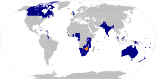
The Commonwealth of Nations is a voluntary association of 53 sovereign states. Nearly all of them are former British colonies or dependencies of those colonies.

The following outline is provided as an overview of and topical guide to the Gambia:

Gunjur is a small coastal town in south-western Gambia. It is located in Kombo South District in the Western Division. As of 2009, it has an estimated population of 17,520.

Christians in the Gambia constitute approximately 8 percent (~136,400) of the country's population
Gambian Sign Language is a national sign language used in Gambia by the deaf community there. The only school for deaf children in the Gambia, St John's School for the Deaf, was set up by a Catholic priest from Ireland. Dutch Sign Language was introduced to the school along with British Sign Language which developed into Gambian Sign Language, incorporating some indigenous gestures used by the general population. Unlike much of West Africa, American Sign Language was not introduced to the Gambia until much later so the deaf community is not familiar with American Sign Language.
