
The Gambia is a very small and narrow African country with the border based on the Gambia River. The country is less than 48 kilometres (30 mi) wide at its greatest width. The country's present boundaries were defined in 1889 after an agreement between the United Kingdom and France. It is often claimed by Gambians that the distance of the borders from the Gambia River corresponds to the area that British naval cannon of the time could reach from the river's channel. However, there is no historical evidence to support the story, and the border was actually delineated using careful surveying methods by the Franco-British boundary commission. The Gambia is almost an enclave of Senegal and is the smallest country on mainland Africa.

The Gambia River is a major river in West Africa, running 1,120 kilometres (700 mi) from the Fouta Djallon plateau in north Guinea westward through Senegal and The Gambia to the Atlantic Ocean at the city of Banjul. It is navigable for about half that length.

Upper River was one of the five Divisions of the Gambia. Its capital was Basse Santa Su. It was subsequently reorganised as the Basse Local Government Area, without any change in the area covered.
Kerewan is a town in the Gambia. Located beside the Miniminiyang Bolong, about 60 km from the capital Banjul. It is the seat of the of the Kerewan Local Government Area, located on the north bank of the lower river Gambia.
The Gambia is subdivided into 43 districts. They are listed below by Local Government Area, each with its population at the 15 April 2013 census.

Fulladu West is one of the ten districts of the Central River Division of the Gambia.
Niamina East is one of the ten districts of the Central River Division of the Gambia. Its population in the 2013 census was 24,571.
Nianija is one of the ten districts of the Central River Division of the Gambia. In the 2013 census, it had a population of 10,175.

Fulladu East was one of the four districts of the Upper River Division of the Gambia. The Upper River Division is now the Basse Local Government Area, and the former Fulladu East District is now divided into a Basse Fulladu East District, a Jimara District and a Tumana District.
Baja Kunda is a town in eastern Gambia. It is located in Wuli East District in the Upper River Division. As of 2008, it has an estimated population of 5,924. Located just south of the north bank highway, Baja Kunda boasts an elementary, secondary, and senior secondary school as well as the main health center in the Wuli East district. A few kilometers to the southwest is the old river port of Fattatenda.
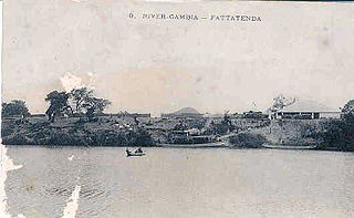
Fattatenda is a small village in eastern Gambia on the Gambia River. It is located in Wuli District in the Upper River Divisiont, a few kilometers southwest of the much larger village of Baja Kunda. As of 2009, it has an estimated population of 49.
Banni is a village in the Gambia. It is located in Wuli District in the Upper River Division. As of 2009, it has an estimated population of 461.
Bantango Koto is a village in the Gambia. It is located in Wuli District in the Upper River Division. As of 2009, it has an estimated population of 327.
Bantunding is a village in the Gambia. It is located in Wuli East District in the Upper River Division. As of 2009, it has an estimated population of 1114. Bantunding is home to several traditional rulers locally known as (Seyfo). The last chief from the village is called Sergeant Madi Wally. Madi Wally’ Father Jumu Wally also served as chief.
Barrow Kunda is a town in the Gambia. Barrow is the name of the Alkalo and Kunda means compound. It is located in Wuli District in the Upper River Division. There is another Barrow Kunda located in Foni Kansala district which is not to be confused with this Barrow Kunda. The Barrow Kunda in Foni Kansala District (Bwiam) has a newly built modern hospital and also a new indoor market which as of mid-2010 is still unopened. The main road S. Bank Road runs through the village. The Alkalo is intending to put the town on the map as a modern town so he is offering land to foreigners who would like to settle in this rural location at a lower cost compared to other more coastal or town based areas. A growing number of foreign nationals have bought and own land in Barrow Kunda. There are also some new developments due to begin construction in 2012, so this village although quiet and rural is set to become modern whilst retaining its calm and peaceful rural location. Those who want rural but modern should consider Barrow Kunda in Foni Kansala District (Bwiam). The Barrow Kunda in Wuli District has as of 2009, an estimated population of 1 730.
Boro Dampha Kunda is a town in the Gambia. It is located in Wuli District in the Upper River Division. As of 2009, it has an estimated population of 353.
Boro Kanda Kassy is a town in the Gambia. It is located in Wuli District in the Upper River Division. As of 2009, it has an estimated population of 1091.
Chamoi Bunda is a town in the Gambia. It is located in Wuli District in the Upper River Division. As of 2009, it has an estimated population of 785.
Wuli was a kingdom located on the north bank of the Gambia River in what is now the eastern portion of The Gambia and the Tambacounda region of Senegal. It was ruled by the Wally family. The capital was located in the village of Bantunding.
