The Gambia is a very small and narrow African country with the border based on the Gambia River. The country is less than 48 kilometres (30 mi) wide at its greatest width. The country's present boundaries were defined in 1889 after an agreement between the United Kingdom and France. It is often claimed by Gambians that the distance of the borders from the Gambia River corresponds to the area that British naval cannon of the time could reach from the river's channel. However, there is no historical evidence to support the story, and the border was actually delineated using careful surveying methods by the Franco-British boundary commission. The Gambia is almost an enclave of Senegal and is the smallest country on mainland Africa.

The Gambia River is a major river in West Africa, running 1,120 kilometres (700 mi) from the Fouta Djallon plateau in north Guinea westward through Senegal and The Gambia to the Atlantic Ocean at the city of Banjul. It is navigable for about half that length.

Basse Santa Su, usually known as Basse, is a town in the Gambia, lying on the south bank of the River Gambia. The easternmost major town in the nation, it known for its important market. Basse is the capital of the Upper River Division, which is coterminous with the Basse Local Government Area. As of 2009, the town has an estimated population of 18,414. According to the 2013 census, the Basse LGA has 243,791 residents.

Hazaribagh district is one of the oldest districts of Jharkhand state, India and the district headquarter located in Hazaribagh town. It is located in the north east part of North Chotanagpur Division. The boundary of this district consists of districts of Gaya (BIHAR) and Koderma in the north, Giridih and Bokaro in the east, Ramgarh in the south and Chatra in the west.

West Coast Region, originally the Western Division, also known as Foni or Fonyi, was one of the five administrative divisions of the Gambia. Its capital was Brikama. It was subsequently reorganised as the Brikama Local Government Area (LGA), without any change in the area covered.
Bintanding Jarju is a former member of the Pan-African Parliament of the African Union from the Gambia. She is the former member of the National Assembly for Foni Brefet.

The Gambia is subdivided into 43 districts. They are listed below by Local Government Area, each with its population at the 15 April 2013 census.

Foni Bondali is one of the nine districts of the Gambia's Western Division, which is located to the south of the Gambia River in the southwest of the country. Foni Bondali is in the southeast of the division, between Foni Kansala and Foni Jarrol.

Foni Brefet is one of the nine districts of the Gambia's Western Division, which is located to the south of the Gambia River in the southwest of the country. Foni Brefet is in the center of the division, between Kombo East and Foni Bintang-Karenai.

Foni Jarrol is one of the nine districts of the Gambia's Western Division, which is located to the south of the Gambia River in the southwest of the country. Foni Jarrol is in the far east of the division, between Foni Bondali and the border with Senegal.

Foni Kansala is one of the nine districts of the Gambia's West Coast Region, which is located to the south of the Gambia River in the southwest of the country. Foni Kansala is in the southeast of the division, between Foni Bintang-Karenai and Foni Bondali.

Kombo Central is one of the nine districts of the Gambia's Western Division, which is located to the south of the Gambia River in the southwest of the country. Kombo Central is in the southwest of the division, between Kombo East and Kombo South. In the 2013 census, it had a population of 142,831.

Kombo East is one of the nine districts of the Gambia's Western Division, which is located to the south of the Gambia River in the southwest of the country. Kombo East is in the central south of the division, between Kombo Central and Foni Brefet.

Kombo North/Saint Mary is one of the nine districts of the Gambia's Brikama Local Government Area, which is located to the south of the Gambia River in the southwest of the country. Kombo North/Saint Mary is in the northwest of the LGA, between Kombo South and Kanifing LGA. It is the only district in the LGA with coasts on both the Atlantic Ocean and the Gambia River, and is the most populated district in the LGA, with 344,756 inhabitants at the 2013 Census.

Kombo South is one of the nine districts of the Gambia's Western Division, which is located to the south of the Gambia River in the southwest of the country. Kombo South is in the southwest of the division, between Kombo Central and Kombo North/Saint Mary. In the 2013 census, it had a population of 108,773.

Niamina West is one of the ten districts of the Central River Division in the Gambia. In the 2013 census, it had a population of 7,293.

Jarra East is one of the six districts of the Lower River Division of the Gambia. In the 2013 census, it had a population of 16,551.

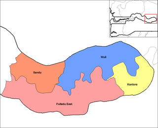
Fulladu East was one of the four districts of the Upper River Division of the Gambia. The Upper River Division is now the Basse Local Government Area, and the former Fulladu East District is now divided into a Basse Fulladu East District, a Jimara District and a Tumana District.
The tourism industry today in the Gambia started when a party of 300 Swedish tourists arrived in 1965. That pioneering trip was organised by a Swede named Bertil Harding together with the tour operators Vingresor. It was seen as an ideal place to escape the harsh winter months of Scandinavia where Europeans would enjoy not only sun, sand and beaches but also experience the excitement of a real African holiday. It also offered a new opening for an affordable holiday to increasing numbers of traveling Europeans.
Barrow Kunda is a town in the Gambia. It is located in Wuli District in the Upper River Division. According to tradition the village was founded in the 16th century by Alai Bah, a marabout from Futa Toro. The king of Wuli at the time, Mansa Jalali Wali convinced him to settle there by promising him autonomy to practice Islam and protection from search and seizure.


