
USS Block Island (CVE-21/AVG-21/ACV-21) was a Bogue-class escort carrier for the United States Navy during World War II. She was the first of two escort carriers named after Block Island Sound off Rhode Island and was the only American carrier sunk in the Atlantic during the war.
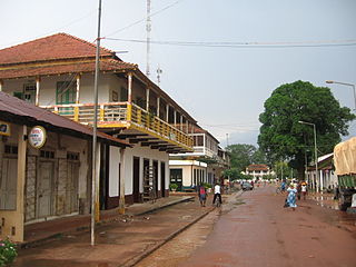
Gabu is the largest city in eastern Guinea-Bissau, the second most populated city in Guinea-Bissau and capital of the Gabu Region.

Basse Santa Su, usually known as Basse, is a town in the Gambia, lying on the south bank of the River Gambia. The easternmost major town in the nation, it known for its important market. Basse is the capital of the Upper River Division, which is coterminous with the Basse Local Government Area. As of 2009, the town has an estimated population of 18,414. According to the 2013 census, the Basse LGA has 243,791 residents.

Inchmurrin is an island in Loch Lomond in Scotland. It is the largest fresh water island in the British Isles.

West Coast Region, originally the Western Division, also known as Foni or Fonyi, was one of the five administrative divisions of the Gambia. Its capital was Brikama. It was subsequently reorganised as the Brikama Local Government Area (LGA), without any change in the area covered.
Bintanding Jarju is a former member of the Pan-African Parliament of the African Union from the Gambia. She is the former member of the National Assembly for Foni Brefet.
The Gambia is subdivided into 43 districts. They are listed below by Local Government Area, each with its population at the 15 April 2013 census.

Foni Bintang-Karenai is one of the nine districts of the Gambia's Western Division, which is located to the south of the Gambia River in the southwest of the country. Foni Bintang-Karenai is in the central south of the division, between Foni Kansala and Foni Brefet.
Foni Bondali is one of the nine districts of the Gambia's Western Division, which is located to the south of the Gambia River in the southwest of the country. Foni Bondali is in the southeast of the division, between Foni Kansala and Foni Jarrol.
Foni Brefet is one of the nine districts of the Gambia's Western Division, which is located to the south of the Gambia River in the southwest of the country. Foni Brefet is in the center of the division, between Kombo East and Foni Bintang-Karenai.
Foni Jarrol is one of the nine districts of the Gambia's Western Division, which is located to the south of the Gambia River in the southwest of the country. Foni Jarrol is in the far east of the division, between Foni Bondali and the border with Senegal.
Kombo East is one of the nine districts of the Gambia's Western Division, which is located to the south of the Gambia River in the southwest of the country. Kombo East is in the central south of the division, between Kombo Central and Foni Brefet.
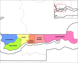
Lower Baddibu is one of the six districts of the North Bank Division of the Gambia. In the 2013 census, it had a population of 18,030.
Santa Cruz de la Mar Pequeña was a 15th century Spanish settlement close to Akhfennir, in the Tarfaya Province, in Morocco.

Carcaboso is a municipality located in the province of Cáceres, Extremadura, Spain. According to the 2012 census (INE), the municipality has a population of 1,137 inhabitants.

Bwiam, or Bwiam-Kankuntu, is a small town in southwestern Gambia. It is located in Foni Kansala District in the Western Division. As of 2009, it has an estimated population of 3,834.
Barrow Kunda is a town in the Gambia. It is located in Wuli District in the Upper River Division. According to tradition the village was founded in the 16th century by Alai Bah, a marabout from Futa Toro. The king of Wuli at the time, Mansa Jalali Wali convinced him to settle there by promising him autonomy to practice Islam and protection from search and seizure.
Amerzgane is a commune in the Ouarzazate Province of the Souss-Massa-Drâa administrative region of Morocco. At the time of the 2004 census, the commune had a total population of 7,593 people living in 1,290 households. However, these numbers have since grown; in the 2014 Moroccan census, Amerzgane had a total population of 8,820 people across 1,656 households. These numbers are composed almost entirely of native Moroccans, with the 2014 census reporting only one foreign citizen as a part of the population.
Lower Bambara Chiefdom is a chiefdom in Kenema District of Sierra Leone. Its capital is Baima.
Montpelier is a small village in Saint Philip Parish, Antigua and Barbuda.
