
Metamora is a village in Metamora Township, Woodford County, Illinois, United States. The population was 3,636 at the 2010 census. Metamora is a growing suburb of Peoria and is part of the Peoria, Illinois Metropolitan Statistical Area.
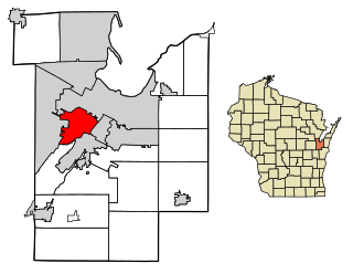
Ashwaubenon is a village in Brown County in the U.S. state of Wisconsin. The population was 16,991 at the 2020 census. A suburb of Green Bay, Ashwaubenon is part of the Green Bay Metropolitan Statistical Area and carries a Green Bay mailing address. Part of the Oneida Nation of Wisconsin is in Ashwaubenon.
Kheda is a city and a municipality in the Indian state of Gujarat. It was former administrative capital of Kheda district. India's First Deputy Prime Minister Vallabhbhai Patel Was Born In Kheda District of Gujarat State. Kheda city is famous for tobacco farming. The nearest railway station is Mahemadavad Kheda Road. The nearest airport is Ahmedabad airport. The nearest bus station is Kheda Bus Station.

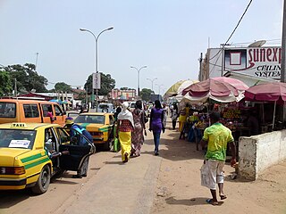
Bakau is a town on the Atlantic coast of Gambia, west of Gambia's capital city of Banjul. It is known for its botanical gardens, its crocodile pool Bakau Kachikally and for the beaches at Cape Point. Bakau is the first major suburb outside Banjul and the most developed town in the Gambia. Close to Bakau and Banjul is Gambia's largest city, Serekunda.
Kanifing is a municipality, local government area and district in the Gambia. It is part of the Greater Banjul Area, to the west of Banjul. It is governed by the Kanifing Municipal Council.

Central River is the largest of the five administrative divisions of the Gambia. Its capital is Janjanbureh, on MacCarthy Island. The largest settlement is Bansang, with an estimated population in 2008 of 8,381.
Kerewan is a town in the Gambia. Located beside the Miniminiyang Bolong, about 60 km from the capital Banjul. It is the seat of the Kerewan Local Government Area, located on the north bank of the lower river Gambia.
Kombo Central is one of the nine districts of the Gambia's Western Division, which is located to the south of the Gambia River in the southwest of the country. Kombo Central is in the southwest of the division, between Kombo East and Kombo South. In the 2013 census, it had a population of 142,831.
Kombo North/Saint Mary is one of the nine districts of the Gambia's Brikama Local Government Area, which is located to the south of the Gambia River in the southwest of the country. Kombo North/Saint Mary is in the northwest of the LGA, between Kombo South and Kanifing LGA. It is the only district in the LGA with coasts on both the Atlantic Ocean and the Gambia River, and is the most populated district in the LGA, with 344,756 inhabitants at the 2013 Census.
Kombo South is one of the nine districts of the Gambia's Western Division, which is located to the south of the Gambia River in the southwest of the country. Kombo South is in the southwest of the division, between Kombo Central and Kombo North/Saint Mary. In the 2013 census, it had a population of 108,773.

Niamina East is one of the ten districts of the Central River Division of the Gambia. Its population in the 2013 census was 24,571.
Upper Saloum is one of the ten districts of the Central River Division of the Gambia. In the 2013 census, it had a population of 19,145.

Kiang Central is one of the six districts of the Lower River Division of the Gambia. Along with Kiang East and Kiang West, it makes up the Kiang area. In the 2013 census, it had a population of 8,366.
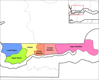
Jokadu is one of the six districts of the North Bank Division of the Gambia. In the 2013 census, it had a population of 22,132.
Chamkar Leu is a district (srok) of Kampong Cham province, Cambodia. The district capital is Chamkar Leu town. The town is located at the junction of National Roads 71 and 222 around 48 kilometres (30 mi) north east of the provincial capital at Kampong Cham city. The district is significant producer of rubber, both for domestic consumption and for export. Two large rubber co-operatives, Chamkar Andong Plantation and Chamkar Leu Plantation are located in the district. At 6,000 hectares, the state-owned Chamkar Andong plantation is one of the largest in the country.
Chol Kiri is a district (srok) in the east of Kampong Chhnang province, in central Cambodia. The district capital is Chol Kiri town located around eight km (5.0 mi) south of the provincial capital of Kampong Chhnang by road. Chol Kiri district is the easternmost district of Kampong Chhnang. The district shares a border with Kampong Thom and Kampong Cham provinces to the east. Most of the district is low lying floodplain and the Tonlé Sap River runs through the district roughly from north to south. This proximity to the river and the lack of high land make Chol Kiri one of the most flood prone districts in the country. The Kampong Chhnang Department of Development has estimated that both Chol Kiri and Kampong Leaeng districts are flooded for six months of the year and that after the floodwaters have receded drinking water sources are left contaminated.

Kampong Tralach is a district (srok) in the south east of Kampong Chhnang province, in central Cambodia. The district capital is Kampong Tralach town located 37 kilometres south of the provincial capital of Kampong Chhnang by road. The district shares a border with Kandal province to the south and Kampong Cham province to the east. The Tonlé Sap River runs through the district crossing roughly from north to south.
Pakali Ba is a riverside settlement in the Gambia. It is in the Jarra East area of the Lower River Division. Pakaliba is one of the earliest settlements of Jarra East. The founder was Kering Fenye Darboe who initially settled with his elder brother Abdou Kareem Darboe at Bureng. He was a hunter who used to travel towards the Sofainyama stream with his hunting dogs. The village is composed of four main clans called kabilo in Mandinka. These are Foday Kunda, Burang Kunda, Bantang Killing and Ceesay Kunda.

The Owensboro Metropolitan Statistical Area, as defined by the United States Census Bureau, is an area consisting of three counties in Kentucky, anchored by the city of Owensboro. As of the 2000 census, the MSA had a population of 109,875. In the 2010 Census the population was 114,752. Owensboro is part of the Illinois–Indiana–Kentucky tri-state area and sometimes, albeit seldom, referred to as Kentuckiana.
Marie Samuel Njie was a musician and singer, from, and popular in, The Gambia.
