Basse Santa Su | |
|---|---|
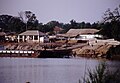
 Bridge at Basse | |
 Basse Santa Su Location in the Gambia | |
| Coordinates: 13°18′33″N14°13′09″W / 13.30917°N 14.21917°W | |
| Country | The Gambia |
| Division | Upper River Division |
| District | Fulladu East |
| Elevation | 68 ft (21 m) |
| Population | |
• Total | 18,414 |
| Time zone | UTC+00:00 (GMT) |
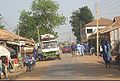
Basse Santa Su, usually known as Basse, is a town in the Gambia, lying on the south bank of the River Gambia. The easternmost major town in the nation, it is known for its important market. Basse is the capital of the Upper River Division, which is coterminous with the Basse Local Government Area. As of 2009, the town has an estimated population of 18,414. [1] According to the 2013 census, the Basse LGA has 243,791 residents. [2]
Contents
Famous people include Adama Barrow, the president of Gambia.