
The Gambia, officially the Republic of The Gambia, is a country in West Africa. It is the smallest country within mainland Africa and is surrounded by Senegal, except for its western coast on the Atlantic Ocean. The Gambia is situated on both sides of the lower reaches of the Gambia River, the nation's namesake, which flows through the centre of the Gambia and empties into the Atlantic Ocean, and elucidates the long shape of the country. It has an area of 11,300 square kilometres (4,400 sq mi) with a population of 1,857,181 as of the April 2013 census. Banjul is the Gambian capital and the country's largest metropolitan area, while the largest cities are Serekunda and Brikama.
The Senegambia is, in the narrow sense, a historical name for a geographical region in West Africa, which lies between the Senegal River in the north and the Gambia River in the south. However, there are also text sources which state that Senegambia is understood in a broader sense and equated with the term the Western region. This refers to the coastal areas between Senegal and Sierra Leone, where the inland border in the east was not further defined.

Kaolack is a town of 172,305 people on the north bank of the Saloum River and the N1 road in Senegal. It is the capital of the Kaolack Region, which borders The Gambia to the south. Kaolack is an important regional market town and is Senegal's main peanut trading and processing center. As the center of the Ibrahimiyya branch of the Tijaniyyah Sufi order founded by Ibrayima Ñas, it is also a major center of Islamic education. The Leona Niassene mosque (right) in Kaolack is one of the largest and best known in Senegal.

Serekunda is the largest urban centre in The Gambia. It is situated close to the Atlantic coast, 13 km (8 mi) south-west of the capital, Banjul, and is formed of nine villages which have grown together into a larger urban area.

Janjanbureh or Jangjangbureh is a town, founded in 1832, on Janjanbureh Island, also known as MacCarthy Island, in the Gambia River in eastern Gambia. Until 1995, it was known as Georgetown and was the second largest town in the country. It is the capital of Janjanbureh Local Government Area, and the Janjanbureh district. The population of the Janjanbureh LGA was 127,333 at the 2013 population census.
Kanifing is a town in the Gambia, and lies immediately west of the capital city of Banjul.

The Senegambian stone circles or the Wassu stone circles are groups of megalithic stone circles that lie in The Gambia north of Janjanbureh and in central Senegal. Spread across a region 30,000 km2 (12,000 sq mi), they are sometimes divided into the Wassu (Gambian) and Sine-Saloum (Senegalese) circles, but this is purely a national division. Containing over 1000 stone circles and tumuli spread across an area 350 km (220 mi) long and 100 km (62 mi) wide, the Senegambian stone circles are the largest concentration of stone circles seen anywhere in the world and an extensive sacred landscape that was used for more than 1500 years. As a result, the sites were inscribed on the UNESCO World Heritage List in 2006.

Paterson is a small township in the lower Hunter Region of New South Wales, Australia. Located within Dungog Shire, it is situated on the Paterson River. It is in the middle of what was once dairy, timber and citrus country and is now more significantly a feeder town for the nearby mining industry in the Upper Hunter and the city of Newcastle. It was named after one of the first known Europeans in the area was Colonel William Paterson in 1801 surveyed the area beside the river.

Sereď is a town in southern Slovakia near Trnava, on the right bank of the Váh River on the Danubian Lowland. It has approximately 15,500 inhabitants.
Kerewan is a town in the Gambia. Located beside the Miniminiyang Bolong, about 60 km from the capital Banjul. It is the seat of the Kerewan Local Government Area, located on the north bank of the lower river Gambia.

The Trans-Gambia Highway is a major highway in The Gambia, running across the centre of the nation in a north–south direction.
The Gambia is subdivided into 43 districts. They are listed below by Local Government Area, each with its population at the 15 April 2013 census.

The Gambia is divided into five administrative Regions and one City. The divisions of the Gambia are created by the Independent Electoral Commission in accordance to Article 192 of the National Constitution.
Kombo North/Saint Mary is one of the nine districts of the Gambia's Brikama Local Government Area, which is located to the south of the Gambia River in the southwest of the country. Kombo North/Saint Mary is in the northwest of the LGA, between Kombo South and Kanifing LGA. It is the only district in the LGA with coasts on both the Atlantic Ocean and the Gambia River, and is the most populated district in the LGA, with 344,756 inhabitants at the 2013 Census.
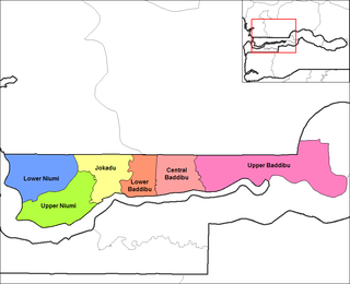
Upper Baddibu was one of the six districts of the North Bank Division of The Gambia. Its main town was Farafenni. The North Bank Division is now the Kerewan Local Government Area, and the former Upper Baddibu District is now divided into an Illiasa District and a Sabach Sanjal District. Its population in the 2003 census, prior to division, was 55,370.
The tourism industry today in the Gambia started when a party of 300 Swedish tourists arrived in 1965. That pioneering trip was organised by a Swede named Bertil Harding together with the tour operators Vingresor. It was seen as an ideal place to escape the harsh winter months of Scandinavia where Europeans would enjoy not only sun, sand and beaches but also experience the excitement of a real African holiday. It also offered a new opening for an affordable holiday to increasing numbers of traveling Europeans.

Bwiam, or Bwiam-Kankuntu, is a small town in southwestern Gambia. It is located in Foni Kansala District in the Western Division. As of 2009, it has an estimated population of 3,834.
Port Harcourt Local Government Area (PHALGA) is a local government area of Rivers State in southern Nigeria. It is one of the 23 local government areas created for the state. Its administrative seat is located in Port Harcourt. Although the local government consists of two different ethnic groups the Ikwerre and Obulom (Abuloma). The Abuloma people of Rivers State speak Obulom- Ochichi language.
The Kingdom of Niumi, also known as the Kingdom of Barra, was a West African nation at the Gambia River. Niumi was located at the mouth of the river, and extended nearly 60 kilometres (40 mi) along and north of its north bank. For much of its existence, its eastern border was occupied by the Kingdom of Baddibu, and its northern border was open savanna leading to Senegal. Formally becoming part of the Gambia Colony and Protectorate in 1897, the Kingdom now forms the Upper Niumi and Lower Niumi districts of the North Bank Division in The Gambia.

