

Lower Niumi is one of the six districts of the North Bank Division of the Gambia. In the 2013 census, it had a population of 57,358. [1]
Lower Niumi is one of the six districts of the North Bank Division of the Gambia. In the 2013 census, it had a population of 57,358. [1]

The Arctic Archipelago, also known as the Canadian Arctic Archipelago, is an archipelago lying to the north of the Canadian continental mainland, excluding Greenland and Iceland.
San Antonio Suchitepéquez is a town, with a population of 13,666, and a municipality in the Suchitepéquez department of Guatemala. The municipality is located at an elevation of 300 metres to 500 metres above sea level. It has a population of 59,184 and covers an area of 82.8 km².
Kerewan is a town in the Gambia. Located beside the Miniminiyang Bolong, about 60 km from the capital Banjul. It is the seat of the Kerewan Local Government Area, located on the north bank of the lower river Gambia.

Sukuta is a town located in the Western Division of the Gambia. It had a population of 16,667 as of the 1993 census.
Albertville is a village in the Canadian province of Saskatchewan within the Rural Municipality of Wise Creek No. 77 and Census Division No. 15. It is approximately 25 km northeast of the City of Prince Albert.
Kombo Central is one of the nine districts of the Gambia's Western Division, which is located to the south of the Gambia River in the southwest of the country. Kombo Central is in the southwest of the division, between Kombo East and Kombo South. In the 2013 census, it had a population of 142,831.
Kombo North/Saint Mary is one of the nine districts of the Gambia's Brikama Local Government Area, which is located to the south of the Gambia River in the southwest of the country. Kombo North/Saint Mary is in the northwest of the LGA, between Kombo South and Kanifing LGA. It is the only district in the LGA with coasts on both the Atlantic Ocean and the Gambia River, and is the most populated district in the LGA, with 344,756 inhabitants at the 2013 Census.
Kombo South is one of the nine districts of the Gambia's Western Division, which is located to the south of the Gambia River in the southwest of the country. Kombo South is in the southwest of the division, between Kombo Central and Kombo North/Saint Mary. In the 2013 census, it had a population of 108,773.

Niamina East is one of the ten districts of the Central River Division of the Gambia. Its population in the 2013 census was 24,571.

Jarra Central is one of the six districts of the Lower River Division of the Gambia. In the 2013, it had a population of 8,437.
Jarra East is one of the six districts of the Lower River Division of the Gambia. In the 2013 census, it had a population of 16,551.
Jarra West is one of the six districts of the Lower River Division of the Gambia. In the 2013 census, it had a population of 27,205.
Kiang Central is one of the six districts of the Lower River Division of the Gambia. Along with Kiang East and Kiang West, it makes up the Kiang area. In the 2013 census, it had a population of 8,366.
Kiang East is one of the six districts of the Lower River Division of the Gambia. Along with Kiang Central and Kiang West, it makes up the Kiang area. In the 2013 census, it had a population of 6,849.
Kiang West is one of the six districts of the Lower River Division of the Gambia. Along with Kiang Central and Kiang East, it makes up the Kiang area. In the 2013 census, it had a population of 14,953.
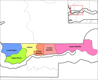
Central Baddibu is one of the six districts of the North Bank Division of the Gambia. In the 2013 census, it had a population of 20,104.
Jokadu is one of the six districts of the North Bank Division of the Gambia. In the 2013 census, it had a population of 22,132.
Lower Baddibu is one of the six districts of the North Bank Division of the Gambia. In the 2013 census, it had a population of 18,030.

Sandu District is one of the four districts of the Upper River Division of the Republic of the Gambia. It contains the town of Diabugu.

Quintanapalla is a municipality and town located in the province of Burgos, Castile and León, Spain. According to the 2004 census (INE), the municipality has a population of 116 inhabitants.
| Local Government Areas | |||||||||||||
|---|---|---|---|---|---|---|---|---|---|---|---|---|---|
| National capital, Divisions and Districts |
| ||||||||||||
Coordinates: 13°32′N16°25′W / 13.533°N 16.417°W
| | This Gambian location article is a stub. You can help Wikipedia by expanding it. |