
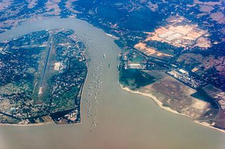
Banjul, officially the City of Banjul, is the capital of The Gambia. It is the centre of the eponymous administrative division which is home to an estimated 400,000 residents, making it The Gambia's largest and most densely populated metropolitan area. The city Banjul is located on St Mary's Island, where the Gambia River enters the Atlantic Ocean.
The Karnaphuli River is the largest and most important river in Chittagong and the Chittagong Hill Tracts. It is a 667-metre (2,188 ft) wide river in the south-eastern part of Bangladesh. Originating from the Saithah village of Mamit district in Mizoram, India, it flows 270 kilometres (170 mi) southwest through Chattogram Hill Tracts and Chattogram into the Bay of Bengal. It is the fastest flowing river in Bangladesh, after the Padma. It is said to "represent the drainage system of the whole south-western part of Mizoram." Principal tributaries include the Kawrpui River or Thega River, Tuichawng River and Phairuang River. A large hydroelectric power plant was built on the Karnaphuli in the Kaptai region in the 1960s. The mouth of the river hosts the Port of Chattogram, the largest and busiest seaport of Bangladesh.

Basse Santa Su, usually known as Basse, is a town in the Gambia, lying on the south bank of the River Gambia. The easternmost major town in the nation, it known for its important market. Basse is the capital of the Upper River Division, which is coterminous with the Basse Local Government Area. As of 2009, the town has an estimated population of 18,414. According to the 2013 census, the Basse LGA has 243,791 residents.

West Coast Region, originally the Western Division, also known as Foni or Fonyi, was one of the five administrative divisions of the Gambia. Its capital was Brikama. It was subsequently reorganised as the Brikama Local Government Area (LGA), without any change in the area covered.
The Gambia is subdivided into 43 districts. They are listed below by Local Government Area, each with its population at the 15 April 2013 census.
The Gambia is divided into five administrative Regions and one City. The divisions of the Gambia are created by the Independent Electoral Commission in accordance to Article 192 of the National Constitution.

Foni Bintang-Karenai is one of the nine districts of the Gambia's Western Division, which is located to the south of the Gambia River in the southwest of the country. Foni Bintang-Karenai is in the central south of the division, between Foni Kansala and Foni Brefet.
Foni Bondali is one of the nine districts of the Gambia's Western Division, which is located to the south of the Gambia River in the southwest of the country. Foni Bondali is in the southeast of the division, between Foni Kansala and Foni Jarrol.
Foni Brefet is one of the nine districts of the Gambia's Western Division, which is located to the south of the Gambia River in the southwest of the country. Foni Brefet is in the center of the division, between Kombo East and Foni Bintang-Karenai.
Foni Kansala is one of the nine districts of the Gambia's West Coast Region, which is located to the south of the Gambia River in the southwest of the country. Foni Kansala is in the southeast of the division, between Foni Bintang-Karenai and Foni Bondali.
Kombo Central is one of the nine districts of the Gambia's Western Division, which is located to the south of the Gambia River in the southwest of the country. Kombo Central is in the southwest of the division, between Kombo East and Kombo South. In the 2013 census, it had a population of 142,831.
Kombo North/Saint Mary is one of the nine districts of the Gambia's Brikama Local Government Area, which is located to the south of the Gambia River in the southwest of the country. Kombo North/Saint Mary is in the northwest of the LGA, between Kombo South and Kanifing LGA. It is the only district in the LGA with coasts on both the Atlantic Ocean and the Gambia River, and is the most populated district in the LGA, with 344,756 inhabitants at the 2013 Census.
Kombo South is one of the nine districts of the Gambia's Western Division, which is located to the south of the Gambia River in the southwest of the country. Kombo South is in the southwest of the division, between Kombo Central and Kombo North/Saint Mary. In the 2013 census, it had a population of 108,773.

Lower Saloum is one of the ten districts of the Central River Division of the Gambia. Its population in the 2013 census was 15,881.
Niamina East is one of the ten districts of the Central River Division of the Gambia. Its population in the 2013 census was 24,571.

Kiang Central is one of the six districts of the Lower River Division of the Gambia. Along with Kiang East and Kiang West, it makes up the Kiang area. In the 2013 census, it had a population of 8,366.
Kiang East is one of the six districts of the Lower River Division of the Gambia. Along with Kiang Central and Kiang West, it makes up the Kiang area. In the 2013 census, it had a population of 6,849.
Kiang West is one of the six districts of the Lower River Division of the Gambia. Along with Kiang Central and Kiang East, it makes up the Kiang area. In the 2013 census, it had a population of 14,953.
The tourism industry today in the Gambia started when a party of 300 Swedish tourists arrived in 1965. That pioneering trip was organised by a Swede named Bertil Harding together with the tour operators Vingresor. It was seen as an ideal place to escape the harsh winter months of Scandinavia where Europeans would enjoy not only sun, sand and beaches but also experience the excitement of a real African holiday. It also offered a new opening for an affordable holiday to increasing numbers of traveling Europeans.
Kombo was a territory and kingdom in Gambia during the colonial period.
