
Sami District is one of the districts of the Central River Division of the Gambia. In the 2013 census, it had a population of 24,429. [1]
Sami District is one of the districts of the Central River Division of the Gambia. In the 2013 census, it had a population of 24,429. [1]

Central River was the largest of the five administrative divisions of the Gambia. Its capital was Janjanbureh, on MacCarthy Island. The largest settlement was Bansang, with an estimated population in 2008 of 8,381.
Kombo Central is one of the nine districts of the Gambia's Western Division, which is located to the south of the Gambia River in the southwest of the country. Kombo Central is in the southwest of the division, between Kombo East and Kombo South. In the 2013 census, it had a population of 142,831.
Kombo North/Saint Mary is one of the nine districts of the Gambia's Brikama Local Government Area, which is located to the south of the Gambia River in the southwest of the country. Kombo North/Saint Mary is in the northwest of the LGA, between Kombo South and Kanifing LGA. It is the only district in the LGA with coasts on both the Atlantic Ocean and the Gambia River, and is the most populated district in the LGA, with 344,756 inhabitants at the 2013 Census.
Kombo South is one of the nine districts of the Gambia's Western Division, which is located to the south of the Gambia River in the southwest of the country. Kombo South is in the southwest of the division, between Kombo Central and Kombo North/Saint Mary. In the 2013 census, it had a population of 108,773.

Lower Saloum is one of the ten districts of the Central River Division of the Gambia. Its population in the 2013 census was 15,881.
Niamina Dankunku is one of the ten districts of the Central River Division of the Gambia.
Niamina East is one of the ten districts of the Central River Division of the Gambia. Its population in the 2013 census was 24,571.
Niamina West is one of the ten districts of the Central River Division in the Gambia. In the 2013 census, it had a population of 7,293.
Upper Saloum is one of the ten districts of the Central River Division of the Gambia. In the 2013 census, it had a population of 19,145.

Jarra East is one of the six districts of the Lower River Division of the Gambia. In the 2013 census, it had a population of 16,551.
Jarra West is one of the six districts of the Lower River Division of the Gambia. In the 2013 census, it had a population of 27,205.
Kiang Central is one of the six districts of the Lower River Division of the Gambia. Along with Kiang East and Kiang West, it makes up the Kiang area. In the 2013 census, it had a population of 8,366.
Kiang East is one of the six districts of the Lower River Division of the Gambia. Along with Kiang Central and Kiang West, it makes up the Kiang area. In the 2013 census, it had a population of 6,849.
Kiang West is one of the six districts of the Lower River Division of the Gambia. Along with Kiang Central and Kiang East, it makes up the Kiang area. In the 2013 census, it had a population of 14,953.
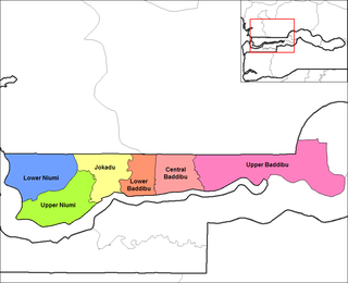
Central Baddibu is one of the six districts of the North Bank Division of the Gambia. In the 2013 census, it had a population of 20,104.
Jokadu is one of the six districts of the North Bank Division of the Gambia. In the 2013 census, it had a population of 22,132.
Lower Baddibu is one of the six districts of the North Bank Division of the Gambia. In the 2013 census, it had a population of 18,030.
Lower Niumi is one of the six districts of the North Bank Division of the Gambia. In the 2013 census, it had a population of 57,358.
Upper Baddibu was one of the six districts of the North Bank Division of The Gambia. Its main town was Farafenni. The North Bank Division is now the Kerewan Local Government Area, and the former Upper Baddibu District is now divided into an Illiasa District and a Sabach Sanjal District. Its population in the 2003 census, prior to division, was 55,370.

Fulladu East was one of the four districts of the Upper River Division of the Gambia. The Upper River Division is now the Basse Local Government Area, and the former Fulladu East District is now divided into a Basse Fulladu East District, a Jimara District and a Tumana District.
| Local Government Areas | |||||||||||||
|---|---|---|---|---|---|---|---|---|---|---|---|---|---|
| National capital, Divisions and Districts |
| ||||||||||||
Coordinates: 13°35′N14°35′W / 13.583°N 14.583°W
| | This Gambian location article is a stub. You can help Wikipedia by expanding it. |