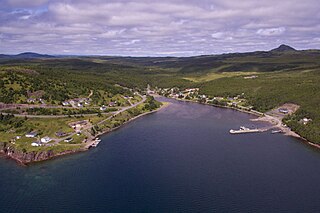
Sunnyside is a town on the Avalon Peninsula in Newfoundland and Labrador, Canada. It is in Division 1 on Bull Arm.

Basse Santa Su, usually known as Basse, is a town in the Gambia, lying on the south bank of the River Gambia. The easternmost major town in the nation, it known for its important market. Basse is the capital of the Upper River Division, which is coterminous with the Basse Local Government Area. As of 2009, the town has an estimated population of 18,414. According to the 2013 census, the Basse LGA has 243,791 residents.

Central River is the largest of the five administrative divisions of the Gambia. Its capital is Janjanbureh, on MacCarthy Island. The largest settlement is Bansang, with an estimated population in 2008 of 8,381.

West Coast Region, originally the Western Division, also known as Foni or Fonyi, was one of the five administrative divisions of the Gambia. Its capital was Brikama. It was subsequently reorganised as the Brikama Local Government Area (LGA), without any change in the area covered.
Bintanding Jarju is a former member of the Pan-African Parliament of the African Union from the Gambia. She is the former member of the National Assembly for Foni Brefet.
The Gambia is subdivided into 43 districts. They are listed below by Local Government Area, each with its population at the 15 April 2013 census.
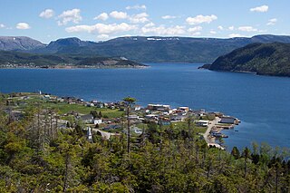
Woody Point is a town located in the heart of Gros Morne National Park, on the western coast of Newfoundland. Situated on Bonne Bay, the Town of Woody Point encompasses three areas: Curzon Village, Woody Point and Winterhouse Brook. It has a total population of 244 residents. Woody Point is a Registered Heritage District and has a waterfront with many heritage buildings and four Registered Newfoundland and Labrador Heritage Structures. The community is served by Route 431.

Vyšný Kazimír is a village and municipality in Vranov nad Topľou District in the Prešov Region of eastern Slovakia.

The River Nagavali also known as Langulya is one of the main rivers of Southern Odisha and Andhra States in India, between Rushikulya and Godavari basins.

Foni Bintang-Karenai is one of the nine districts of the Gambia's Western Division, which is located to the south of the Gambia River in the southwest of the country. Foni Bintang-Karenai is in the central south of the division, between Foni Kansala and Foni Brefet.
Foni Brefet is one of the nine districts of the Gambia's Western Division, which is located to the south of the Gambia River in the southwest of the country. Foni Brefet is in the center of the division, between Kombo East and Foni Bintang-Karenai.
Foni Jarrol is one of the nine districts of the Gambia's Western Division, which is located to the south of the Gambia River in the southwest of the country. Foni Jarrol is in the far east of the division, between Foni Bondali and the border with Senegal.
Foni Kansala is one of the nine districts of the Gambia's West Coast Region, which is located to the south of the Gambia River in the southwest of the country. Foni Kansala is in the southeast of the division, between Foni Bintang-Karenai and Foni Bondali.
Kombo East is one of the nine districts of the Gambia's Western Division, which is located to the south of the Gambia River in the southwest of the country. Kombo East is in the central south of the division, between Kombo Central and Foni Brefet.

EUCLID, also called Pôle Universitaire Euclide or Euclid University, is an international intergovernmental organization with a university charter established in 2008. It has official headquarters in The Gambia and in the Central African Republic, but also maintains an executive office in Washington, D.C. Its primary mandate is to train officials for its participating states, but its programs are also offered to the general public. The institution's current secretary-general is Winston Dookeran.
Barrow Kunda is a town in the Gambia. It is located in Wuli District in the Upper River Division. According to tradition the village was founded in the 16th century by Alai Bah, a marabout from Futa Toro. The king of Wuli at the time, Mansa Jalali Wali convinced him to settle there by promising him autonomy to practice Islam and protection from search and seizure.
Ain Taoujdate is a city in El Hajeb Province, Fès-Meknès, Morocco. It is located roughly halfway between the cities of Fez and Meknes and is serviced by the national ONCF train line. According to the 2004 census, it had a population of 22,030.

Lagunes District is one of fourteen administrative districts of Ivory Coast. The district is located in the southern part of the country. The capital of the district is Dabou.

The Giftun Islands are two islands in the Red Sea near Hurghada in Egypt. Giftun Kebir or Big Giftun is located further west and closer to Hurghada. Giftun Soraya or Little Giftun is further east.
