
The Arctic Archipelago, also known as the Canadian Arctic Archipelago, is an archipelago lying to the north of the Canadian continental mainland, excluding Greenland.

Serekunda is the largest urban centre in The Gambia. It is situated close to the Atlantic coast, 13 km (8 mi) south-west of the capital, Banjul, and is formed of nine villages which have grown together into a larger urban area.

Basse Santa Su, usually known as Basse, is a town in the Gambia, lying on the south bank of the River Gambia. The easternmost major town in the nation, it known for its important market. Basse is the capital of the Upper River Division, which is coterminous with the Basse Local Government Area. As of 2009, the town has an estimated population of 18,414. According to the 2013 census, the Basse LGA has 243,791 residents.

Central River was the largest of the five administrative divisions of the Gambia. Its capital was Janjanbureh, on MacCarthy Island. The largest settlement was Bansang, with an estimated population in 2008 of 8,381.

North Bank was one of the five administrative divisions of the Gambia. Its capital was Kerewan. It was subsequently reorganised as the Kerewan Local Government Area (LGA), without any change in the area covered.

Upper River was one of the five Divisions of the Gambia. Its capital was Basse Santa Su. It was subsequently reorganised as the Basse Local Government Area, without any change in the area covered.

West Coast Region, originally the Western Division, also known as Foni or Fonyi, was one of the five administrative divisions of the Gambia. Its capital was Brikama. It was subsequently reorganised as the Brikama Local Government Area (LGA), without any change in the area covered.
Kuntaur is a town located in central part of the Gambia.
The Gambia is subdivided into 43 districts. They are listed below by Local Government Area, each with its population at the 15 April 2013 census.
Kombo Central is one of the nine districts of the Gambia's Western Division, which is located to the south of the Gambia River in the southwest of the country. Kombo Central is in the southwest of the division, between Kombo East and Kombo South. In the 2013 census, it had a population of 142,831.
Kombo North/Saint Mary is one of the nine districts of the Gambia's Brikama Local Government Area, which is located to the south of the Gambia River in the southwest of the country. Kombo North/Saint Mary is in the northwest of the LGA, between Kombo South and Kanifing LGA. It is the only district in the LGA with coasts on both the Atlantic Ocean and the Gambia River, and is the most populated district in the LGA, with 344,756 inhabitants at the 2013 Census.
Kombo South is one of the nine districts of the Gambia's Western Division, which is located to the south of the Gambia River in the southwest of the country. Kombo South is in the southwest of the division, between Kombo Central and Kombo North/Saint Mary. In the 2013 census, it had a population of 108,773.

Upper Saloum is one of the ten districts of the Central River Division of the Gambia. In the 2013 census, it had a population of 19,145.
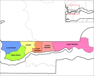
Central Baddibu is one of the six districts of the North Bank Division of the Gambia. In the 2013 census, it had a population of 20,104.
Jokadu is one of the six districts of the North Bank Division of the Gambia. In the 2013 census, it had a population of 22,132.
Lower Baddibu is one of the six districts of the North Bank Division of the Gambia. In the 2013 census, it had a population of 18,030.
Lower Niumi is one of the six districts of the North Bank Division of the Gambia. In the 2013 census, it had a population of 57,358.

Fulladu East was one of the four districts of the Upper River Division of the Gambia. The Upper River Division is now the Basse Local Government Area, and the former Fulladu East District is now divided into a Basse Fulladu East District, a Jimara District and a Tumana District.
Bambali is a town in eastern Gambia. It is located in Upper Baddibu District in the North Bank Division. As of 2012, it has an estimated population of 1,264.
Bantango Koto is a village in the Gambia. It is located in Wuli District in the Upper River Division. As of 2009, it has an estimated population of 327.
