
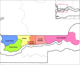
Upper Niumi is one of the six districts of the North Bank Division of the Gambia which is located in West Africa [1] The remaining five districts are: Lower Niumi, Jokadu, Lower Baddibu, Central Baddibu and Upper Baddibu.
Upper Niumi is one of the six districts of the North Bank Division of the Gambia which is located in West Africa [1] The remaining five districts are: Lower Niumi, Jokadu, Lower Baddibu, Central Baddibu and Upper Baddibu.

The Gambia is a very small and narrow African country with the border based on the Gambia River. The country is less than 48 kilometres (30 mi) wide at its greatest width. The country's present boundaries were defined in 1889 after an agreement between the United Kingdom and France. It is often claimed by Gambians that the distance of the borders from the Gambia River corresponds to the area that British naval cannon of the time could reach from the river's channel. However, there is no historical evidence to support the story, and the border was actually delineated using careful surveying methods by the Franco-British boundary commission. The Gambia is almost an enclave of Senegal and is the smallest country on mainland Africa.

The Gambia River is a major river in West Africa, running 1,120 kilometres (700 mi) from the Fouta Djallon plateau in north Guinea westward through Senegal and The Gambia to the Atlantic Ocean at the city of Banjul. It is navigable for about half that length.

Albreda is a historic settlement in the Gambia on the north bank of the Gambia River, variously described as a 'trading post' or a 'slave fort'. It is located near Jufureh in the North Bank Division and an arch stands on the beach connecting the two places. As of 2008, it has an estimated population of 1,776.

Jufureh is a town in the Gambia, 30 kilometers inland on the north bank of the River Gambia in the North Bank Division near James Island. The town is home to a museum and Fort Jillifree.
Kanilai is a village in southern Gambia, near the border with Senegal. The former president of The Gambia, Yahya Jammeh, was born in this village and expanded it after coming to power. Previously, the town had been a quiet backwater, home to small-scale maize and groundnut farmers and little else. It is now home to a presidential palace, a wrestling arena, a luxury hotel and a game park and zoo. The zoo, which Jammeh said would allow Gambians to "experience African wildlife", was unsuccessful at first, with animals dying due to hunting, predation and insufficient food.
Nuno Tristão was a 15th-century Portuguese explorer and slave trader, active in the early 1440s, traditionally thought to be the first European to reach the region of Guinea.

Barra, traditionally known as Niumi, is a city in The Gambia, located in the district of Lower Niumi. The predominant languages of the city are Serer and Wolof.

North Bank was one of the five administrative divisions of the Gambia. Its capital was Kerewan. It was subsequently reorganised as the Kerewan Local Government Area (LGA), without any change in the area covered.
The Gambia is subdivided into 43 districts. They are listed below by Local Government Area, each with its population at the 15 April 2013 census.
Foni Brefet is one of the nine districts of the Gambia's Western Division, which is located to the south of the Gambia River in the southwest of the country. Foni Brefet is in the center of the division, between Kombo East and Foni Bintang-Karenai.

Kiang Central is one of the six districts of the Lower River Division of the Gambia. Along with Kiang East and Kiang West, it makes up the Kiang area. In the 2013 census, it had a population of 8,366.
Kiang West is one of the six districts of the Lower River Division of the Gambia. Along with Kiang Central and Kiang East, it makes up the Kiang area. In the 2013 census, it had a population of 14,953.
Lower Baddibu is one of the six districts of the North Bank Division of the Gambia. In the 2013 census, it had a population of 18,030.
Lower Niumi is one of the six districts of the North Bank Division of the Gambia. In the 2013 census, it had a population of 57,358.
Upper Baddibu was one of the six districts of the North Bank Division of The Gambia. Its main town was Farafenni. The North Bank Division is now the Kerewan Local Government Area, and the former Upper Baddibu District is now divided into an Illiasa District and a Sabach Sanjal District. Its population in the 2003 census, prior to division, was 55,370.

Fulladu East was one of the four districts of the Upper River Division of the Gambia. The Upper River Division is now the Basse Local Government Area, and the former Fulladu East District is now divided into a Basse Fulladu East District, a Jimara District and a Tumana District.
Bakindick Mandinka is a town in western Gambia. It is located in Lower Niumi District in the North Bank Division. As of 2008, it has an estimated population of 1,801.
The Niominka people are an ethnic group in Senegal living on the islands of the Saloum River delta. They are currently classified as a subgroup of the Serer.
Essau is a small town in north-western Gambia. It is located in Lower Niumi District in the North Bank Division. As of 2009, it has an estimated population of 6,670.
The Kingdom of Niumi, also known as the Kingdom of Barra, was a West African nation at the Gambia River. Niumi was located at the mouth of the river, and extended nearly 60 kilometres (40 mi) along and north of its north bank. For much of its existence, its eastern border was occupied by the Kingdom of Baddibu, and its northern border was open savanna leading to Senegal. Formally becoming part of the Gambia Colony and Protectorate in 1897, the Kingdom now forms the Upper Niumi and Lower Niumi districts of the North Bank Division in The Gambia.
| Local Government Areas | |||||||||||||
|---|---|---|---|---|---|---|---|---|---|---|---|---|---|
| National capital, Divisions and Districts |
| ||||||||||||
Coordinates: 13°24′N16°20′W / 13.400°N 16.333°W
| | This Gambian location article is a stub. You can help Wikipedia by expanding it. |