Bansed

Last updated

Bansed
Village
India Rajasthan location map.svg
Red pog.svg
Bansed
Location in Rajasthan, India
India location map.svg
Red pog.svg
Bansed
Bansed (India)
Coordinates: 26°38′N74°37′E / 26.63°N 74.62°E / 26.63; 74.62 Coordinates: 26°38′N74°37′E / 26.63°N 74.62°E / 26.63; 74.62
CountryFlag of India.svg  India
State Rajasthan
District Nagaur
Elevation
223 m (732 ft)
Population
(2011)
  Total1,459
Languages
  Official Hindi
Time zone UTC+5:30 (IST)
PIN
341512
Telephone code01587
ISO 3166 code RJ-IN
Vehicle registration RJ 21

Bansed is a village in Parbatsar tehsil in Nagaur District of Rajasthan.

Parbatsar city in Rajasthan, India

Parbatsar is a town and a municipality in Nagaur district in the Indian state of Rajasthan.

Rajasthan State in India

Rajasthan is a state in northern India. The state covers an area of 342,239 square kilometres (132,139 sq mi) or 10.4 percent of the total geographical area of India. It is the largest Indian state by area and the seventh largest by population. Rajasthan is located on the northwestern side of India, where it comprises most of the wide and inhospitable Thar Desert and shares a border with the Pakistani provinces of Punjab to the northwest and Sindh to the west, along the Sutlej-Indus river valley. Elsewhere it is bordered by five other Indian states: Punjab to the north; Haryana and Uttar Pradesh to the northeast; Madhya Pradesh to the southeast; and Gujarat to the southwest.

Contents

Geography

Bansed is located at 26°38′N74°37′E / 26.63°N 74.62°E / 26.63; 74.62 . [1]

Demographics

As of 2011 India census, [2] Bansed had a population of 1,459. Males constitute 741 of the population and females 718. [3]

Census Acquiring and recording information about the members of a given population

A census is the procedure of systematically acquiring and recording information about the members of a given population. The term is used mostly in connection with national population and housing censuses; other common censuses include agriculture, business, and traffic censuses. The United Nations defines the essential features of population and housing censuses as "individual enumeration, universality within a defined territory, simultaneity and defined periodicity", and recommends that population censuses be taken at least every 10 years. United Nations recommendations also cover census topics to be collected, official definitions, classifications and other useful information to co-ordinate international practice.

Related Research Articles

Partapur, Rajasthan City in Rajasthan, India

Partapur is a town in Banswara District

Jangipur(WB) City in West Bengal, India

Jangipur is a city and a municipality in Murshidabad district in the state of West Bengal, India. It is the headquarters of the Jangipur subdivision. It is situated on the banks of the Bhagirathi. The city is said to have been founded by the Mughal emperor Jahangir. That is why this city also known as Jahangirpur. During the early years of British rule it was an important centre of the silk trade, and the site of one of the East India Company's commercial residencies.

Bhilwara district district of Rajasthan, India

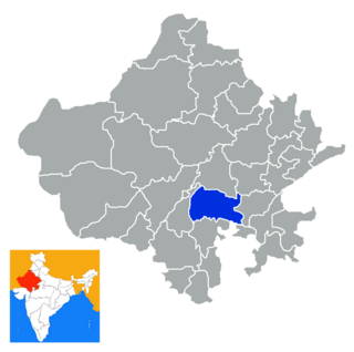
Bhilwara District is a district of the state of Rajasthan in western India. The town of Bhilwara is the district headquarters.

Bishnah town in Jammu and Kashmir, India

Bishnah is a town and a notified area committee in Jammu district in the state of Jammu & Kashmir, India.

Chikiti City in Odisha, India

Chikiti is a town and a notified area committee located in Ganjam district in the state of Odisha, India.

Kalaghatagi Town/Taluka in Karnataka, India

Kalaghatagi is an administrative division, or Taluka, in the Dharwad district of the Indian state of Karnataka.

Kiranipura is a census town in Ajmer district in the Indian state of Rajasthan.

Kunzer city in Jammu and Kashmir, Gulmarg India

Kunzer is a city in India. It is only 7km from Gulmarg.

Londa, Karnataka Town in Karnataka, India

Londa is a census town in Belgaum district in the Indian state of Karnataka.The town is on border with state of Goa. The town is surrounded by lush evergreen forests known as Sahayadri or Western ghats of India. Londa Junction railway station is located on the Belgaum - Goa railway route.

Maheshtala Neighbourhood in Kolkata in Presidency, West Bengal, India

Maheshtala is a city and a municipality of South 24 Parganas district in the Indian State of West Bengal. It is a part of the area covered by Kolkata Metropolitan Development Authority (KMDA).

Rahuri Town in Maharashtra, India

Rahuripronunciation  is a town and a municipal council in Ahmednagar district in the Indian state of Maharashtra.

Ranapur city in Madhya Pradesh, India

Ranapur is a town and a nagar panchayat in Jhabua district in the Indian state of Madhya Pradesh.

Tentulkuli Census Town in West Bengal, India

Tentulkuli is a census town in Domjur CD Block of Howrah Sadar subdivision in Howrah district in the Indian state of West Bengal.

Vasudevanallur panchayat town in Tamil Nadu, India

Vasudevanallur is a panchayat town in Tirunelveli district in the Indian state of Tamil Nadu.

Manpur, Indore city in Madhya Pradesh, India

Manpur is a town and a nagar panchayat in Mhow Tehsil of Indore district in the Indian state of Madhya Pradesh.

Hata, India Town in Uttar Pradesh, India

Hata is a town having 25 wards and a Nagarpalika in Kushinagar district in the Indian state of Uttar Pradesh. It is situated 36 km away from Gorakhpur in east. It is a major town of Kushinagar district situated on NH -28. Nearest railway station is Gauri Bajar, which is 17 km away from the town and the next major market of Kaptanganj is located 23 km away from it. The gram panchayat of Dhadha Bujurg is located 3 km west from the town. Hata is the main market for wholesaler, local vendors & retailers.

Amta I Historical City in West Bengal, India

Amta I is a city and community development block that forms an administrative division in Uluberia subdivision of Howrah district in the Indian state of West Bengal.

Panchla (community development block) Community development block in West Bengal, India

Panchla is a community development block that forms an administrative division in Howrah Sadar subdivision of Howrah district in the Indian state of West Bengal.

Chanki, Bihar Village in Bihar, India

Chanki is a village in West Champaran district in the Indian state of Bihar.

Korahalli Village in Karnataka, India

Korhalli is a large village located in Sindagi Taluk in Bijapur District of Karnataka State, India.

References

  1. Flickr Geo API Explorer: Bansed
  2. "Census of India 2001: Data from the 2001 Census, including cities, villages and towns (Provisional)". Census Commission of India. Archived from the original on 2004-06-16. Retrieved 2008-11-01.
  3. Bansed on Censusindia.gov.in