Related Research Articles

Clay County is a county in the U.S. state of South Dakota. As of the 2010 United States Census, the population was 13,864. The county seat is Vermillion, which is also home to the University of South Dakota. The county is named for Henry Clay, American statesman, US Senator from Kentucky, and United States Secretary of State in the 19th century.

Dakota County is the third-most populous county in the U.S. state of Minnesota, located in the east central portion of the state. As of the 2010 United States Census, the population was 398,552. The county seat is Hastings. Dakota County is named for the Dakota Sioux tribal bands who inhabited the area. The name is recorded as "Dahkotah" in the United States Census records until 1851. Dakota County is included in the Minneapolis–St. Paul–Bloomington, MN–WI Metropolitan Statistical Area, the sixteenth largest metropolitan area in the United States with about 3.64 million residents. The largest city in Dakota County is the city of Lakeville, the eleventh-largest city in Minnesota and sixth-largest Twin Cities suburb. The county is bordered by the Minnesota and Mississippi Rivers on the north, and the state of Wisconsin on the east.

Vermillion County lies in the western part of the U.S. state of Indiana between the Illinois border and the Wabash River. As of the 2010 census, the population was 16,212. The county seat is Newport. It was officially established in 1824 and was the fiftieth Indiana county to be formed.

Vermillion is a city in and the county seat of Clay County. It is located in the southeastern corner of South Dakota, United States and is the eleventh largest city in the state. According to the 2010 Census, the population was 10,571. The city lies atop a bluff near the Missouri River.

Hastings is a city in Dakota and Washington counties, in the U.S. state of Minnesota, near the confluence of the Mississippi, Vermillion, and St. Croix Rivers. Its population was 22,172 at the 2010 census. It is the county seat of Dakota County, which contains most of it; a small part extends into Washington County along the Mississippi River's north bank. It is named for the first elected governor of Minnesota, Henry Hastings Sibley.
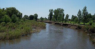
The Vermillion River is a tributary of the Missouri River, 96 miles (154 km) long, in eastern South Dakota in the United States. The origin of the river name is Waséoyuze, Lakota for "place where Vermilion is obtained".
Vermilion is a red pigment and color.

Lake Oahe is a large reservoir behind Oahe Dam on the Missouri River; it begins in central South Dakota and continues north into North Dakota in the United States. The lake has an area of 370,000 acres (1,500 km2) and a maximum depth of 205 ft (62 m). By volume, it is the fourth-largest reservoir in the US. Lake Oahe has a length of approximately 231 mi (372 km) and has a shoreline of 2,250 mi (3,620 km). 51 recreation areas are located along Lake Oahe, and 1.5 million people visit the reservoir every year. The lake is named for the 1874 Oahe Indian Mission.

Glencross is an unincorporated community in Dewey County in the U.S. state of South Dakota. It is located within the Cheyenne River Indian Reservation.
Meckling is an unincorporated community in Clay County, South Dakota, United States. Although not tracked by the Census Bureau.

The Crow Creek Indian Reservation is located in parts of Buffalo, Hughes, and Hyde counties on the east bank of the Missouri River in central South Dakota in the United States. It has a land area of 421.658 square miles (1,092.09 km2) and a 2000 census population of 2,225 persons. The major town and capital of the Crow Creek Sioux Tribe is Fort Thompson.

The Missouri National Recreational River is a National Recreational River located on the border between Nebraska and South Dakota. The designation was first applied in 1978 to a 59-mile section of the Missouri River between Gavins Point Dam and Ponca State Park. In 1991, an additional 39-mile section between Fort Randall Dam and Niobrara, Nebraska, was added to the designation. These two stretches of the Missouri River are the only parts of the river between Montana and the mouth of the Missouri that remain undammed or unchannelized. The last 20 miles of the Niobrara River and 6 miles of Verdigre Creek were also added in 1991.

South Dakota Highway 19 (SD 19) is a 86.974-mile (139.971 km) state highway in southeastern South Dakota, United States. It connects the Nebraska state line, south of Vermillion, with the southeastern part of the Madison area, via Viborg, Hurley, Parker, and Humboldt. SD 19 formerly entered Centerville, but was shifted to the south. Its former path was redesignated as SD 19A. Its former southern terminus was at Vermillion, but was extended when a new bridge from Nebraska opened.
White Owl is an unincorporated rural village in east central Meade County, South Dakota, United States, with a population of 61 as of the 2010 census. It lies along Highway 34, 55 miles (89 km) east of the city of Sturgis, the county seat and was established in 1890, and opened as the first post office in Meade County in 1893. Its elevation is 2,792 feet (851 m). The village has a fashion boutique, a Baptist church, a Community Center, a graveyard, and a post office, with the ZIP code of 57792.
Vermillion Creek is a 67.5-mile-long (108.6 km) tributary of the Green River. It flows south from Sweetwater County, Wyoming to a confluence with the Green River just north of the Gates of Lodore in Moffat County, Colorado.
Wallace L. Dow, often known as W.L. Dow, was an architect of Sioux Falls, South Dakota.

Dewey is an unincorporated community near the southwest corner of Custer County, South Dakota, United States, less than one mile from the Wyoming border in a prairie region of the Black Hills. There are approximately five or six homes in town. Dewey has a volunteer fire department in the Edgemont city district.

Saint John the Baptist Church, commonly known as Lakeport Church, is a stone church located in rural Yankton County in the state of South Dakota in the Midwestern United States. It was built in 1884 and served a predominantly Czech Catholic parish until 1903. In 1980, it was listed in the National Register of Historic Places.
References
- ↑ United States Environmental Protection Agency, "Watershed Assessment, Tracking & Environmental Results: TMDL Document for VERMILLION RIVER FROM BAPTIST CREEK TO MOUTH (COUFLUENCE WITH MISSOURI RIVER)]" (July 5th, 2011 - retrieved on November 8th, 2013).
- ↑ Federal Writers' Project (1940). South Dakota place-names, v.3. University of South Dakota. p. 10.