
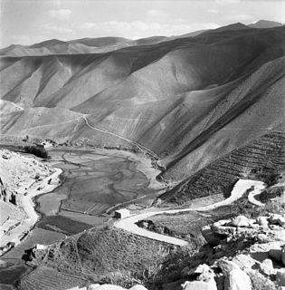
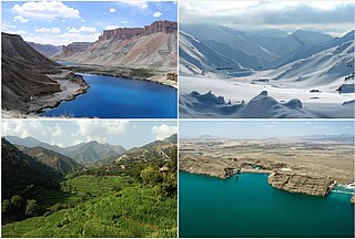
Bamyan Province is one of the thirty-four provinces of Afghanistan, located in the central highlands of the country. Its terrain is mountainous or semi-mountainous, at the western end of the Hindu Kush mountains concurrent with the Himalayas. The province is divided into eight districts, with the town of Bamyan serving as its capital. The province has a population of about 495,557 and borders Samangan to the north, Baghlan, Parwan and Wardak to the east, Ghazni and Daykundi to the south, and Ghor and Sar-e Pol to the west. It is the largest province in the Hazarajat region of Afghanistan, and is the cultural capital of the Hazara ethnic group that predominates in the area.

Bamyan also spelled Bamiyan or Bamian is the capital of Bamyan Province in central Afghanistan. With an altitude of about 2,550 m and a population of about 100,000, Bamyan is the largest town in the central Afghanistan region of Hazarajat, and lies approximately 240 kilometres north-west of Kabul, the national capital. It also refers to the surrounding valley. Many statues of Buddha are carved into the sides of cliffs facing Bamyan city. In 2008, Bamyan was found to be the home of the world's oldest oil paintings. The city of Bamyan has four districts and a total land area of 3,539 hectares. The total number of dwellings in this city are 4,435.

The Hajigak Pass is situated at a height of 3,700 metres (12,100 ft) above sea-level in the northern part of Maidan Wardak province, connecting it with Bamyan province to the northwest. It is one of the two main routes from Kabul to Bamyan in Hazarajat, leading across the Koh-i-Baba range.

Kahmard is a district of Bamyan Province in central Afghanistan. It is located at an altitude of 1,475 meters, with a population of 31,042. Kahmard is situated 140 km from Bamiyan city, in the north of the province, and is divided into five valleys.
Saighan District is part of Bamyan Province, Afghanistan. As of 2003 it has a population of 23,215. It was created in 2005 from part of Kahmard District, and until 2004 was part of Baghlan Province. Saighan town is the largest town and the administrative center. The district has an area of 1,741 km2 and contains sixty-two villages. Neighboring districts are Bamyan District to the south, Yakawlang District to the west, Kahmard District to the north, and Shibar District to the east.
Shahristan is a district in Daykundi Province, Afghanistan. Daykundi var established as a province in the distant north area in Uruzgan province in 2004,
Panjab district is in the central part of Bamiyan Province, Afghanistan. The capital is the town of Panjab. Panjab contains 5 valleys, the water running through the 5 valleys meet in the centre of the district. Its population is entirely Hazara people.
Shibar District is located in the western end of the Bamyan Province in Afghanistan. It is in a mountainous region. The main village Shibar is at 2,637 m altitude on the all-seasons secondary road from Bamyan to Kabul through the Shibar pass.
Waras (Varas) District is a mountainous district in the southern part of Bamyan Province, Afghanistan. Its population is 76,398 people (2011), who are entirely Hazara, according to AIMS data. The main village is Waras. It is situated at 2,794 m altitude.
Yakawlang District is located in the northwestern part of Bamyan Province. Its population is 76,897 (2011) predominantly from the Hazara ethnic group. The capital city Yakawlang formerly held 60,000 residents, and it was completely destroyed by Taliban forces in 2001. Massacres of civilians by the Taliban were reported by Human Rights groups.
There is a gravel surfaced airport near the city.
Shibar Pass in Afghanistan is situated at a height of 3,000 metres (9,800 ft) above sea-level, connecting Parwan Province with Bamyan Province. It is the longer of the two main routes from Kabul to Bamiyan in Hazarajat. The journey is approximately 6 and half hours long covering around 237 km (147 mi). It was originally designed and built by Ahmad Shah Shairzay and a German engineer between 1933 and 1938. It is noted to be an important mountain pass of the country.
Bamyan is a district of Bamyan Province in Afghanistan. In 2003, the population was put at 70,028, of which the majority group is Hazara while the Tajik is a minority group. New Zealand peace keepers operate in the district as well as most of Bamyan Province.

Daizangi also spelled as Dai Zangi,, is one of the major tribe of the Hazaras of Hazarajat in central Afghanistan. They inhabit the Bamyan, Yakawlang, Panjab and Waras districts of Bamyan Province, the Shahristan in Daikundi Province, Lal Wa Sarjangal District in Ghor Province and the Gizab District in Uruzgan Province. They are said to be the largest tribe of the Hazaras. The 19th-century Hazara Mir Elkhani, Mir Naser Beg, Mir (Chieftain) Mir Azeem Beg was the mir of the Daizangi who led the final battle of the Hazaras against Abdur Rahman Khan in the battle of Urozgan. He was exiled to Bokhara in present day Uzbekistan, where he wrote his memoirs "Yad e Guzishta", Memories of the past. Most Notable person from the Daizangi tribe is General Khudadad Khan.Their subtribes include the Bubali, Gedi, Kamyaba, Kut-daghi, Khushamadi, Kirigu, Miramur, Qaraqul Daghi, Sag Deh, Sag Jui, Sag-Pae, Sehpai, Takana, Takash, Urarus, and Yangur.
Yakawlang was a city of 65,000 people in Yakawlang District, Bamyan Province, Afghanistan. It is the capital of Yakawlang District with an altitude of 2714 m. It was significantly destroyed by military forces in 2000–2001.
Tourism in Afghanistan, developed with government help in the early 1970s, had revived to approximately 20,000 visitors annually by 2016 despite decades of war. Prior to the Taliban takeover in August 2021, Afghan embassies issued between 15,000 and 20,000 tourist visas annually. A valid passport with visa is required for entrance into Afghanistan. In 1999, the United Nations estimated the daily cost of staying in Kabul at $70 USD.
The Kunduz River is a tributary of the Amu Darya in northern Afghanistan. It rises in Bamyan Province in the Hindu Kush, and in its upper reaches is also known as the Bamyan River or the Surkhab River. After passing through Kunduz Province, the Kunduz River merges into the Amu Darya.
The Enlightenment Movement is a grassroots civil disobedience movement of Hazaras created in 2016 in Afghanistan in response to the Afghan government's change in routing plans for proposed international electricity networking, which was perceived as continuing historical anti-Hazara discrimination. The group organised major protests in Afghanistan and internationally during 2016 and 2017, protesting against discrimination. The group's youthful leadership challenged traditional Hazara leaders for representativity of the community.
