
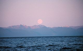
Port Alexander is a city at the southeastern corner of Baranof Island in Prince of Wales-Hyder Census Area, Alaska, United States. At the 2010 census the population was 52, down from 81 in 2000.

This is a list of the extreme points of North America: the points that are highest and lowest, and farther north, south, east or west than any other location on the continent. Some of these points are debatable, given the varying definitions of North America.
Chatham Strait, or Shee ya xhaak in the Tlingit language, is a narrow passage of the Alexander Archipelago in the southeastern region of the U.S. state of Alaska. It separates Chichagof Island and Baranof Island to its west from Admiralty Island and Kuiu Island on its east.

Peril Strait or Shee Káx’ is a strait in the Alexander Archipelago in southeastern Alaska. It is between Chichagof Island to its north and Baranof Island and Catherine Island to its south. The strait is 80 km (50 mi) long and reaches from Salisbury Sound on the west to the Chatham Strait on the east. It is entirely within the limits of the City and Borough of Sitka.
This is a list of the extreme points of The Americas, the points that are farther north, south, east or west than any other location on the continent. The continent's southernmost point is often said to be Cape Horn, which is the southernmost point of the Chilean islands. The Americas cross 134° of longitude east to west and 124° of latitude north to south.

Baranof Warm Springs is a small, primarily seasonally-occupied community located in the city and borough of Sitka, Alaska, on the eastern side of Baranof Island, from which it likely derives its name, in the Alexander Archipelago. It is occasionally referred to simply as Baranof. Baranof Warm Springs is located at 57°05′22″N134°49′59″W.

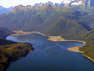
Baranof Lake is a glacially-fed, horseshoe-shaped lake on the eastern side of Baranof Island, in Alaska. Baranof Lake borders the community of Baranof Warm Springs and also has a Forest Service cabin on the northwestern end of the lake. Baranof River flows into the lake's western end and exits on the eastern end in rapids and a waterfall.
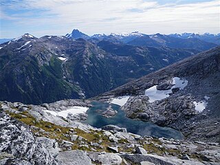
Camp Lake is a small snow-melt and rain-fed lake that feeds into the Blue Lake watershed on Baranof Island in the Alexander Archipelago in the Alaskan Panhandle. Camp Lake sits between Bear Mountain and Mount Bassie and atop a small headwall on the Medvejie Lake valley, although the lake drains into the Blue Lake watershed. Departing from the Medvejie Hatchery, the trail to Camp Lake spans approximately 3.33 miles (5.4 km) but requires considerable effort due to the difficult terrain and, in certain sections, dense vegetation.

The Teslin River is a river in southern Yukon Territory and northwestern British Columbia, Canada, that flows 632 kilometres (393 mi) from its source south of Teslin Lake to its confluence with the Yukon River.
The Ugashik Lakes are two adjacent lakes along the Ugashik River on the Alaska Peninsula in the U.S. state of Alaska.
Warm Springs Bay is a 2.4 mile-long bay located just outside the small community of Baranof Warm Springs on Baranof Island in the Alexander Archipelago, Alaska. Warm Springs Bay receives the outflow of Baranof Lake and Baranof River. Warm Springs Bay is located at 57°04′49″N134°48′12″W.
Mount Furuhelm is a 3,620 foot peak located on Baranof Island just east and adjacent to Peak 5390 in Alaska. It is located at 57°03′00″N134°55′47″W.
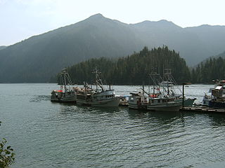
Silver Bay, or Gaǥeit', in the Tlingit language, is a deep water fjord located southeast of Sitka, Alaska, United States, that indents Baranof Island. It was named through a United States Coast and Geodetic Survey translation of Bukhta Serebryanikova, a name published first by Captain Tebenkov of the Imperial Russian Navy in 1852.
Partofshikof Island is an island in the Alexander Archipelago of southeastern Alaska, United States. It is part of the City and Borough of Sitka, and lies between the northern part of Kruzof Island and the northwestern part of Baranof Island. It is separated from Kruzof Island by Sukoi Inlet, and separated from Baranof Island by Neva Strait. Partofshikof Island has a land area of 34.177 km2 and no resident population.
Catherine Island is an island in the Alexander Archipelago of southeastern Alaska, United States. It is part of the City and Borough of Sitka and lies just off the northeast corner of Baranof Island, separated from it by Portage Arm. The U.S. Forest Service named Catherine Island in 1935 after Catherine I of Russia. Catherine Island has a land area of 86.936 km2 and no resident population.
The ABC Islands is the colloquial name for the Alaskan islands of Admiralty, Baranof, and Chichagof in the northern part of the Alexander Archipelago, which are all part of the Tongass National Forest. The islands are known for their wilderness and wildlife, including a dense brown bear population.

Baranof Island is an island in the northern Alexander Archipelago in the Alaska Panhandle, in Alaska. The name "Baranof" was given to the island in 1805 by Imperial Russian Navy captain U. F. Lisianski in honor of Alexander Andreyevich Baranov. It was called Sheet’-ká X'áat'l by the native Tlingit people. It is the smallest of the ABC islands of Alaska. The indigenous group native to the island, the Tlingit, named the island Shee Atika. Baranof island is home to a diverse ecosystem, which made it a prime location for the fur trading company, the Russian American Company. The Russian occupation of Baranof Island impacted not only the indigenous population and the ecology of the island, but also led to the United States' current ownership over the land.
The South Baranof Wilderness is a federally designated wilderness area within the Tongass National Forest, located on Baranof Island, Alaska. Covering 319,568 acres south of Sitka, the South Baranof protects glacier-carved fjords, hanging valleys, old-growth temperate rainforests and sheer granite mountains.
Cannon Island is a small island in Sitka, Alaska, United States. It is connected to Baranof Island and Sitka by a gravel causeway, Cannon Island Drive. The island was named "Pushki" by explorer Ivan Vasilyev in 1809.

