
Lake Baikal is a large rift lake in Russia. It is situated in southern Siberia, between the federal subjects of Irkutsk Oblast to the northwest and the Republic of Buryatia to the southeast.

The Laptev Sea is a marginal sea of the Arctic Ocean. It is located between the northern coast of Siberia, the Taimyr Peninsula, Severnaya Zemlya and the New Siberian Islands. Its northern boundary passes from the Arctic Cape to a point with co-ordinates of 79°N and 139°E, and ends at the Anisiy Cape. The Kara Sea lies to the west, the East Siberian Sea to the east.

Bruny Island is a 362-square-kilometre (140 sq mi) island located off the southeastern coast of Tasmania, Australia. The island is separated from the Tasmanian mainland by the D'Entrecasteaux Channel, and its east coast lies within the Tasman Sea. Located to the island's northeast Storm Bay, is the river mouth to the Derwent River estuary, and serves as the main port of Hobart, Tasmania's capital city. Both the island and the channel are named after French explorer, Antoine Bruni d'Entrecasteaux. Its traditional Aboriginal name is lunawanna-allonah, which survives as the name of two island settlements, Alonnah and Lunawanna.

Barguzinsky Nature Reserve is the oldest of zapovedniks, established in 1916 for the protection of the Barguzin sable. It is located in Buryatia (Russia) on the west slope of the Barguzinsky Range, including the northeast shores of the Lake Baikal and a part of the lake itself. The area of the reserve is 2,482 km2 (958 sq mi), covering several types of boreal ecosystems, from bogs and taiga coniferous forests to subalpine meadows and mountain tundras. The landscape is postglacial, featuring rugged highlands, long river valleys and outwash, alluvial and lacustrine plains.

The Barguzin is a river in Buryatia, Russia, 480 km (300 mi) long, flowing into the Barguzin Bay of Lake Baikal, the largest and deepest bay of Baikal. Barguzin is the third inflow of Baikal, after the rivers Selenga and Upper Angara. Its watershed area is 21,100 km2 (8,100 sq mi). It is navigable for 204 km (127 mi) upwards from its estuary. Its main tributaries are the Gagra, Argada and Ina from the left, and the Ulyun from the right. In 1648, Ivan Galkin founded an ostrog on the Barguzin.
St. George's Bay - informally referred to as Bay St. George due to its French translation Baie St-George - is a large bay in the province of Newfoundland and Labrador, Canada. It is located on the west coast of the island of Newfoundland and comprises a sub-basin of the Gulf of St. Lawrence. The estimated population of the entire bay is 16,000, based on the demographic data of each community.
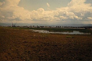
Ust-Barguzin is an urban locality in Barguzinsky District of the Republic of Buryatia, Russia, located on the shore of Lake Baikal at the mouth of the Barguzin River and 270 kilometers (170 mi) northeast of Ulan-Ude, the capital of the republic. As of the 2010 Census, its population was 7,173.
The Bonavista Peninsula is a large peninsula on the east coast of the island of Newfoundland in the Canadian province of Newfoundland and Labrador. It consists of 50 incorporated towns/unincorporated communities which have a population of 12,176 as of the 2016 Canadian Census. Bonavista is the largest population centre on the peninsula.
Mount Bird is a 1,765 metres (5,791 ft) high shield volcano standing about 7 nautical miles south of Cape Bird, the northern extremity of Ross Island. It was mapped by the British National Antarctic Expedition, 1901–04, under Robert Falcon Scott, and apparently named by them after Cape Bird.
Severo-Baykalsky District is an administrative and municipal district (raion), one of the twenty-one in the Republic of Buryatia, Russia. It is located in the northeast of the republic. The area of the district is 54,000 square kilometers (21,000 sq mi). Its administrative center is the urban locality of Nizhneangarsk. As of the 2010 Census, the total population of the district was 14,035, with the population of Nizhneangarsk accounting for 35.8% of that number.

Kiillinnguyaq, formerly the Kent Peninsula, is a large Arctic peninsula, almost totally surrounded by water, in the Kitikmeot Region of Nunavut. Were it not for a 8.0 km (5 mi) isthmus at the southeast corner it would be a long island parallel to the coast. From the isthmus it extends 169 km (105 mi) westward into the Coronation Gulf. To the south, Melville Sound separates it from the mainland. To the north is Dease Strait and then Victoria Island. To the west is Coronation Gulf and to the east, Queen Maud Gulf. Cape Flinders marks the western tip of the peninsula, Cape Franklin is at the northwestern point, and Hiiqtinniq, formerly Cape Alexander marks the northeastern point.
Kurbat Afanasyevich Ivanov was a Cossack explorer of Siberia. He was the first Russian to encounter Lake Baikal, and to create the first map of the Russian Far East. He also is credited with creation of the early map of Chukotka and Bering Strait, which was the first to show the yet undiscovered Wrangel Island, both Diomede Islands and Alaska.
Nuussuaq Peninsula is a mainland peninsula in northwestern Greenland, located at the northern end of Upernavik Archipelago, approximately 70 km (43 mi) to the south of Melville Bay. It is much smaller than its namesake in western Greenland.
Zaybaykalsky National Park covers the middle section of the eastern shore of Lake Baikal, the west slope of the Barguzin mountains to the east, the Ushkany Islands, and the only large peninsula on the lake, Svyatoy Nos. Of the 2,690 km2 (1,040 sq mi) of the park, 38.8 km2 are protected water areas of the lake itself.
The Transbaikal conifer forests ecoregion covers a 1,000 km by 1,000 km region of mountainous southern taiga stretching east and south from the shores of Lake Baikal in the Southern Siberia region of Russia, and including part of northern Mongolia. Historically, the area has been called "Dauria", or Transbaikal. It is in the Palearctic realm, and mostly in the boreal forests/taiga biome with a subarctic, humid climate. It covers 200,465 km2 (77,400 sq mi).

Baikalia is a vague geographical term referring to the region around Lake Baikal. It is less common than the concept of Transbaikalia, the area to the east of Lake Baikal. The term Baikalia is loosely defined and has no official definition.

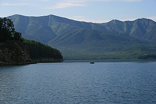
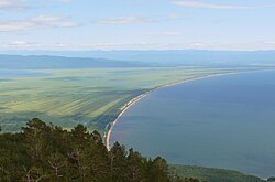
Svyatoy Nos is a large peninsula on the eastern edge of Lake Baikal, Eastern Siberia, in the Barguzinsky District of the Republic of Buryatia. It is part of the Zabaykalsky (Trans-Baikal) National Park.

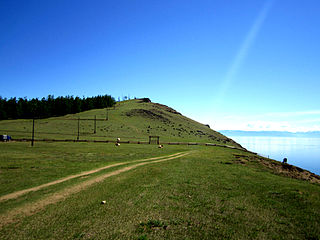
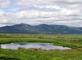
The Chivyrkuisky Isthmus is a broad land bridge that connects the island-like mountainous part of the Svyatoy Nos peninsula to the eastern shore of Lake Baikal. The isthmus and the "island" are part of the Zabaykalsky (Trans-Baikal) National Park of the Republic of Buryatia.

Sellyakh Bay is a bay in Ust-Yansky District, Sakha Republic (Yakutia), Russian Federation.
