
The Philippines is an archipelago that comprises 7,641 islands with a total land area of 300,000 square kilometers (115,831 sq mi). It is the world's fifth largest island country. The eleven largest islands contain 95% of the total land area. The largest of these islands is Luzon at about 105,000 square kilometers (40,541 sq mi). The next largest island is Mindanao at about 95,000 square kilometers (36,680 sq mi). The archipelago is around 800 kilometers (500 mi) from the Asian mainland and is located between Taiwan and Borneo.

Luzon is the largest and most populous island in the Philippines. Located in the northern portion of the Philippines archipelago, it is the economic and political center of the nation, being home to the country's capital city, Manila, as well as Quezon City, the country's most populous city. With a population of 64 million as of 2021, it contains 52.5% of the country's total population and is the 4th most populous island in the world. It is the 15th largest island in the world by land area.

The South China Sea is a marginal sea of the Western Pacific Ocean. It is bounded in the north by the shores of South China, in the west by the Indochinese Peninsula, in the east by the islands of Taiwan and northwestern Philippines, and in the south by the Indonesian islands of Borneo, eastern Sumatra and the Bangka Belitung Islands, encompassing an area of around 3,500,000 km2 (1,400,000 sq mi). It communicates with the East China Sea via the Taiwan Strait, the Philippine Sea via the Luzon Strait, the Sulu Sea via the straits around Palawan, and the Java Sea via the Karimata and Bangka Straits. The Gulf of Thailand and the Gulf of Tonkin are also part of South China Sea.
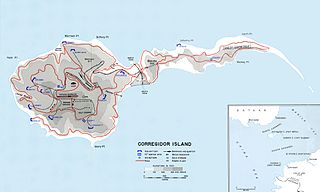
Corregidor is an island located at the entrance of Manila Bay in the southwestern part of Luzon in the Philippines, and is considered part of the Province of Cavite. Due to this location, Corregidor has historically been fortified with coastal artillery batteries to defend the entrance of Manila Bay and Manila itself from attacks by enemy warships. Located 48 kilometres (30 mi) inland, Manila is the nation's largest city and has been the most important seaport in the Philippines for centuries, from the colonial rule of Spain, Japan, and the United States, up through the establishment of the Third Philippine Republic in 1946.

The Babuyan Islands, also known as the Babuyan Group of Islands, is an archipelago in the Philippines, located in the Luzon Strait north of the main island of Luzon and south of Taiwan via Bashi Channel to Luzon Strait. The archipelago consists of five major islands and their surrounding smaller islands. These main islands are, counterclockwise starting from northeast, Babuyan, Calayan, Dalupiri, Fuga, and Camiguin. The Babuyan Islands are separated from Luzon by the Babuyan Channel, and from the province of Batanes to the north by the Balintang Channel.

Batanes, officially the Province of Batanes, is an archipelagic province in the Philippines, administratively part of the Cagayan Valley region. It is the northernmost province in the Philippines, and the smallest, both in population and land area. The capital is Basco, located on the island of Batan.

Calayan, officially the Municipality of Calayan, is a 3rd class municipality in the province of Cagayan, Philippines. According to the 2020 census, it has a population of 17,410 people.
Calayan Island is located about 24 miles west-southwest of Babuyan Island off the north coast of the Philippines and belongs to the Babuyan Islands group in the Luzon Strait. The island is hemmed between Aparri and Batanes islands and it is larger than the Fuga Island, which is 25 miles (40 km) away. Calayan is home to the Calayan rail, a flightless bird identified as a separate species in 2004 and endemic to Calayan Island. The island is part of the Municipality of Calayan.
Didicas Volcano is an active volcanic island in the province of Cagayan in northern Philippines. The island, which was a submarine volcano and re-emerged from the sea in 1952, is 22 kilometres (14 mi) NE of Camiguin Island, one of the Babuyan Islands in Luzon Strait. Before 1952, the volcano first breached the ocean surface in 1857.

Pamalican Island, also known as Pamalikan, is a small and sandy island of the Cuyo Islands in the Sulu Sea, between Palawan and Panay, in the north part of the Palawan Province of the Philippines. The island is set in the middle of a 7-square-kilometre (2.7 sq mi) coral reef. It has a length of 2.5 kilometres (1.6 mi), and measures only 500 metres (1,600 ft) at its widest point. Pamalican can be found 7 miles southwest of Quiniluban island and 3 miles northeast of Manamoc island.

Kalayaan, officially the Municipality of Kalayaan, is a 5th class municipality in the South China Sea under the jurisdiction of the province of Palawan, Philippines. According to the 2020 census, it has a population of 193 people making it the least populated town in the Philippines.

Fuga Island is an island and barangay located north of Luzon and is part of the Babuyan Islands, which is the second-northernmost island group of the Philippines. Barangay Fuga Island is one of the 42 barangays under the jurisdiction of the municipality of Aparri in the province of Cagayan.
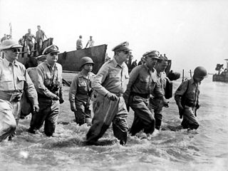
The Philippines campaign, Battle of the Philippines, Second Philippines campaign, or the Liberation of the Philippines, codenamed Operation Musketeer I, II, and III, was the American, Mexican, Australian and Filipino campaign to defeat and expel the Imperial Japanese forces occupying the Philippines during World War II.
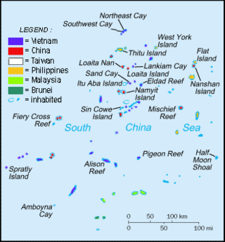
Philippines and the Spratly Islands – this article discusses the policies, activities and history of the Republic of the Philippines in the Spratly Islands from the Philippine perspective. Non-Philippine viewpoints regarding Philippine occupation of several islands are currently not included in this article.

Tan Yu was a Chinese-Filipino philanthropist and businessman who founded the Asiaworld Internationale Group and established the KTTI Foundation, which provided scholarships to and supported the education of thousands of young students. In 1997, Forbes listed Tan Yu as the 7th wealthiest person in the world, estimating his net worth to be about $7 billion. He was placed amongst the top 10 in the world on the Forbes List of World Billionaires 1997, making him the wealthiest man in the Philippines.

The Quiniluban Group is a group of islands in Palawan Province of the Philippines situated between the islands of Palawan and Panay in the Sulu Sea. The group is the northernmost in the Cuyo Archipelago, consisting of several islands and rocks. The easternmost of which is a circular group of islands surrounded by reef about 6 nautical miles in diameter. The largest of the circular group is Quiniluban Island. The island group also includes the upscale resort island of Pamican located about 5.6 nautical miles southwest of the circular group, and Manamoc Island located 3.0 nautical miles further southwest of Pamilacan.
Balintang Islands are a small group of rocky islands in the middle of Balintang Channel, in Luzon Strait, northern Philippines. The islands are almost equidistant to both Babuyan Island, Cagayan, which lies about 29 miles (47 km) to the southwest, and Sabtang Island, Batanes, located 28 miles (45 km) to the northwest. The group is composed of seven small, sharp-peaked islets and rocks visible about 24 miles (39 km) in clear weather. Taiwan will be also directly to the north of Luzon Island in the Philippines via Luzon Strait to Bashi Channel.
Bulubadiangan Island is a privately owned island in northeastern Iloilo, Philippines. It is part of barangay Polopińa, Concepcion. The Sandbar Island Beach Resort on Bulubadiangan is moderately known within the Philippines.
Dalupiri Island is an island in the Babuyan Islands in Luzon Strait north of Luzon Island in the Philippines. The whole island makes up the barangay of Dalupiri, which is part of the municipality of Calayan in Cagayan province, which had 621 inhabitants in 2020, up from 611 in 2010.
Ro-46 was an Imperial Japanese Navy Kaichū type submarine of the K6 sub-class. Completed and commissioned in February 1944, she served in World War II, including operations related to the Marianas campaign, the Philippines campaign, and the Battle of Okinawa. She disappeared in April 1945 during her fifth war patrol.

