Bark River (Michigan)

Last updated
Bark River
Country United States
State Michigan
Region Upper Peninsula
Physical characteristics
Main sourceoutflow of Second Lake
45°44′19″N87°19′09″W / 45.7386°N 87.3192°W / 45.7386; -87.3192
River mouth Green Bay
45°34′21″N87°14′34″W / 45.5725°N 87.24278°W / 45.5725; -87.24278 Coordinates: 45°34′21″N87°14′34″W / 45.5725°N 87.24278°W / 45.5725; -87.24278
Length24 mi (39 km)

Bark River is a 23.7-mile-long (38.1 km) [1] river on the Upper Peninsula of the U.S. state of Michigan. The river flows into Green Bay on Lake Michigan in Ford River Township about 15 miles (24 km) southwest of Escanaba at 45°34′22″N87°14′34″W / 45.57278°N 87.24278°W / 45.57278; -87.24278 .

River Natural flowing watercourse

A river is a natural flowing watercourse, usually freshwater, flowing towards an ocean, sea, lake or another river. In some cases a river flows into the ground and becomes dry at the end of its course without reaching another body of water. Small rivers can be referred to using names such as stream, creek, brook, rivulet, and rill. There are no official definitions for the generic term river as applied to geographic features, although in some countries or communities a stream is defined by its size. Many names for small rivers are specific to geographic location; examples are "run" in some parts of the United States, "burn" in Scotland and northeast England, and "beck" in northern England. Sometimes a river is defined as being larger than a creek, but not always: the language is vague.

Upper Peninsula of Michigan Northern major peninsula of the U.S. state of Michigan

The Upper Peninsula (UP), also known as Upper Michigan, is the northern of the two major peninsulas that make up the U.S. state of Michigan. The peninsula is bounded on the north by Lake Superior, on the east by the St. Marys River, and on the southeast by Lake Michigan and Lake Huron. Geographically, the Upper Peninsula has a land boundary with Wisconsin, and over-water boundaries with Minnesota and Ontario (Canada). Upper Peninsula counties also include nearby islands such as Grand, Drummond, Mackinac, and Bois Blanc, and more distant Isle Royale.

U.S. state constituent political entity of the United States

In the United States, a state is a constituent political entity, of which there are currently 50. Bound together in a political union, each state holds governmental jurisdiction over a separate and defined geographic territory and shares its sovereignty with the federal government. Due to this shared sovereignty, Americans are citizens both of the federal republic and of the state in which they reside. State citizenship and residency are flexible, and no government approval is required to move between states, except for persons restricted by certain types of court orders. Four states use the term commonwealth rather than state in their full official names.

The Bark River rises from the outflow of Second Lake (which is fed by Pine Creek and the outflow of First Lake) on the boundary between Delta County and Menominee County at 45°44′19″N87°19′09″W / 45.73861°N 87.31917°W / 45.73861; -87.31917 . The North Branch Bark River rises in a marshy area just east of Schaffer, Michigan in Bark River Township and joins the main course at 45°43′28″N87°16′23″W / 45.72444°N 87.27306°W / 45.72444; -87.27306 .

Delta County, Michigan County in the United States

Delta County is a county in the Upper peninsula in the U.S. state of Michigan. As of the 2010 United States Census, the population was 37,069. The county seat is Escanaba. The county was surveyed in 1843 and organized in 1861. Its name originates from the Greek letter "delta", which refers to the triangular shape of the original county which included segments of Menominee, Dickinson, Iron, and Marquette counties.

Menominee County, Michigan County in the United States

Menominee County is a county located in the Upper Peninsula in the U.S. state of Michigan. As of the 2010 United States Census, the population was 24,029. The county seat is Menominee. The county's name comes from an American Indian word meaning "wild rice eater" used to describe a tribe. The county was created in 1861 from area partitioned out of Delta County, under the name of Bleeker. When county government was organized in 1863, the name was changed to Menominee.

Bark River Township, Michigan Civil township in Michigan, United States

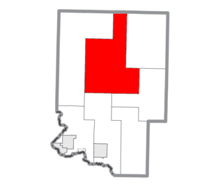
Bark River Township is a civil township of Delta County in the U.S. state of Michigan. As of the 2010 census, the township population was 1,578, down from 1,650 at the 2000 census. The township takes its name from the Bark River.

The Bark River was named by some of the first railroad engineers in the area who saw a great quantity of bark floating on the water. [2]

Bark (botany) external parenchymal tissue, located just below the epidermis in the primary structure of the stem

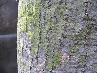
Bark is the outermost layers of stems and roots of woody plants. Plants with bark include trees, woody vines, and shrubs. Bark refers to all the tissues outside the vascular cambium and is a nontechnical term. It overlays the wood and consists of the inner bark and the outer bark. The inner bark, which in older stems is living tissue, includes the innermost area of the periderm. The outer bark in older stems includes the dead tissue on the surface of the stems, along with parts of the innermost periderm and all the tissues on the outer side of the periderm. The outer bark on trees which lies external to the last formed periderm is also called the rhytidome.

Related Research Articles

Limestone Township, Michigan Civil township in Michigan, United States

Limestone Township is a civil township of Alger County in the U.S. state of Michigan. The population was 438 at the 2010 census.

Heath Township, Michigan Township in Michigan, United States

Heath Township is a civil township of Allegan County in the U.S. state of Michigan. As of the 2010 census, the township population was 3,317.

Baldwin Township, Delta County, Michigan Civil township in Michigan, United States

Baldwin Township is a civil township of Delta County in the U.S. state of Michigan. As of the 2010 census, the township population was 759, slightly up from 748 at the 2000 census.

Breen Township, Michigan Civil township in Michigan, United States

Breen Township is a civil township of Dickinson County in the U.S. state of Michigan. As of the 2010 census, the township population was 499, slightly up from 479 at the 2000 census.

Felch Township, Michigan Civil township in Michigan, United States

Felch Township is a civil township of Dickinson County in the U.S. state of Michigan, named in honor of Alpheus Felch. The population was 752 at the 2010 census, slightly up from 726 at the 2000 census.

Norway Township, Michigan Civil township in Michigan, United States

Norway Township is a civil township of Dickinson County in the U.S. state of Michigan. The population was 1,489 at the 2010 census, down from 1,639 at the 2000 census.

Quinnesec, Michigan Census-designated place & Unincorporated community in Michigan, United States

Quinnesec is an unincorporated community in Dickinson County in the U.S. state of Michigan. It is a census-designated place (CDP) for statistical purposes and has no legally recognized status as a municipality. The population was 1,191 at the 2010 census. It is part of the Iron Mountain, MI–WI Micropolitan Statistical Area.

Bark River, Michigan Unincorporated community in Michigan, United States

Bark River is an unincorporated community located in Delta County in the U.S. state of Michigan. It is located in Bark River Township near the Bark River, from which it is named. It is situated on U.S. Highway 2 and U.S. Highway 41 about 13 miles west of Escanaba and just east of the Hannahville Indian Reservation.

Watersmeet, Michigan Census-designated place in Michigan, United States

Watersmeet is an unincorporated community and census-designated place (CDP) in Watersmeet Township, Gogebic County, Michigan, in the United States. As of the 2010 census, the CDP had a population of 428, out of a total population in the township of 1,417. The community was platted in 1884, designated as a station of the Chicago, St. Paul, Minneapolis & Omaha Railways.

The Days River is a 30.1-mile-long (48.4 km) river on the Upper Peninsula of the U.S. state of Michigan.

Coldwater River is a 29.5-mile-long (47.5 km) stream in the U.S. state of Michigan. Located in Branch County, the river rises in Ovid Township at 41°50′14″N84°59′13″W as the outflow of Coldwater Lake. Flowing north and west, it is joined by the outflow from the Lake of the Woods and continues north for several miles. West of the city of Coldwater, it flows through a series of lakes: South Lake, Messenger Lake, Cemetery Lake, North Lake, Randall Lake, Morrison Lake, Craig Lake, and Hodunk Pond. It then continues to the northwest and empties into the St. Joseph River in the village of Union City at 42°03′58″N85°07′48″W.

Coldwater River (Western Michigan)

The Coldwater River is a 19.4-mile-long (31.2 km) stream in the U.S. state of Michigan. Located in western Michigan, the river is a part of the Grand River drainage basin.

Coldwater River is a 13.1-mile-long (21.1 km) stream in the U.S. state of Michigan. Located in Isabella County, the river rises as the outflow of Littlefield Lake in western Gilmore Township. The river flows mostly south and empties into the Chippewa River at 43°37′22.231″N84°57′38.243″W on the western boundary of Deerfield Township, about two miles east of Lake Isabella.

Siloam Township, Surry County, North Carolina township in Surry County, North Carolina

Siloam Township is one of fifteen townships in Surry County, North Carolina. The township had a population of 1,071 according to the 2000 census, making it the smallest township in Surry County by population.

Cedar Creek may refer to several small streams in the U.S. state of Michigan:

The Mitchigan River is a 14.9-mile-long (24.0 km) stream in the Upper Peninsula of the U.S. state of Michigan. It flows into the Fence River at 46°17′27″N88°09′58″W in northeast Iron County in Mansfield Township. The Fence River is a tributary of the Michigamme River, which is itself a tributary the Menominee River, flowing to Lake Michigan. The Mitchigan River has its source in the southeast corner of Baraga County at 46°24′58″N88°08′05″W. It flows mostly southward along the boundary between Iron and Marquette counties, crossing briefly into western Marquette County.

Prairie River (Michigan) river in the United States of America

The Prairie River is a small river that flows 54 miles (87 km) through Branch and St. Joseph counties in Michigan. The river rises at 41°48′20″N85°00′54″W in northern Kinderhook Township in Branch County, and flows west-northwest into the St. Joseph River at 41°54′45″N85°38′21″W just south of the city of Three Rivers, Michigan.

The Little Pigeon River is a 10.2-mile-long (16.4 km) stream in Otsego and Cheboygan counties in the U.S. state of Michigan.

The Maple River, which flows into Burt Lake, is a major river in the northern tip of the Lower Peninsula of the U.S. state of Michigan. The river drains sections of Cheboygan County and Emmet County, and provides an outflow for the 3,395-acre (1,374 ha) Douglas Lake.

References

  1. U.S. Geological Survey. National Hydrography Dataset high-resolution flowline data. The National Map Archived 2012-04-05 at WebCite , accessed December 19, 2011
  2. Chicago and North Western Railway Company (1908). A History of the Origin of the Place Names Connected with the Chicago & North Western and Chicago, St. Paul, Minneapolis & Omaha Railways. p. 41.