
Kenosha County is located in the southeastern corner of the U.S. state of Wisconsin. The population was 169,151 as of the 2020 census, making it the eighth most populous county in Wisconsin. The county shares the same name as the city of Kenosha, the fourth largest city in Wisconsin. Kenosha County is part of the Chicago metropolitan area, the fourth most-populous metropolitan area in North America. Kenosha County is situated on the southwestern shore of Lake Michigan.

Pleasant Prairie is a village in the U.S. state of Wisconsin. Located in Kenosha County along the southwestern shoreline of Lake Michigan, Pleasant Prairie was home to 21,250 people at the 2020 census. The village is positioned directly south of the city of Kenosha and directly north of the Illinois border. Although located just 37 miles south of Milwaukee, it is part of the United States Census Bureau's Chicago combined statistical area (CSA) and metropolitan statistical area despite being 57 miles north of that city. Among its notable features are the RecPlex and Chiwaukee Prairie.

Somers is a village in Kenosha County, Wisconsin, United States. The population was 8,402 at the 2020 census. Somers has a post office with ZIP code 53171. The former unincorporated communities of Berryville, Central Park, and Kellogg's Corners are located in the village.
Red Clay Creek is a 12.7-mile-long (20.4 km) tributary of White Clay Creek, running through southeastern Pennsylvania and northern Delaware in the United States. As of 2000, portions of the creek are under wildlife habitat protection.

Conococheague Creek, a tributary of the Potomac River, is a free-flowing stream that originates in Pennsylvania and empties into the Potomac River near Williamsport, Maryland. It is 80 miles (129 km) in length, with 57 miles (92 km) in Pennsylvania and 23 miles (37 km) in Maryland. The watershed of Conococheague Creek has an area of approximately 566 square miles (1,470 km2), out of which only 65 square miles (170 km2) are in Maryland.
Tinker's Creek, in Cuyahoga, Summit and Portage counties, is the largest tributary of the Cuyahoga River, providing about a third of its flow into Lake Erie.

Pine River may refer to any of the following rivers in the U.S. state of Michigan:

Adams Township is one of thirteen townships in Parke County, Indiana, United States. As of the 2010 census, its population was 5,825 and it contained 2,062 housing units.

Poquessing Creek is a 10.3-mile-long (16.6 km) creek, a right tributary of the Delaware River, that forms the boundary between Philadelphia and Bensalem Township, which borders it to the northeast along the Delaware. It has defined this boundary between Bucks and Philadelphia counties since 1682.

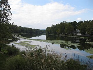
The Root River is a 43.7-mile-long (70.3 km) river that flows to Lake Michigan at the city of Racine in southeastern Wisconsin in the United States. Racine and Racine County are named for the river, as racine is the French word for root.

Split Rock Creek State Park is a state park of Minnesota, USA, located in Ihlen, or just south of Pipestone.

Yellow Breeches Creek, also known as Callapatscink Creek, Callapatschink Creek or Shawnee Creek is a 56.1-mile-long (90.3 km) tributary of the Susquehanna River in central Pennsylvania, USA. There is no agreed upon explanation for the name Yellow Breeches Creek, which is found in land warrants as early as 1736.
Conodoguinet Creek is a 104-mile-long (167 km) tributary of the Susquehanna River in South central Pennsylvania in the United States. The name is Native American, and means "A Long Way with Many Bends".
Laurel Hill Creek is a 39.9-mile-long (64.2 km) tributary of the Casselman River that is located in Somerset County, Pennsylvania, in the United States. It is part of the Youghiogheny River watershed, flowing to the Monongahela River, the Ohio River, and ultimately the Mississippi River.
Codorus Creek is a 42.4-mile-long (68.2 km) tributary of the Susquehanna River in York County, Pennsylvania in the United States.

Fishing Creek is a 42.8-mile-long (68.9 km) tributary of Bald Eagle Creek in Clinton County, Pennsylvania, in the United States.
Muddy Creek is a tributary of the Susquehanna River in York County, Pennsylvania, in the United States.

Sugar Creek Township is one of thirteen townships in Parke County, Indiana, United States. As of the 2010 census, its population was 322 and it contained 154 housing units. The township includes the north half of Turkey Run State Park.
Poso Creek or Posey Creek is an 87.9-mile (141.5 km) intermittent stream in Kern County, California.
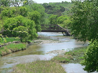
Ponca Creek is a stream that flows from southern South Dakota and into northern Nebraska. It is 139 miles (224 km) long. Its source is about 4 miles (6.4 km) west of U.S. 183, near Colome. It flows into the Missouri River 6 miles (9.7 km) northwest of Niobrara. Ponca Creek starts out going east, then takes a southeast direction. It flows like that until around Bristow, Nebraska where it turns east again until it flows into the Missouri River. The entire Ponca Creek watershed drains 520,000 acres (2,100 km2). The watershed stretches from central Tripp County to central Gregory County.

