
Barney's River Station in Nova Scotia
Barney's River Station is a community in the Canadian province of Nova Scotia, located in Pictou County.
Barney's River Station is a community in the Canadian province of Nova Scotia, located in Pictou County.
Highway 104 in Nova Scotia, Canada, runs from Fort Lawrence at the New Brunswick border near Amherst to River Tillard near St. Peter's. Except for the portion on Cape Breton Island between Port Hawkesbury and St. Peter's, it forms the main route of the Trans-Canada Highway across the province.
Durham is a community in the Canadian province of Nova Scotia, located in Pictou County on Nova Scotia Route 376 alongside the West River of Pictou. The centre of the village is about 10 km up-stream from the town of Pictou. The Durham Presbyterian Church is located near the bridge on the west side of the river, and the Durham Community Hall is on the east side of the river, adjacent to the cemetery.
Sutherland's River is a community in the Canadian province of Nova Scotia, located in Pictou County.
West River Station is a community in the Canadian province of Nova Scotia, located in Pictou County.
East River St. Marys is a small community in the Canadian province of Nova Scotia, located in Pictou County.
West River is a community in the Canadian province of Nova Scotia, located in Pictou County.
Lower Barney's River is a small community in the Canadian province of Nova Scotia, located in Pictou County. Lower Barney's River is named after being the lower part of the large river called "Barney's River".
Clydesdale is a community in the Canadian province of Nova Scotia, located in Antigonish County.
Sheepherders Junction is a community in the Canadian province of Nova Scotia, located in Colchester County in the Stewiacke Valley. It is located at the border between Colchester County and Pictou County, Nova Scotia at the intersection of Dryden Lake Road with Route 289. Nearby on Fall Brook, a tributary of the Stewiake River, is the 12 m Fall Brook Fall.
French River is a community in the Canadian province of Nova Scotia, located in Pictou County.
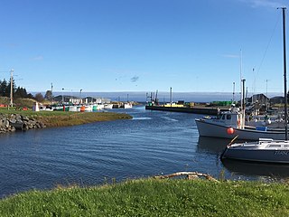
Toney River is a community in the Canadian province of Nova Scotia, located at the mouth of the Toney River in Pictou County. The river has a deep, narrow estuary which has been improved seaward of the Sunrise Trail bridge as a harbour including moorings for about a dozen fishing boats. The community is named after a Mi'kmaq chief who is reported to have signed the Halifax Treaties in 1761.
Caribou River is a community in the Canadian province of Nova Scotia, located in Pictou County.
Bridgeville is a community in the Canadian province of Nova Scotia, located in Pictou County. It is on Nova Scotia Route 348 and the East River of Pictou.
Ashdale is a small community in the Canadian province of Nova Scotia, located in Antigonish County. It is on Nova Scotia Trunk 7, approximately 13 km south of Antigonish, at an elevation around 100m. It was formerly known as Collegeville and an Environment Canada weather station in the community retains the name Collegeville. The Collegeville post office was opened on June 1, 1887 and closed February 29, 1932.
James River is a community in the Canadian province of Nova Scotia, located in Antigonish County. The Riverside International Speedway is located here.
Glengarry is a community in the Canadian province of Nova Scotia, located in Pictou County. It is at the headwaters of the Middle River and on the Cape Breton and Northern Nova Scotia Railway line to Truro. It is now a small farming community but once had a railway station, post office, watering tank for steam locomotives supplied by water from the Middle River, and a school.
There are various Black Lakes in Nova Scotia, Canada. They vary widely in size, depth and usability. Many counties, such as Cumberland, Halifax, Inverness, and Pictou Counties have more than one Black Lake so named, while other counties mentioned in this article have only one named Black Lake.
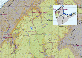
Eigg Mountain is high plateau, part of the highlands of Antigonish County, Nova Scotia, Canada.

A township in Nova Scotia, Canada, was an early form of land division and local administration during British colonial settlement in the 18th century. They were created as a means of populating the colony with people loyal to British rule. They were typically rural or wilderness areas of around 100,000 acres (400 km2) that would eventually include several villages or towns. Some townships, but not all, returned a member to the General Assembly of Nova Scotia; others were represented by the members from the county. Townships became obsolete by 1879 by which time towns and counties had become incorporated.
| | This Pictou County, Nova Scotia location article is a stub. You can help Wikipedia by expanding it. |