Related Research Articles
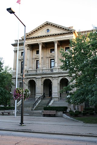
Lorain County is a county in the northeastern part of the U.S. state of Ohio As of the 2020 census, the population was 312,964. Its county seat is Elyria, and its largest city is Lorain. The county was physically established in 1822, becoming judicially independent in 1824. Lorain County is part of the Cleveland, OH Metropolitan Statistical Area. The county is home to Oberlin College.
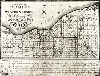
The Firelands, or Sufferers' Lands, tract was located at the western end of the Connecticut Western Reserve in what is now the U.S. state of Ohio. It was legislatively established in 1792, as the "Sufferers' Lands", and later became named "Fire Lands" because the resale of the land was intended as financial restitution for residents of the Connecticut towns of Danbury, Fairfield, Greenwich, Groton, New Haven, New London, Norwalk, and Ridgefield. Their homes had been burned in 1779 and 1781 by British forces during the American Revolutionary War. However, most of the settlement of the area did not occur until after the War of 1812. "Fire Lands" was later spelled as one word: "Firelands."

Little Beaver Creek is a wild and scenic area in Ohio. The Little Beaver Creek watershed is located primarily in Columbiana County in eastern Ohio, and in portions of Carroll County, Mahoning County, and western Pennsylvania, draining approximately 605 mi² (1,567 km²), of which 503 mi² (1,303 km²) are in Ohio. The watershed in total size covers an area of approximately 510 square miles, with about 80% of this being situated in Ohio. The great majority of land within the watershed is privately owned. Within the watershed are roughly 808 miles of linear streams.

The Vermilion River is a river in northern Ohio in the United States. It is 66.9 miles (107.7 km) long and is a tributary of Lake Erie, draining an area of 268 square miles (690 km2). The name alludes to the reddish clay that is the predominant local soil along its route. The river is commonly muddy after rains.

Little Muncy Creek is the major tributary of Muncy Creek in Lycoming and Sullivan Counties, Pennsylvania, United States. Via Muncy Creek and the West Branch Susquehanna River, it is part of the Susquehanna River drainage basin and waters from it flow ultimately into the Chesapeake Bay.

The Black River is a tributary of Lake Erie, about 12 mi (19 km) long, in northern Ohio in the United States. Via Lake Erie, the Niagara River and Lake Ontario, it is part of the watershed of the St. Lawrence River, which flows to the Atlantic Ocean. The Black drains an area of 470 mi² (1217 km²).

Lorain County Community College (LCCC) is a public community college in the city of Elyria in Lorain County, Ohio, with learning centers in Wellington, North Ridgeville, and Lorain. In addition to associate degrees and certificates, students can earn bachelor's and master's degrees on campus through the college's partnerships with universities.

Lorain Assembly was a Ford Motor Company factory in Lorain, Ohio. The plant opened in 1958 and closed in 2005, having produced approximately 8,000,000 vehicles under 13 model names. Production of the plant's final product, the E-Series, moved to Ohio Assembly in Avon Lake.

Pittsfield Township is one of the eighteen townships of Lorain County, Ohio, United States. As of the 2020 census the population was 1,573.
Lorain County Speedway, also known as Lorain Raceway Park, is an auto racing track located in Amherst Township, Lorain County, near South Amherst, Ohio, USA opened in 1949 as a 1/3 mile dirt oval. It was paved between the 1960 and 1961 racing seasons. It is currently a 3/8-mile asphalt oval, with 12 degree banking in both turns, and slight banking on the straightaways. The track sits at 781 feet elevation.

Lake Erie Basin consists of Lake Erie and surrounding watersheds, which are typically named after the river, creek, or stream that provides drainage into the lake. The watersheds are located in the states of Indiana, Michigan, New York, Ohio, and Pennsylvania in the United States, and in the province of Ontario in Canada. The basin is part of the Great Lakes Basin and Saint Lawrence River Watershed, which feeds into the Atlantic Ocean. 80% of the lake's water flows in from the Detroit River, with only 9% coming from all of the remaining watersheds combined. A littoral zone serves as the interface between land and lake, being that portion of the basin where the lake is less than 15 feet (4.6 m) in depth.
The New Indian Ridge Museum, Historic Shupe Homestead, and Wildlife Preserve is a private museum and nature reserve located on Beaver Creek in Amherst, Ohio, consisting of the Shupe Homestead site. The grounds contain two additional lots of upland and lowland mature wooded forest that contain wetlands, vernal pools, and an area floodplain. The property contains numerous tree and wildflower species, several fern types, buttonbushes, pawpaw trees, native green dragon wildflowers, and about fifty different species of birds.

Beaver Creek is a large creek in Lorain County, Ohio, USA. It flows through the township of Amherst, and through the western end of the corporation-limits of the City of Lorain, and into Lake Erie.
Whiskyville is an unincorporated community in Lorain County, Ohio, United States.
Belden is an unincorporated community in Lorain County, in the U.S. state of Ohio.
Brighton is an unincorporated community in Lorain County, in the U.S. state of Ohio.
Murraysville is an extinct town in Lorain County, in the U.S. state of Ohio. It was located in Carlisle Township.
The Beaver Creek settlement, or "Beaver Creek colony", was established in the year 1811, when a group of families from the area of Beaver Falls, Pennsylvania(USA), relocated to central northern Ohio. These families established a small community in the northernmost vicinity of Beaver Creek where they also built a grist-mill and a saw-mill. A few decades later, many German immigrants arrived to the same area, and also built a German Church northerly of the mills During the 20th-century, this Beaver Creek Settlement area was entirely absorbed into the City of Lorain and also partly within the village of Amherst, Ohio.
Little Beaver Creek is a tributary of Beaver Creek in Lorain County, Ohio. Little Beaver Creek begins north of the Lorain County Regional Airport and runs northerly until the Little Beaver joins with the Big Beaver in the present city-limits of Lorain, Ohio.
Little Beaver Creek may refer to the following creeks:
References
- ↑ History of Lorain County, Ohio. Williams Brothers. 1879. p. 338.
- ↑ "Home". loraincounty.us.
- ↑ "History of Lorain County, Ohio: With Illustrations & Biographical Sketches of Some of Its Prominent Men and Pioneers". 1879.
41°20′55″N82°19′42″W / 41.3485908°N 82.3283622°W
| | This Lorain County, Ohio state location article is a stub. You can help Wikipedia by expanding it. |