
The Guanches were the indigenous inhabitants of the Canary Islands in the Atlantic Ocean some 100 kilometres (60 mi) west of Africa.

La Gomera is one of Spain's Canary Islands, in the Atlantic Ocean off the coast of Africa. With an area of 370.03 km2 (142.87 sq mi), it is the third-smallest of the archipelago's eight main islands. It belongs to the province of Santa Cruz de Tenerife. La Gomera is the third least populous of the eight main Canary Islands, with 22,426 inhabitants. Its capital is San Sebastián de La Gomera, where the cabildo insular is located.

Gran Canaria, also Grand Canary Island, is the third-largest and second-most-populous island of the Canary Islands, an archipelago off the Atlantic coast of Northwest Africa which is part of Spain. As of 2019 the island had a population of 851,231 that constitutes approximately 40% of the population of the archipelago. Las Palmas de Gran Canaria, the capital of the island, is the biggest city of the Canary Islands and the ninth of Spain.

Tenerife is the largest and most populous island of the Canary Islands. It is home to 43% of the total population of the archipelago. With a land area of 2,034 square kilometres (785 sq mi) and a population of 978,100 inhabitants as of January 2022, it is also the most populous island of Spain and of Macaronesia.

La Palma, also known as La isla bonita and officially San Miguel de La Palma, is the most northwesterly island of the Canary Islands, Spain. La Palma has an area of 708 square kilometres (273 sq mi) making it the fifth largest of the eight main Canary Islands. The total population at the end of 2020 was 85,840, of which 15,716 lived in the capital, Santa Cruz de La Palma and about 20,467 in Los Llanos de Aridane. Its highest mountain is the Roque de los Muchachos, at 2,423 metres (7,949 ft), being second among the peaks of the Canaries after the Teide massif on Tenerife.

The Pyramids of Güímar are six rectangular pyramid-shaped, terraced structures built from lava stone without the use of mortar. They are located in the district of Chacona, part of the town of Güímar on the island of Tenerife in the Canary Islands, Spain. The structures have been dated to the 19th century AD and they may originally have been a byproduct of contemporary agricultural techniques. These pyramids stand as high as 12 metres (39 ft).

The First Battle of Acentejo took place on the island of Tenerife between the Guanches and an alliance of Spaniards, other Europeans, and associated natives, on 31 May 1494, during the Spanish conquest of this island. It resulted in a victory for the Guanches of Tenerife.

Tejeda is a village and a municipality in the mountainous central part of the island of Gran Canaria in the province of Las Palmas in the Canary Islands.

Garafía is a municipality in the island of La Palma, Santa Cruz de Tenerife. Located in the northwest of the island, in the middle od two whims of nature: the ravines of Franceses bordering Barlovento and Izcagua by the South, bordering Punta Gorda. The administrative capital, home to the City Council, is called Santo Domingo and has a length of 25.50 km coastline. with cliffs of incredible beauty but very steep and difficult to access, which can only be reached on foot, demanding a great effort to those not used to walking on rough terrain. Yes, their landscapes not leave anyone indifferent by the canopy of deep green vegetation that tupe those cliffs and see the ravines in contrast to the blue of the sky and its wild seas, as an example cited the gorgeous Beach Bujarén in Santo Domingo, with its roques; is the North of La Palma: a magical, unique, and unparalleled place.
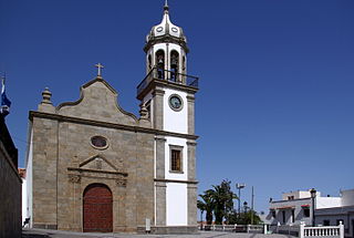
Granadilla de Abona is a municipality of Tenerife, located in the south of the island, occupying an area of 155 square kilometers. Its population in 2013 was 43,608. In recent years, the population has greatly increased due to an influx of immigrants, from Western Sahara, Colombia, Cuba, and other African and Latin American countries.
Fasnia is a town and a municipality in the eastern part of the Spanish island of Tenerife, one of the Canary Islands, and part of the province of Santa Cruz de Tenerife. The municipality extends for 45.1 square kilometers (17.4 sq mi) from the mountainous interior to the beaches on the Atlantic. Its population is 2,873 (2013). The TF-1 motorway passes through the municipality.

Adeje is a town and municipality in the southwestern part of the island of Tenerife, one of the Canary Islands, and part of the province of Santa Cruz de Tenerife, Spain. The town Adeje is located 4 km from the coast, 8 km north of the resort town Los Cristianos, 60 km southwest of the island capital Santa Cruz de Tenerife and about 17 km northwest of Tenerife South Airport.

Malpaís de Güímar or Badlands of Guimar consist of a volcanic cone, subsidiary cones, and several basaltic lava flows in the Güímar municipality on the island of Tenerife, in the Canary Islands, Spain. They total in area about 290 hectares. The lava flows are quite recent, with the typical ʻaʻā type less than 10,000 years old. The large cone is called Montaña Grande and reaches a height of 276 m (906 ft).

Museo de la Naturaleza y Arqueología (MUNA), is a museum-based in Santa Cruz de Tenerife, Tenerife,. It contains many significant archaeological finds and is considered the best repository of objects from the Pre-Castilian Canary Islands. The museum also houses significant paleontological, botanical, entomological, and marine and terrestrial vertebrate collections, and is considered the best Natural Library of the Canary Islands.

The Mummy of San Andrés is a human mummy belonging to the Guanche culture, who were the ancient inhabitants of the Canary Islands, Spain.

The conquest of the Canary Islands by the Crown of Castille took place between 1402 and 1496 and described as the first instance of European settler colonialism in Africa. It can be divided into two periods: the Conquista señorial, carried out by Castilian nobility in exchange for a covenant of allegiance to the crown, and the Conquista realenga, carried out by the Spanish crown itself, during the reign of the Catholic Monarchs.

The Barranco de Badajoz or Chamoco is a ravine on the island of Tenerife, in the province of Santa Cruz de Tenerife, part of the municipality of Güímar in the southeast of the island.
Masca Gorge is a narrow valley in the north-west of the island of Tenerife. The gorge is situated within the Teno Massif. The gorge is a popular tourist destination due to its dramatic scenery and unique geology. An eight-kilometre long walking trail begins at Masca village and continues for the length of the gorge to finish at Masca beach, approximately ten kilometres from the north-west tip of Tenerife.

The Guayadeque ravine, in Spanish Barranco de Guayadeque, is a ravine-type valley located on the Spanish municipalities of Ingenio and Agüimes, in the province of Las Palmas on Grand Canary island, off the coast of Morocco.

Cueva del Agua is a small village of the Spanish municipality of Garafia in the north-east of the island of La Palma, province of Santa Cruz de Tenerife, in the Canary Islands off the Moroccan coast.

 Information board in Spanish
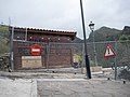 Fence at the entrance to the trail after the accident in 2009
 Detail of the sign
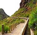 Trail - first part
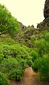 Trail - second part
 Trail - third part
 End of the trail


