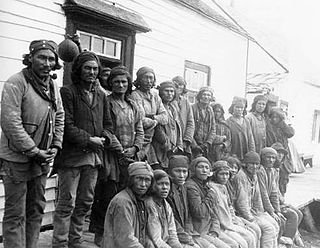
The Innu / Ilnu or Innut / Innuat / Ilnuatsh ("people"), formerly called Montagnais from the French colonial period, are the Indigenous Canadians who inhabit the territory in the northeastern portion of the present-day province of Labrador and some portions of Quebec. They refer to their traditional homeland as Nitassinan or Innu-assi.

The Algonquin people are an Indigenous people who now live in Eastern Canada and parts of the United states. They speak the Algonquin language, which is part of the Algonquian language family. Culturally and linguistically, they are closely related to the Odawa, Potawatomi, Ojibwe, Mississaugas, and Nipissing, with whom they form the larger Anicinàpe (Anishinaabeg) group. Algonquins are known by many names, including Omàmiwinini and Abitibiwinni or the more generalised name of Anicinàpe.
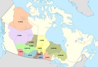
Indigenous peoples in Quebec total eleven distinct ethnic groups. The one Inuit community and ten First Nations communities number 141,915 people and account for approximately two per cent of the population of Quebec, Canada.

Kanesatake is a Mohawk settlement on the shore of the Lake of Two Mountains in southwestern Quebec, Canada, at the confluence of the Ottawa and Saint Lawrence rivers and about 48 kilometres (30 mi) west of Montreal. People who reside in Kanehsatà:ke are referred to as Mohawks of Kanesatake. As of 2022, the total registered population was 2,751, with a total of about 1,364 persons living on the territory. Both they and the Mohawk of Kahnawake, Quebec, a reserve located south of the river from Montreal, also control and have hunting and fishing rights to Doncaster 17 Indian Reserve.
Crown–Indigenous Relations and Northern Affairs Canada is the department of the Government of Canada responsible for Canada's northern lands and territories, and one of two departments with responsibility for policies relating to Indigenous peoples in Canada.

The Listuguj Mi'gmaq First Nation is a Mi'gmaq First Nations band government with a registered population (2022) of 4,248 members, most of whom are of Mi'kmaq ancestry. The name Listuguj, is the origin for the name of the Restigouche River, as well as other nearby places also carrying the name Restigouche. Listuguj is also used as a name for one of the Míkmaq orthographies. Its southern border is adjacent to Pointe-à-la-Croix, Quebec.
Inuit Tapiriit Kanatami, previously known as the Inuit Tapirisat of Canada, is a nonprofit organization in Canada that represents over 65,000 Inuit across Inuit Nunangat and the rest of Canada. Their mission is to "serve as a national voice protecting and advancing the rights and interests of Inuit in Canada."
A tribal council is an association of First Nations bands in Canada, generally along regional, ethnic or linguistic lines.

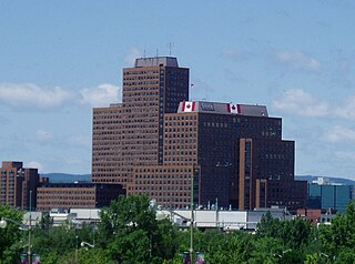
The Chaudière Falls, also known as the Kana:tso or Akikodjiwan Falls, are a set of cascades and waterfall in the centre of the Ottawa-Gatineau metropolitan area in Canada where the Ottawa River narrows between a rocky escarpment on both sides of the river. The location is just west of the Chaudière Bridge and Booth-Eddy streets corridor, northwest of the Canadian War Museum at LeBreton Flats and adjacent to the historic industrial E. B. Eddy complex. The islands surrounding the Chaudière Falls, counter-clockwise, are Chaudière Island, Albert Island, little Coffin Island was just south of Albert Island but is now submerged, Victoria Island and Amelia Island,, Philemon Island was originally called the Peninsular Village by the Wrights but became an island when the timber slide was built in 1829 it is now fused to south shore of City of Gatineau, and Russell Island, now submerged, was at the head of the Falls before the Ring dam was built. The falls are about 60 metres (200 ft) wide and drop 15 metres (49 ft). The area around the falls was once heavily industrialized, especially in the 19th century, driving growth of the surrounding cities.
The Numbered Treaties are a series of eleven treaties signed between the First Nations, one of three groups of Indigenous Peoples in Canada, and the reigning monarch of Canada from 1871 to 1921. These agreements were created to allow the Government of Canada to pursue settlement and resource extraction in the affected regions, which includes the entirety of modern-day Alberta, Manitoba, and Saskatchewan, as well as parts of modern-day British Columbia, Ontario, the Northwest Territories, Nunavut, and Yukon. These treaties expanded the Dominion of Canada resulting in the displacement of Indigenous populations for large tracts of land in exchange for promises made to the indigenous people of the area. These terms were dependent on individual negotiations and so specific terms differed with each treaty.
The Agreement Respecting a New Relationship Between the Cree Nation and the Government of Quebec is an agreement between the Government of Quebec, Canada, and the Grand Council of the Crees. It was signed on February 7, 2002 in Waskaganish, Jamésie, Quebec, after decades of court battles between the Cree and the Government of Quebec. The name was inspired by the 1701 Great Peace of Montreal, also known as "La Paix des Braves".
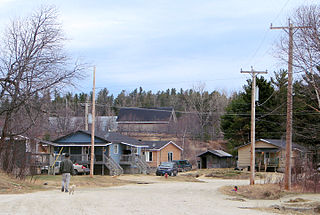
Apitipi Anicinapek Nation, formerly known as Wahgoshig First Nation, is an Algonquin Anicinape community, located near Matheson in Cochrane District in northeastern Ontario, Canada. In January 2008, the First Nation had 270 people registered with the nation, of which their on-reserve population was 121.

Kitigan Zibi is a First Nations reserve of the Kitigan Zibi Anishinabeg First Nation, an Algonquin band. It is situated near the confluence of the Désert and Gatineau Rivers, and borders south-west on the Town of Maniwaki in the Outaouais region of Quebec, Canada. Having a total area of 210.09 km2 (81.12 sq mi), it is the largest Algonquin Nation in Canada in both area and population.
Rapid Lake is a First Nation reserve on the western shore of Cabonga Reservoir in the Outaouais region of Quebec, Canada. It belongs to the Algonquins of Barriere Lake of the Algonquin Nation.

Victoria Island is an island in the Ottawa River, located north of LeBreton Flats, 1 km west of Parliament Hill in Ottawa, Ontario. The island is "a place of special significance" to the local Algonquian peoples, who use the island for ceremonial purposes and for protests. It is part of an archipelago of islands below Chaudière Falls, which also includes the former Philemon Island, Chaudière Island, Amelia Island and Albert Island.

Idle No More is an ongoing protest movement, founded in December 2012 by four women: three First Nations women and one non-Native ally. It is a grassroots movement among the Indigenous peoples in Canada comprising the First Nations, Métis and Inuit peoples and their non-Indigenous supporters in Canada, and to a lesser extent, internationally. It has consisted of a number of political actions worldwide, inspired in part by the liquid diet hunger strike of Attawapiskat Chief Theresa Spence and further coordinated via social media. A reaction to alleged legislative abuses of Indigenous treaty rights by then Prime Minister Stephen Harper and the Conservative federal government, the movement takes particular issue with the omnibus bill Bill C-45. The popular movement has included round dances in public places and blockades of rail lines.
Indigenous or Aboriginal self-government refers to proposals to give governments representing the Indigenous peoples in Canada greater powers of government. These proposals range from giving Aboriginal governments powers similar to that of local governments in Canada to demands that Indigenous governments be recognized as sovereign, and capable of "nation-to-nation" negotiations as legal equals to the Crown, as well as many other variations.
Co-management, also known as community-based management, community-based resource management, cooperative management, joint management, and collaborative management, in the broadest terms refers to the administration of a particular place or resource being shared between multiple local and state management systems. Although co-management encompasses a spectrum of power-sharing arrangements, in the Canadian context it typically refers to agreements between government agencies and representatives of Indigenous peoples in Canada to jointly make land use and resource management decisions about a tract of government-controlled land or resource (e.g.fishery.).
Algonquins of Barriere Lake are an Algonquin First Nation in Quebec, Canada. They primarily live on the Indian reserve of Rapid Lake in Outaouais. In 2017 the band had a registered population of 792 members. It is part of Algonquin Nation Programs and Services Secretariat.
Indigenous peoples in Canada demand to have their land rights and their Aboriginal titles respected by the Canadian government. These outstanding land claims are some of the main political issues facing Indigenous peoples today.