
Serekunda is the largest urban centre in The Gambia. It is situated close to the Atlantic coast, 13 km (8 mi) south-west of the capital, Banjul, and is formed of nine villages which have grown together into a larger urban area.

Bakau is a town on the Atlantic coast of Gambia, west of Gambia's capital city of Banjul. It is known for its botanical gardens, its crocodile pool Bakau Kachikally and for the beaches at Cape Point. Bakau is the first major suburb outside Banjul and the most developed town in the Gambia. Close to Bakau and Banjul is Gambia's largest city, Serekunda.
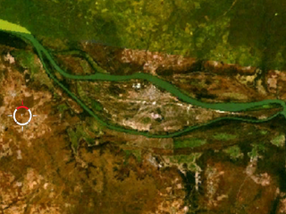
MacCarthy Island, originally known as Lemain Island and officially named Janjanbureh Island, is an island located approximately 170 miles (272 km) upriver from the mouth of the Gambia River, in eastern Gambia, in the Janjanbureh District. Located on the island is the second-largest town in the country, Janjanbureh, but on many maps it still appears by its European name of Georgetown. In addition to being a destination for some wildlife tourists, the island is also the home of Gambia's largest prison.

Upper River was one of the five Divisions of the Gambia. Its capital was Basse Santa Su. It was subsequently reorganised as the Basse Local Government Area, without any change in the area covered.

Foday Musa Suso is a Gambian musician and composer. He is a member of the Mandinka ethnic group, and is a griot. Griots are the oral historians and musicians of the Mandingo people who live in several west African nations. Griots are a living library for the community providing history, entertainment, and wisdom while playing and singing their songs. It is an extensive verbal and musical heritage that can only be passed down within a griot family.

Fulladu East was one of the four districts of the Upper River Division of the Gambia. The Upper River Division is now the Basse Local Government Area, and the former Fulladu East District is now divided into a Basse Fulladu East District, a Jimara District and a Tumana District.
Wuli District was one of the four districts of the former Upper River Division of the Gambia. The Upper River Division is now the Basse Local Government Area. Wuli was established as a parliamentary constituency in 1962 and was divided into Wuli West District and Wuli East District in 1987. The name derives from the historical region and former Mandinka kingdom of Wuli.
Baja Kunda is a town in eastern Gambia. It is located in Wuli East District in the Upper River Division. As of 2008, it has an estimated population of 5,924. Located just south of the north bank highway, Baja Kunda boasts an elementary, secondary, and senior secondary school as well as the main health center in the Wuli East district. A few kilometers to the southwest is the old river port of Fattatenda.
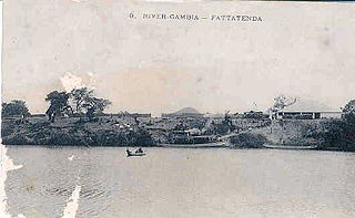
Fattatenda is a small village in eastern Gambia on the Gambia River. It is located in Wuli District in the Upper River Divisiont, a few kilometers southwest of the much larger village of Baja Kunda. As of 2009, it has an estimated population of 49.
Banni is a village in the Gambia. It is located in Wuli District in the Upper River Division. As of 2009, it has an estimated population of 461.
Bantango Koto is a village in the Gambia. It is located in Wuli District in the Upper River Division. As of 2009, it has an estimated population of 327.
Bantunding is a village in the Gambia. It is located in Wuli East District in the Upper River Division. As of 2009, it has an estimated population of 1114. Bantunding is home to several traditional rulers locally known as (Seyfo). The last chief from the village is called Sergeant Madi Wally. Madi Wally’ Father Jumu Wally also served as chief.
Bohum Kunda is a town in the Gambia. It is located in Fulladu East District in the Upper River Division. As of 2009, it has an estimated population of 722.
Boro Dampha Kunda is a town in the Gambia. It is located in Wuli District in the Upper River Division. As of 2009, it has an estimated population of 353.
Boro Kanda Kassy is a town in the Gambia. It is located in Wuli District in the Upper River Division. As of 2009, it has an estimated population of 1091.
Chamoi Bunda is a town in the Gambia. It is located in Wuli District in the Upper River Division. As of 2009, it has an estimated population of 785.
The Barrakunda Falls or Barra Kunda Falls is a waterfall located in the Tambacounda region of Senegal, 500 kilometres (300 mi) upstream from the mouth of the Gambia River.

Latri Kunda is part of the Kanifing District, and a suburb of Sere Kunda in the Gambia.
Sutukoba, sometimes referred to as Sutuko, is a village in The Gambia located in the Upper River Region, 332 km east of the capital Banjul and 38 km northeast of the regional capital Basse Santa Su. The population in 2013 was 3317.