Last updated The location of the Barther BoddenA zeesenboot on the Großen Kirr
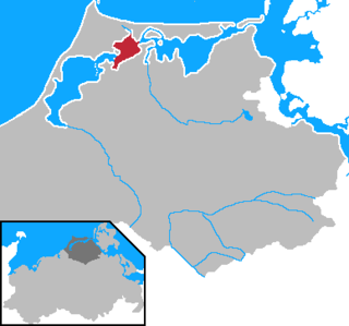
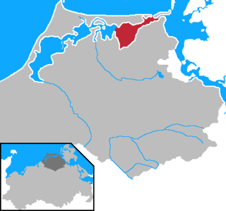
The Barther Bodden (German for Barth Lagoon) is a bodden water between the Zingst peninsula and the mainland town of Barth. It is a brackish lagoon that is part of the Darss-Zingst Bodden Chain. Its largest inflow is the Barthe stream.
Large parts of the Barther Bodden have a depth of less than 2 meters, so that shipping is very restricted. Today, it is limited almost exclusively to sport boats and pleasure cruisers. To the north is the Zingster Strom, the river-like section of the bodden south of Zingst. Here the bodden reaches its greatest depths of over six metres.
To the northwest lie the well-known islands of Kirr and Barther Oie, both important breeding areas for gulls, terns, waterfowl and waders. These rise just a few centimetres above the water level of the bodden and are out of bounds to visitors. The Kirr is used as cattle pasture and, during the autumn migration is an important stopover for cranes.
The Western Pomerania Lagoon Area National Park is Mecklenburg-Vorpommern's largest national park, situated at the coast of the Baltic Sea. It consists of several peninsulas, islands and lagoon shore areas in the Baltic Sea, belonging to the district of Vorpommern-Rügen.
The Darß or Darss is the middle part of the peninsula of Fischland-Darß-Zingst on the southern shore of the Baltic Sea in the German state of Mecklenburg-Western Pomerania. The peninsula's name comes from the names of the three regions making up the peninsula. There is a large forest in the Darß. In recent times, the name "Darß" has also been used to refer to the entire peninsula.
Zingst is the easternmost portion of the three-part Fischland-Darß-Zingst Peninsula, located in Mecklenburg-Vorpommern, Germany, between the cities of Rostock and Stralsund on the southern shore of the Baltic Sea.
Fischland-Darß-Zingst or Fischland-Darss-Zingst is a 45 km (28 mi) long peninsula in the coastal district of Vorpommern-Rügen, in the German state of Mecklenburg-Vorpommern. The three parts of the peninsula, from west to east, are Fischland, Darß and Zingst.
Bodden are briny bodies of water often forming lagoons, along the southwestern shores of the Baltic Sea, primarily in Germany's state of Mecklenburg-Vorpommern. These lagoons can be found especially around the island of Rügen, Usedom and the Fischland-Darss-Zingst peninsula. Some of them are protected reserves, forming the Western Pomerania Lagoon Area National Park.
Vorpommern-Rügen is a district in the north of Mecklenburg-Vorpommern, Germany. It is bounded by the Baltic Sea and the districts Vorpommern-Greifswald, Mecklenburgische Seenplatte and Rostock. The district seat is the Hanseatic city of Stralsund.
The Bodstedter Bodden is a lagoon, of the type known as a bodden, that is part of the Darss-Zingst Bodden Chain and the Western Pomerania Lagoon Area National Park in northeastern Germany. It lies south of the peninsula of Fischland-Darß-Zingst on the coast of Mecklenburg-Vorpommern. The heavily indented, reed fringed shoreline forms a picturesque landscape with the result that the villages near the shore are popular tourist destinations.
The Darss-Zingst Bodden Chain is a waterbody on the Baltic Sea coast northeast of Rostock in Germany. It consists of a string of several lagoons or bodden arranged in an east-west direction that are separated from the open sea by the Fischland-Darß-Zingst peninsula. The surface area of these lagoons is 197 km² and the average water depth is only about two metres.
The Großer Jasmunder Bodden belongs to the Northern Rügener Boddens and is a water body on the southern edge of the Baltic Sea in the German state of Mecklenburg-Vorpommern. It is a bodden, a type of lagoon that occurs in northern Europe especially on the coast of Pomerania. It lies within the island of Rügen, is around 14 kilometres long, an average of six kilometres wide and is up to nine metres deep with an average depth of 5.3m. The Großer Jasmunder Bodden has an area of 58.6 square kilometres; if the Breetzer Bodden, Breeger Bodden, Lebbiner Bodden, Neuendorfer Wiek and Tetzitzer See are included the total area of water comes to over 94 square kilometres.
The Schaproder Bodden is a bodden on the Baltic Sea coast between the island of Hiddensee in the west and the islands of Rügen and Ummanz in the east. To the north the Schaproder Bodden is linked to the Vitter Bodden by the so-called Trog between the Fährinsel and the Stolper Haken of Rügen island. To the south the bodden transitions into the Kubitzer Bodden. A boundary would be the line between the southern tips of the Hiddensee and Ummanz or the link from the Geller Haken - Insel Heuwiese.
The Grabow is a bodden - a lagoon-like waterbody - off the Baltic Sea south of the Zingst and Großer Werder peninsulas and the island group of Kleiner Werder.
The Saaler Bodden forms the southwestern part of the Darss-Zingst Bodden Chain and lies east of the Fischland peninsula about 30 kilometres northeast of Rostock. Its average depth is around two metres, which restricts angling and the use of pleasure craft. It is a lagoon-like stretch of water known as a bodden, which is typical of this part of the Baltic coastline. South of the Saaler Bodden is the town of Ribnitz-Damgarten, which is divided into two by the mouth of the 72 kilometre long Recknitz river. This southern part of the bodden is called the Lake Ribnitz.
The Permin is a bay in the Saaler Bodden lagoon south of Wustrow in northeast Germany. Originally the Permin was a channel between the Saaler Bodden and the Baltic Sea and the southern estuarine channel of the River Recknitz. It borders on the Fischland in the south.
Kirr is an island in the Darss-Zingst Bodden Chain south of the Zingst Peninsula on the German Baltic Sea coast. It is separated from the peninsula by the Zingster Strom. The island is a nature reserve within the Western Pomerania Lagoon Area National Park. It was formerly and is sometimes still called Großer Kirr or Große Kirr. This is to distinguish it from the northwestern part of the island, which was still a separate albeit much smaller island in the Zingster Strom in the second half of the 20th century, that used to be called Kleiner Kirr or Kleine Kirr.
The uninhabited island of Barther Oie belongs to the German federal state of Mecklenburg-Vorpommern and lies in the lagoon of Barther Bodden, between the town of Barth and the Baltic seaside resort of Zingst.
The peninsula of Großer Werder lies southwest of the Hiddensee, west of the island of Bock and is joined to the peninsula of Zingst to the east. It belongs to the district of Vorpommern-Rügen in northeast Mecklenburg-Vorpommern in Germany.
The Prerower Strom, Prerow Strom or Prerowstrom is an arm of the Baltic Sea in northeast Germany. It begins near the island of Schmidtbülten in the Bodstedter Bodden and winds its way through the countryside of the peninsula of Fischland-Darß-Zingst, where it separates Darß from the peninsula of Zingst. It ends at the harbour of the village of Prerow that gives it its name. The Prerower Strom is part of the Western Pomerania Lagoon Area National Park.
Fischland is an isthmus on the southern Baltic Sea coast on the Bay of Mecklenburg in northeastern Germany. It is part of the peninsula of Fischland-Darß-Zingst. Fischland was an island until the 14th century and was bounded by the navigable estuarine branches of the River Recknitz: the Permin in the south and the Loop in the north. In more recent times its southern boundary has usually been considered to be the Recknitz Meadowland and the Rostock Heath. To the west and east its boundaries are more obvious: on the one side is its active cliffed coast on the Baltic, and on the other the coastline alongside the Saaler Bodden, only a few centimetres above sea level. Fischland is about 5 km long, between 500 metres and 2 km wide and runs from southwest to northeast.
The Wittow Ferry is a ferry service for foot passengers and vehicles from the heart of the German Baltic Sea island of Rügen, the Muttland, to the peninsula of Wittow to the north. It has also given its name to the parish of Wittower Fähre in the municipality of Wiek. This lies on the Rassower Strom at the tip of the tongue of land between the lagoons of Wieker Bodden and Breetzer Bodden on its northern shore. On the southern shore the ferry landing stage is located between the villages of Vaschvitz and Fischersiedlung in the municipality of Trent.
The Zingster Strom is a distinctive, river-like arm of the Barther Bodden lagoon, south of the Zingst peninsula on Germany's Baltic Sea coast. It lies between the island of Kirr and the Zingst and runs from east to west in a semi-circular arc, both ends being open to the south. It is less than one hundred metres wide in places and about three kilometres long. Unlike its rather shallow neighbouring waterbodies it is over six metres deep in places. At its northernmost point lies the village of Zingst with its harbour and a water fowl roosting area. Two smaller islands, Brunstwerder and Gänsebrink, are located in the Strom. The Strom used to have direct access to the Baltic via the Alte Stramminke, a former inlet.
This page is based on this Wikipedia article Text is available under the CC BY-SA 4.0 license; additional terms may apply. Images, videos and audio are available under their respective licenses.