
San Bernardino County, officially the County of San Bernardino and sometimes abbreviated as S.B. County, is a county located in the southern portion of the U.S. state of California, and is located within the Inland Empire area. As of the 2020 U.S. Census, the population was 2,181,654, making it the fifth-most populous county in California and the 14th-most populous in the United States. The county seat is San Bernardino.

Big Bear City is an unincorporated community in San Bernardino County, California, United States along the east shore of Big Bear Lake and surrounded by the San Bernardino National Forest. It is 27 miles (43 km) northeast of the city of San Bernardino, and immediately east of the incorporated city of Big Bear Lake. For statistical purposes, the United States Census Bureau has defined Big Bear City as a census-designated place (CDP). Its population was 12,304 at the 2010 census, up from 5,779 at the 2000 census. Big Bear City is mostly residential, with smaller houses and cabins laid out in typical square block fashion. Big Bear is on the Pacific Crest Trail.

Big Bear Lake is a city in San Bernardino County, California, located in the San Bernardino Mountains along the south shore of Big Bear Lake, and surrounded by the San Bernardino National Forest. The city is about 25 miles (40 km) northeast of the city of San Bernardino, and immediately west of the unincorporated town of Big Bear City. The population was approximately 5,019 at the 2010 census, down from 5,438 at the 2000 census. However, as a popular year-round resort destination, the actual number of people staying in or visiting the greater Big Bear Valley area regularly surges to over 100,000 during many weekends of the year.

Running Springs is a census-designated place (CDP) in San Bernardino County, California, United States. The population was 5,268 at the 2020 census, up from 4,862 at the 2010 census. Running Springs is situated 17 miles west of the city of Big Bear Lake.

Big Bear Lake is a reservoir in the western United States, located in the San Bernardino Mountains in San Bernardino County, California. It is a snow and rain-fed lake, having no other means of tributaries or mechanical replenishment.

The San Bernardino Mountains are a high and rugged mountain range in Southern California in the United States. Situated north and northeast of San Bernardino and spanning two California counties, the range tops out at 11,503 feet (3,506 m) at San Gorgonio Mountain – the tallest peak in Southern California. The San Bernardinos form a significant region of wilderness and are popular for hiking and skiing.

State Route 38 is a mostly rural and scenic state highway in the U.S. state of California, connecting Interstate 10 in Redlands with State Route 18 in the Big Bear Lake area. It is one of the primary routes into the San Bernardino Mountains. Despite the orientation of its alignment, SR 38 is assigned in a west–east direction.

The Angeles National Forest (ANF) of the U.S. Forest Service is located in the San Gabriel Mountains and Sierra Pelona Mountains, primarily within Los Angeles County in southern California. The ANF manages a majority of the San Gabriel Mountains National Monument.

Angelus Oaks is an unincorporated community in San Bernardino County, California, United States, and has a population of 535 as of the 2010 U.S. Census, up from an estimated population of 312 in 2000. It is surrounded by the San Bernardino National Forest and located east of San Bernardino on California State Route 38.

The San Bernardino National Forest is a United States national forest in Southern California encompassing 823,816 acres (3,333.87 km2) of which 677,982 acres (2,743.70 km2) are federal. The forest is made up of two main divisions, the eastern portion of the San Gabriel Mountains and the San Bernardino Mountains on the easternmost of the Transverse Ranges, and the San Jacinto and Santa Rosa Mountains on the northernmost of the Peninsular Ranges. Elevations range from 2,000 to 11,499 feet. The forest includes seven wilderness areas: San Gorgonio, Cucamonga, San Jacinto, South Fork, Santa Rosa, Cahuilla Mountain and Bighorn Mountain. Forest headquarters are located in the city of San Bernardino. There are district offices in Lytle Creek, Idyllwild, and Fawnskin.
California's 23rd congressional district is a congressional district in the U.S. state of California. The district is represented in the 118th United States Congress by Jay Obernolte.
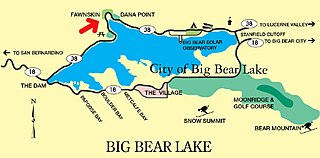
Fawnskin is an unincorporated community in San Bernardino County, California, United States. It is located on the northwest side of Big Bear Valley, in the heart of the San Bernardino Mountains, at an altitude of 6,827 feet (2,081 m). The tiny community has a "permanent" population of 380, and many vacation homes that range from multi-million dollar mansions to decaying log cabins. Fawnskin has its own US Post Office, established on May 18, 1918, but to this day, mail must be picked up because there is no delivery service.
Green Valley Lake is an unincorporated community in San Bernardino County, California. It has a population of about 300. The ZIP Code is 92341 and the community is inside area code 909.

Jenks Lake is a lake in the San Bernardino National Forest near Angelus Oaks in San Bernardino County, California. The lake offers several fish species including bass, catfish, bluegill, and rainbow trout. Trout season usually runs from April to October.

The San Bernardino County Sheriff-Coroner's Department (SBSD) serves San Bernardino County, California, which is geographically the largest county in the continental United States and is headquartered in San Bernardino. SBSD provides law enforcement services to the unincorporated areas of the county and contract law enforcement services to 14 of the county's cities, including Rancho Cucamonga and Chino Hills, serving a total of 1,029,466 of the county's 2 million residents. The department also operates the county jail system, provides marshal services for the county superior courts, and has other specialized divisions to serve the citizens of San Bernardino County.
The Lake Fire was a wildfire that burned in the San Bernardino National Forest. The fire started on June 17, 2015, and burned over 31,359 acres before it was fully contained on July 21, 2015.

Sand to Snow National Monument is a U.S. National Monument located in San Bernardino County and northern Riverside County, Southern California.
The Holcomb Fire was a wildfire that burned due north of Big Bear Lake near Highway 18 in the San Bernardino National Forest in San Bernardino County, California. Within several days, the fire would consume some 1,500 plus acres as it threatened the areas of Baldwin Lake and Highway 18. However, while the fire rapidly grew in size, the head of the fire was seen to be moving away from structures, thus leaving evacuated areas under voluntary evacuation.
Bluff Lake is a lake in the Big Bear Valley of the San Bernardino Mountains, in San Bernardino County, California. It is located southwest of Big Bear Lake reservoir and Big Bear City.

The El Dorado Fire was a wildfire that burned 22,744 acres in San Bernardino and Riverside counties of California from September to November 2020. It was ignited on September 5 by a pyrotechnic device at a gender reveal party in El Dorado Ranch Park; it quickly spread to the San Gorgonio Wilderness Area of the San Bernardino National Forest. Burning over a 71-day period, the fire destroyed 20 structures and resulted in one firefighter fatality, for which the couple hosting the party were charged with involuntary manslaughter.

