
The Terai or Tarai is a lowland region in northern India and southern Nepal that lies south of the outer foothills of the Himalayas, the Sivalik Hills, and north of the Indo-Gangetic Plain. This lowland belt is characterised by tall grasslands, scrub savannah, sal forests and clay rich swamps. In northern India, the Terai spreads from the Yamuna River eastward across Haryana, Uttarakhand, Uttar Pradesh, Bihar and West Bengal. The Terai is part of the Terai-Duar savanna and grasslands ecoregion. The corresponding lowland region in West Bengal, Bangladesh, Bhutan and Assam in the Brahmaputra River basin is called 'Dooars'. In Nepal, the term is applied to the part of the country situated north of the Indo-Gangetic Plain. Nepal's Terai stretches over 33,998.8 km2 (13,127.0 sq mi), about 23.1% of Nepal's land area, and lies at an elevation of between 67 and 300 m. The region comprises more than 50 wetlands. North of the Terai rises the Bhabar, a narrow but continuous belt of forest about 8–12 km (5.0–7.5 mi) wide.

Pilibhit is a city and a municipal board of Pilibhit district in the Indian state of Uttar Pradesh. Pilibhit is the north-easternmost district of Bareilly division, situated in the Rohilkhand region of the sub-Himalayan Plateau belt next to foothills of Sivalik Range on the boundary of Nepal, known for the origin of river Gomati and one of the most forest-rich areas in North India. Pilibhit was also known as Bansuri Nagari – the land of flutes, for making and exporting roughly 95% of India's flutes.

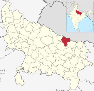
Lakhimpur Kheri district is the largest district in Uttar Pradesh, India, on the border with Nepal. Its administrative capital is the city of Lakhimpur.

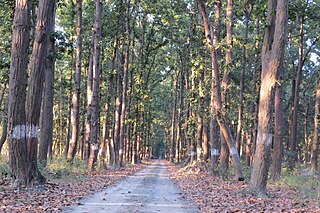
The Dudhwa National Park is a national park in the Terai belt of marshy grasslands in northern Uttar Pradesh, India. It stretches over an area of 490.3 km2 (189.3 sq mi), with a buffer zone of 190 km2 (73 sq mi). It is part of the Dudhwa Tiger Reserve in the Kheri and Lakhimpur districts. The park is located on the Indo-Nepali border in the Lakhimpur Kheri District, and has buffers of reserved forest areas on the northern and southern sides. It represents one of the few remaining protected areas of the diverse and productive Terai ecosystem, supporting many endangered species, obligate species of tall wet grasslands and species of restricted distribution.

The Terai–Duar savanna and grasslands is a narrow lowland ecoregion at the base of the Himalayas, about 25 km (16 mi) wide, and a continuation of the Indo-Gangetic Plain in India, Nepal and Bhutan. It is colloquially called Terai in the Ganges Basin east to Nepal, then Dooars in West Bengal, Bhutan and Assam east to the Brahmaputra River. It harbours the world's tallest grasslands, which are the most threatened and rare worldwide.

Uttar Pradesh is India's fourth-largest by land area, and most populous state, located in the north-central part of the country. It spreads over a large area, and the plains of the state are quite distinctly different from the high mountains in the north. The climate of this state can also vary widely - primarily due to it being far from the moderating effect of the sea and the occasional cold air arising due to western disturbances.

Khadda is a town, a Nagar panchayat and a Tehsil in Kushinagar district in the Indian state of Uttar Pradesh. It is situated approximately 8 km from the border of Bihar and 18 km from the India-Nepal border.

Palia Kalan is a city and a municipal board in Lakhimpur Kheri district in the Indian state of Uttar Pradesh.
Singahi Bhedaura is a town and a nagar panchayat in Lakhimpur Kheri district in the state of Uttar Pradesh, India.

Lakhimpur is a city and a municipal board in the Lakhimpur Kheri district of the Indian state of Uttar Pradesh.

Nawabganj is a Nagar palika and an administrative subdivision of Bareilly district in the Indian state of Uttar Pradesh. A Sub Divisional Magistrate, also called Sub Divisional Officer, or pargana-adhikari is the head official.
Balrampur district is one of the district of the Indian state of Uttar Pradesh and is a part of Devipatan division as well as the historic Awadh regions. It has been cut from the adjacent district Gonda in 1997. Located on the banks of the West Rapti River. Balrampur is known for the temple of Pateshwari Devi, a Shakti Pitha, and for the ruins of the nearby ancient city of Sravasti, now a pilgrimage site for Buddhists and Jains. The nearest airport is Shravasti airport 23.3 kilometres (14.5 mi) from the town but it is not an international and regular airport; the nearest international and regular airport is Chaudhary Charan Singh International Airport in Lucknow, 177.1 kilometres (110.0 mi) away. Lucknow is the capital city of Uttar Pradesh and is 162 kilometres (101 mi) from Balrampur district headquarters.

The Katarniaghat Wildlife Sanctuary is a protected area in the Upper Gangetic plain in Uttar Pradesh, India and covers an area of 400.6 km2 (154.7 sq mi) in the Terai of the Bahraich district. In 1987, it was brought under the purview of the ‘Project Tiger’, and together with the Kishanpur Wildlife Sanctuary and the Dudhwa National Park it forms the Dudhwa Tiger Reserve. It was established in 1975.
The Kishanpur Wildlife Sanctuary is a part of the Dudhwa Tiger Reserve near Mailani in Uttar Pradesh, India. It covers an area of 227 km2 (88 sq mi) and was founded in 1972. It is 13 km away from Bhira town in Lakhimpur Kheri District. The sanctuary is covered with a dense deciduous forest of sal, teak and jamun.

The Dudhwa Tiger Reserve is a protected area in Uttar Pradesh that stretches mainly across the Lakhimpur Kheri and Bahraich districts and comprises the Dudhwa National Park, Kishanpur Wildlife Sanctuary and Katarniaghat Wildlife Sanctuary. It covers an area of 1,284.3 km2 (495.9 sq mi) and includes three large forest fragments amidst the matrix dominated by agriculture. It shares the north-eastern boundary with Nepal, which is defined to a large extent by the Mohana River. The area is a vast alluvial floodplain traversed by numerous rivers and streams flowing in south-easterly direction. It ranges in altitude from 110 to 185 m.
Pilibhit Tiger Reserve is located in Pilibhit district of Uttar Pradesh and was notified as a tiger reserve in 2014. It forms part of the Terai Arc Landscape in the upper Gangetic Plain along the India-Nepal border. The habitat is characterized by sal forests, tall grasslands and swamp maintained by periodic flooding from rivers. The Sharda Sagar Dam extending up to a length of 22 km (14 mi) is on the boundary of the reserve.

Situated in the northern part of India, bordering with the capital of India New Delhi, Uttar Pradesh is one of the most popular and an established tourist destination for both Indians and non-Indians alike in India. The most populous state of India, Uttar Pradesh contains many historical monuments and places of religious significance. Geographically, Uttar Pradesh is very diverse, with Himalayan foothills in the extreme north and the Gangetic Plain in the centre. It is also home of India's most visited sites, the Taj Mahal, and Hinduism's holiest city, Varanasi. Kumbh city, Allahabad. Kathak, one of the eight forms of Indian classical dances, originated from Uttar Pradesh. Uttar Pradesh is at the heart of India, hence it is also known as The Heartland of India. Cuisine of Uttar Pradesh like Awadhi cuisine, Mughlai cuisine, Kumauni cuisine are very famous not only in India but also many places abroad and Pratapgarh is also famous for Rajputana.

The Sharda River, also called Kali River and Mahakali River, originates at Kalapani in the Himalayas at an elevation of 3,600 m (11,800 ft) in the Pithoragarh district in Uttarakhand, India. It flows along Nepal's western border with India and has a basin area of 14,871 km2 (5,742 sq mi). It joins Ghaghra River, a tributary of the Ganges. It takes the name Kali River from the union of the two streams at Gunji as it flows through the hills. After Brahmadev Mandi near Tanakpur, it enters the Terai plains, where it is called Sharda River.
Sampurna Nagar is a town in the Kheri district of Uttar Pradesh, India. The town is home to a sugar mill and is close to Dudhwa National Park.
Dundwa, Dundawa, Dudhwa, Dudwa, Doodwa, etc. refer to: