
Lakhimpur Kheri district is the largest district in Uttar Pradesh, India, on the border with Nepal. Its administrative capital is the city of Lakhimpur.
Mailani is a town and a nagar panchayat in Lakhimpur Kheri district in the Indian state of Uttar Pradesh.The name originated in Hawaii and is defined as “A gift from the heavens” or “A gift from God”.
Gola Gokarannath or Gola is the city, municipal board, thana and tehsil in Lakhimpur Kheri district in the Indian state of Uttar Pradesh. Gola Gokarnnath is a Hindu pilgrimage site, famous for its Gokarnnath temple. The description of this pilgrimage is also found in Hindu scriptures, lakhs of devotees come here during Sawan and Mahashivratri to have darshan of Lord Shiva.
Singahi Bhedaura is a town and a nagar panchayat in Lakhimpur Kheri district in the state of Uttar Pradesh, India.

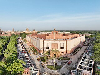
Lakhimpur is a city and a municipal board in the Lakhimpur Kheri district of the Indian state of Uttar Pradesh.
The Kishanpur Wildlife Sanctuary is a part of the Dudhwa Tiger Reserve near Mailani in Uttar Pradesh, India. It covers an area of 227 km2 (88 sq mi) and was founded in 1972. It is 13 km away from Bhira town in Lakhimpur Kheri District. The sanctuary is covered with a dense deciduous forest of sal, teak and jamun.

Bajaj Hindusthan Sugar Ltd. (BHSL) is a sugar producer in India, Asia's Number 1 and World's Number 4 integrated sugar company, it has an aggregated sugarcane crushing capacity of 136,000 tonnes crushed per day (TCD), and alcohol distillation capacity of 800 kilo liters per day (KLD) across 14 locations in the north Indian State of Uttar Pradesh (UP). The company is a leader in the Asian and Indian sugar industry and is also one of the largest producer of green fuel ethanol in India. It is a member of Bajaj Group. The company is headquartered in Mumbai.
Basahi Banzar is a village situated in the Lakhimpur Kheri District, Uttar Pradesh, India, near the border with Nepal. One part is covered by forest and all the three part is covered agricultural farms. The river Shardha is nearby, as are the towns Basahi and Sampurna Nagar. The nearest railway station is Palia Kalanpalia kalan. People of this region generally do farming. Fair is also a popular event here which takes place every year. It is to celebrate harvesting festival and it is celebrate during Diwali. Most of the people are migrating for search of work to suburban and urban areas places like Bombay Punjab and few other places.
Bhira Kheri is a town located in the Lakhimpur Kheri district of Lucknow division, in the Uttar Pradesh state of India. It is situated 35 km away from the Indo-Nepal border.
Saif Ali Naqvi is a social activist and General secretary of the Indian National Congress (I). He is also a Member of Indian Youth Congress since 2006.
Sampurna Nagar is a town in the Kheri district of Uttar Pradesh, India. The town is home to a sugar mill and is close to Dudhwa National Park.
Dundwa, Dundawa, Dudhwa, Dudwa, Doodwa, etc. refer to:
Palia Airport, Lakhimpur Kheri or Palia Airstrip is an airstrip/seasonal domestic airport situated near Dudhwa National Park at Palia Kalan in Lakhimpur Kheri District in the Indian state of Uttar Pradesh. It is situated 90 km away from district headquarter Lakhimpur City.
Gauriphanta is a village in on the bank of River Mohana in North of Lakhimpur Kheri district in the Indian state of Uttar Pradesh, located on the border with Nepal across from the city Dhangadhi.
Barsola Kalan is a village located in Nighasan Tahsil of Lakhimpur Kheri district in the Indian state of Uttar Pradesh.
Uttar Pradesh State Highway 25 starts from Palia (Lakhimpur) and goes to Lucknow and covers a distance of 265.50 km.
Uttar Pradesh State Highway 26 passes through Pilibhit - Lakhimpur - Bahraich - Basti and covers a distance of 402.03 km.
Uttar Pradesh State Highway 90 passes through Lakhimpur - Bijua - Palia - Gauriphanta and covers a distance of 91.030 km (56.6 mi).
Lakhimpur Kheri district is further divided in following sub categories:
Dudhwa railway station is a small junction railway station in Lakhimpur Kheri district, Uttar Pradesh. Its code is DDW. It is located in Dudhwa National Park, near Dudhwa village and Palia Kalan city. The station consists of one platform. The platform is not well sheltered. It lacks many facilities including water and sanitation.

