
Lakhimpur Kheri district is the largest district in Uttar Pradesh, India, on the border with Nepal. Its administrative capital is the city of Lakhimpur.
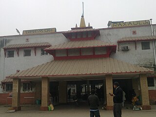
Raxaul is a sub-divisional town in the East Champaran district of the Indian state of Bihar. It is situated at the India-Nepal border with Birgunj city (Nepal). Raxaul is a major railway junction.
Nanpara is a town & municipal board in Bahraich district in the Indian state of Uttar Pradesh. It is a region along the Nepal Border and includes tracts of dense forests. It is a city surrounded by many villages.
Palia Kalan is a city and a municipal board, near Lakhimpur city in Lakhimpur Kheri district in the Indian State of Uttar Pradesh.

Lakhimpur is a city and a municipal board in the Lakhimpur Kheri district of the Indian state of Uttar Pradesh.
Koilabas is a bazaar town situated in Gadhawa Rural Municipality in Dang Deokhuri District in Lumbini Province of south-western Nepal. The town is situated on the southern edge of the Dudhwa Range of the Siwaliks, at Nepal's border with Uttar Pradesh 5 km from the village Jarwa on the other side. Indian and Nepalese nationals may cross the border unrestricted however there is a customs checkpoint for goods. Koilabas has regular bus service to Tulsipur on the Gorakhpur-Gonda Loop of Indian Railways.

The Sharda River is the downstream of Kali River that originates in the northern Uttarakhand state of India in the Great Himalayas on the eastern slopes of Nanda Devi massif, at an elevation of 3,600 m (11,800 ft) in the Pithoragarh district. It then flows between the Nepal and India border. Descending, it enters the Indo-Gangetic Plain at Brahmadev Mandi in Nepal, where it expands above the Sharda Barrage. From that point onward, it is known as the Sharda River. The river proceeds southeastward into India through northern Uttar Pradesh before merging with the Ghaghara River southwest of Bahraich, covering a distance of approximately 300 miles.
Basahi Banzar is a village situated in the Lakhimpur Kheri District, Uttar Pradesh, India, near the border with Nepal. One part is covered by forest and all the three part is covered agricultural farms. The river Shardha is nearby, as are the towns Basahi and Sampurna Nagar. The nearest railway station is Palia Kalanpalia kalan. People of this region generally do farming. Fair is also a popular event here which takes place every year. It is to celebrate harvesting festival and it is celebrate during Diwali. Most of the people are migrating for search of work to suburban and urban areas places like Bombay Punjab and few other places.

The Haldibari–New Jalpaiguri line connecting Haldibari in Cooch Behar district and New Jalpaiguri in Jalpaiguri district in the Indian state of West Bengal, was since 1878 a part of the Kolkata–Siliguri broad-gauge route. With the partition of India in 1947, while the main part of the route lay in East Pakistan, later Bangladesh, the two ends of the route lying in India were detached.. However, the route continued to be operational till the Indo-Pakistani War of 1965. Thereafter, the route had been closed till its reopening in 2020. The rest of the line had been in use in the respective countries.
The Barauni–Katihar, Saharsa and Purnia sections of the Barauni–Guwahati line connects Barauni, Saharsa, Purnia and Katihar in the Indian state of Bihar.
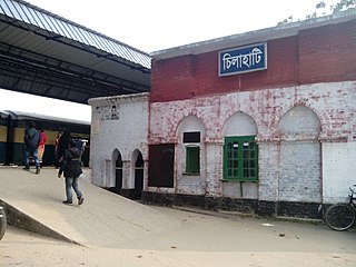
Chilahati is a border railway station in Bangladesh, situated in Nilphamari District, in Rangpur Division. It is an active railway transit point on the Bangladesh-India border.

The Barauni–Gorakhpur, Raxaul and Jainagar lines are a set of three lines connecting Barauni in the Indian state of Bihar with Gorakhpur in Uttar Pradesh. The lines run in an east–west direction between the Ganges and India-Nepal border, covering northern Bihar west of the Kosi river and eastern Uttar Pradesh. The southernmost of the lines connects via Hajipur Junction, Sonpur Junction,Chhapra and Siwan Junction. The central line connects via Muzaffarpur, Motihari and Sugauli. The northern line connects via Darbhanga, Sitamarhi and Raxaul. The lines have interconnections between them and the northern line has extensions to places near the India–Nepal border.
The Narkatiaganj–Bhikhna Thori line is a rail line in eastern India that connects Narkatiaganj and Bhikhna Thori near the Indo-Nepal border.
Laukaha Bazar railway station serves Laukaha town in Madhubani district in the Indian state of Bihar. It located near the India–Nepal border.
Haldibari Railway Station serves Haldibari town in Cooch Behar district of the Indian state of West Bengal. It is an active railway transit point on the Bangladesh–India border. Important trains like New Jalpaiguri-Dhaka Cantonment-New Jalpaiguri Mitali Express runs through Haldibari and Kolkata-Haldibari-Kolkata Tri-Weekly Intercity Express, Sealdah-Haldibari-Sealdah Darjeeling Mail originate and terminate at Haldibari Railway Station.

Rohilkund and Kumaon Railway (R&KR) was a metre gauge railway in India covering a total network of 592 miles (953 km). It was owned and worked by the Rohilkund and Kumaon Railway Company. The Rohilkund and Kumaon Railway was transferred to the Government of India and merged into the Oudh and Tirhut Railway on 1 January 1943.
The Muzaffarpur–Gorakhpur line is a set of three lines connecting Muzaffarpur in the Indian state of Bihar with Gorakhpur in Uttar Pradesh. The lines run in an east–west direction between the Gandak and India–Nepal border, covering North Bihar west of the Kosi river and eastern Uttar Pradesh. The southernmost of the three lines connects via Hajipur Junction, Sonpur Junction and Chhapra. The central line connects via Motihari and Sugauli. The northern line connects via Sitamarhi and Raxaul. The lines have interconnections between them and the northern line has extensions to places near the India–Nepal border.
The Barsoi–Radhikapur branch line links Barsoi railway station on the Howrah–New Jalpaiguri line to Radhikapur railway station on the Bangladesh–India border.
Bahraich railway station is a main railway station in Bahraich district, Uttar Pradesh, India. Its code is BRK. It serves the city of Bahraich.
Old Malda–Abdulpur line was built in 1930 during the British Indian rule. At present, the Bangladesh part of the railway line is operated and maintained under Bangladesh Railway and the Indian part of the railway line is managed and maintained by Indian Railways.

