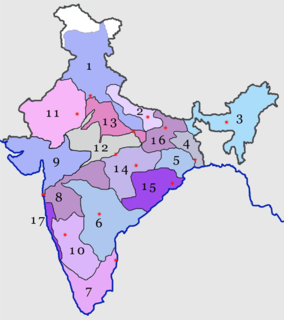
The North Eastern Railway is one of the 18 railway zones in India. It is headquartered at Gorakhpur and comprises three divisions-
- Izzatnagar railway division
- Lucknow NER railway division
- Varanasi City railway station Division.

Pilibhit is a city and a municipal board in the Pilibhit district in the Indian state of Uttar Pradesh. Pilibhit is the north-easternmost district of Bareilly division, situated in the Rohilkhand region of the sub-Himalayan Plateau belt next to foothills of Sivalik Range on the boundary of Nepal, known for the origin of river Gomati and one of the most forest-rich areas in North India. Pilibhit was also known as Bansuri Nagari – the land of flutes, for making and exporting roughly 95 per cent of India's flutes.

Lakhimpur Kheri district is the largest district in Uttar Pradesh, India, on the border with Nepal. Its administrative capital is the city of Lakhimpur.

Palia Kalan is a city and a municipal board in Lakhimpur Kheri district Uttar Pradesh.

Singahi Bhedaura is a town and a nagar panchayat in Lakhimpur Kheri district in the state of Uttar Pradesh, India.

Lakhimpur is a city and a municipal board in Lakhimpur Kheri district in the Indian state of Uttar Pradesh.
Kheri Lok Sabha constituency is one of the 80 Lok Sabha (parliamentary) constituencies in the Indian state of Uttar Pradesh.
Basahi Banzar is a village which is situated in the Lakhimpur Kheri District, Uttar Pradesh, India, near the border with Nepal. One part is covered by forest and all the three part is covered agricultural farms. The river Shardha is nearby, as are the towns Basahi and Sampurna Nagar Kheri. The nearest railway station is Palia Kalanpalia kalan. People of this region generally do farming. Fair is also a popular event here which takes place every year. It is to celebrate harvesting festival and it is celebrate during Diwali. Most of the people are migrating for search of work to suburban and urban areas places like Bombay Punjab and few other places.
Bhira Kheri is a small town located in the Lakhimpur Kheri district of Lucknow division, in the Uttar Pradesh state of India. It is situated 35 km away from the Indo-Nepal border.

Palia Airstrip is an airstrip situated near Dudhwa National Park at Palia Kalan in Lakhimpur Kheri District in the Indian state of Uttar Pradesh, 90 km from Lakhimpur City. It is only used by private jets.

Tikunia is a nagar panchayat in Lakhimpur Kheri district in the Indian state of Uttar Pradesh.
Uttar Pradesh State Highway 21 passes through Bilaraya - Lakhimpur - Sitapur - Panwari and covers a distance of 385.46 km.
Uttar Pradesh State Highway 25 starts from Palia (Lakhimpur) and goes to Lucknow and covers a distance of 265.50 km.
Uttar Pradesh State Highway 26 passes through Pilibhit - Lakhimpur - Bahraich - Basti and covers a distance of 402.03 km.
Uttar Pradesh State Highway 93 starts from Gola (Lakhimpur) and goes to Shahjanhapur and covers a distance of 58.62 km.

Lakhimpur Kheri district is further divided in following sub categories:
Ajay Kumar Mishra is an Indian politician and a member of Member of Parliament in the 16th Lok Sabha of India. He represents the Kheri constituency of Uttar Pradesh and is a member of the Bharatiya Janata Party political party.
Nighasan Assembly constituency is one of the 403 constituencies of the Uttar Pradesh Legislative Assembly, India. It is a part of the Lakhimpur Kheri district and one of the five assembly constituencies in the Kheri. First election in this assembly constituency was held in 1957 after the "DPACO (1956)" was passed in 1956. After the "Delimitation of Parliamentary and Assembly Constituencies Order" was passed in 2008, the constituency was assigned identification number 138.

Mailani railway station is a small Indian railway station in Lakhimpur Kheri district, Uttar Pradesh. Its code is MLN. It serves Mailani. The station has three platforms. The platforms are not well sheltered and lack many facilities, including water and sanitation.

Dudhwa railway station is a small railway station in Lakhimpur Kheri district, Uttar Pradesh. Its code is DDW. It is located in Dudhwa National Park, near Dudhwa village and Palia Kalan town. The station consists of one platform. The platform is not well sheltered. It lacks many facilities including water and sanitation.


