
The Arctic Archipelago, also known as the Canadian Arctic Archipelago, is an archipelago lying to the north of the Canadian continental mainland, excluding Greenland and Iceland.

James Ross Island is a large island off the southeast side and near the northeastern extremity of the Antarctic Peninsula, from which it is separated by Prince Gustav Channel. Rising to 1,630 metres (5,350 ft), it is irregularly shaped and extends 64 km in a north–south direction. It was charted in October 1903 by the Swedish Antarctic Expedition under Otto Nordenskiöld, who named it for Sir James Clark Ross, the leader of a British expedition to this area in 1842 that discovered and roughly charted a number of points along the eastern side of the island. The style, "James" Ross Island is used to avoid confusion with the more widely known Ross Island in McMurdo Sound.

Conchagua is a municipality in the La Unión department of El Salvador. It contains the Conchagua volcano. The proposed Airport of the Pacific will be built in the municipality.
Serra Negra is a small mountain range on the border of Brazilian states Sergipe and Bahia. Its highest elevation is 742 m. The nearest town is Pedro Alexandre.
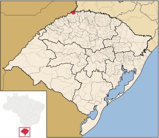
Derrubadas is a municipality of the Brazilian state of Rio Grande do Sul.
Barrio Obrero is a barrio (neighbourhood) of Asunción, the capital of Paraguay. It has a population of 19,823 people. The name of this barrio comes from the word "worker" (obrero) in reference to the humble and working class people who form the majority of the population.

Micereces de Tera is a municipality located in the province of Zamora, Castile and León, Spain. According to the 2004 census (INE), the municipality has a population of 595 inhabitants.
El-Sayed Glacier is a glacier about 15 nautical miles long which drains the northeast slopes of Zuncich Hill in Marie Byrd Land. It flows northeast to enter Land Glacier at the south side of Mount Shirley. It was mapped by the United States Geological Survey from surveys and U.S. Navy air photos, 1959–65, and was named by the Advisory Committee on Antarctic Names for Sayed Z. El-Sayed, a United States Antarctic Research Program oceanographer on the International Weddell Sea Oceanographic Expeditions, 1967–68 and 1969–70.

Daule, is a canton located in the Guayas province in Ecuador. Created in 1820, it is one of the most important parts of Guayas thanks to its rice production and other products such as corn and eggs.
Taraco, La Paz is a town in the La Paz Department, Bolivia.
Rio Rufino is a municipality in the state of Santa Catarina in the South region of Brazil.

Nova Serrana is a municipality in the state of Minas Gerais in the Southeast region of Brazil.
Los Talas (Catamarca) is a village and municipality in Catamarca Province in northwestern Argentina.
Singuil is a village and municipality in Catamarca Province in northwestern Argentina.
La Sabana is a village and municipality in Chaco Province in northern Argentina.
Kolgu is a village in Kuusalu Parish, Harju County in northern Estonia. It lies on the Valgejõgi River, just northwest of the town of Tapa.
Jantra is a village in Võru Parish, Võru County in southeastern Estonia.