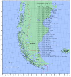
Chilean Baseline, an example of straight baseline use
The following methods are used to measure a baseline under the Law of the Sea Convention. In all cases, the baseline is drawn according to the state's own charts.[1]
Normal baseline
In most cases, the baseline follows the low-water line of the coastal state. There are a variety of special rules and exceptions for a range of geological features, including bays, ports, rocks, artificial structures and reefs.[2][1]
Straight baselines
The UN Convention allows for straight baselines to be drawn where deeply indented coastline and fringes of islands are closely connected to the coastline. Straight baselines must be drawn between the features and the coastline, in the general direction of the coast, and cannot be drawn across low-tide elevations. The Convention also prohibits straight baselines that would cut off another state's access to territorial sea or Exclusive Economic Zone. Since their introduction, countries including Canada and China have used straight baselines to extend their maritime borders.[1]
This page is based on this Wikipedia article Text is available under the CC BY-SA 4.0 license; additional terms may apply. Images, videos and audio are available under their respective licenses.