
Buffalo Bayou is a slow moving body of water which flows through Houston in Harris County, Texas. Formed 18,000 years ago, it has its source in the prairie surrounding Katy, Fort Bend County, and flows approximately 53 miles (85 km) east through the Houston Ship Channel into Galveston Bay and the Gulf of Mexico. In addition to drainage water impounded and released by the Addicks and Barker reservoirs, the bayou is fed by natural springs, surface runoff, and several significant tributary bayous, including White Oak Bayou, Greens Bayou, and Brays Bayou. Additionally, Buffalo Bayou is considered a tidal river downstream of a point 440 yards (400 m) west of the Shepherd Drive bridge in west-central Houston.

The Houston Ship Channel, in Houston, Texas, is part of the Port of Houston, one of the busiest seaports in the world. The channel is the conduit for ocean-going vessels between Houston-area terminals and the Gulf of Mexico, and it serves an increasing volume of inland barge traffic.

The Atchafalaya Basin, or Atchafalaya Swamp, is the largest wetland and swamp in the United States. Located in south central Louisiana, it is a combination of wetlands and river delta area where the Atchafalaya River and the Gulf of Mexico converge. The river stretches from near Simmesport in the north through parts of eight parishes to the Morgan City southern area.

The Little Manatee River flows 51 miles (82 km), from east of Fort Lonesome, Florida South of Hwy 674 and Earl Reynolds Rd In Hillsborough County through southern Hillsborough County, Florida including towns such as Sun City, Florida, and Gulf City, Florida and northern Manatee County, Florida into Tampa Bay. It has a drainage basin of 222 square miles (570 km2). It flows along the Little Manatee River State Park for part of its route. Portions of the river Such as Hayes Bayou and Mills Bayou have been designated as an Outstanding Florida Water and are part of the Cockroach Bay Aquatic Preserve.

Allen's Landing is the officially recognized birthplace of the city of Houston, Texas, United States, the largest city in Texas and the fourth largest in the United States. Located in Downtown Houston between the Main Street and Fannin Street viaducts, the landing encompasses the southern bank of Buffalo Bayou, the city's principal river, at its confluence with White Oak Bayou, a major tributary. Allen's Landing is located south of the University of Houston–Downtown Commerce Street Building.
White Oak Bayou is a slow-moving river in Houston, Texas. A major tributary of the city's principal waterway, Buffalo Bayou, White Oak originates near the intersection of Texas State Highway 6 and U.S. Highway 290 and meanders southeast for 25 miles (40 km) until it joins Buffalo Bayou in Downtown. The river serves as a greenway which connects Downtown to the Houston Heights, Oak Forest, Garden Oaks, and Inwood Forest.
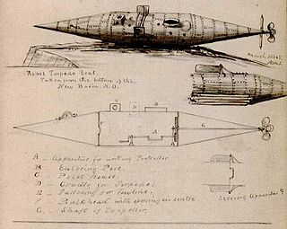
Pioneer was the first of three submarines privately developed and paid for by Horace Lawson Hunley, James McClintock, and Baxter Watson.

Bayou Plaquemine Brulé is a waterway in the Mermentau River basin of south Louisiana. The bayou is 58 miles (93 km) long and is navigable for 19 miles (31 km) of its lower course.

Choctawhatchee Bay is a bay in the Emerald Coast region of the Florida Panhandle. The bay, located within Okaloosa and Walton counties, has a surface area of 334 square kilometres (129 sq mi). It is an inlet of the Gulf of Mexico, connected to it through East Pass. It also connects to Santa Rosa Sound in Fort Walton Beach, Florida to the west and to St. Andrews Bay in Bay County to the east, via the Gulf Intracoastal Waterway. East Pass is the only outlet of the bay flowing directly into the Gulf of Mexico. The Choctawhatchee River flows into Choctawhatchee Bay, as do several smaller rivers and streams. The Mid-Bay Bridge crosses the bay, connecting the city of Destin to Niceville, Florida.

The Atchafalaya National Wildlife Refuge is located about 30 miles (48 km) west of Baton Rouge, Louisiana, and one mile (1.6 km) east of Krotz Springs, Louisiana, lies just east of the Atchafalaya River. In 1988 under the administration of Governor Foster the "Atchafalaya Basin Master Plan" was implemented that combined the 11,780-acre (4,770 ha) Sherburne Wildlife Management Area (WMA), the 15,220-acre (6,160 ha) Atchafalaya National Wildlife Refuge, and the 17,000-acre (6,900 ha) U.S. Army Corps of Engineers' Bayou Des Ourses into the Sherburne Complex Wildlife Management Area.
D'Arbonne National Wildlife Refuge is a National Wildlife Refuge of the United States located north of West Monroe, Louisiana. It is in Ouachita and Union Parishes on either side of Bayou D'Arbonne near its confluence with the Ouachita River. It lies on the western edge of the Mississippi River alluvial valley. It was established in 1975 to protect bottomland hardwoods and provide wintering habitat for migratory waterfowl. D'Arbonne is one of four refuges managed in the North Louisiana Refuges Complex.

Caney Creek is a river in Texas that begins northwest of Wharton, flows generally southeast, and empties into the Gulf of Mexico near Sargent. The major waterway to the west is the Colorado River while the next major waterway to the east is the San Bernard River.

The Barbours Cut Container Terminal, or simply the Barbours Cut Terminal, is a major deep water port in the Greater Houston area in the U.S. state of Texas. It is part of one of the world's busiest ports by cargo tonnage.
The Sherburne Complex is a joint land management venture of the U.S. Fish and Wildlife Service, the Louisiana Department of Wildlife and Fisheries (LDWF), and the U.S. Army Corps of Engineers that began in 1983. The area consists of 44,000 acres (180 km2), and is managed by the Louisiana Department of Wildlife and Fisheries. The complex is located in the Morganza Flood way system of the Atchafalaya Basin about 30 miles (48 km) west of Baton Rouge, Louisiana and actually extends a little south of the I-10 Atchafalaya Basin Bridge at Whiskey Bay, Louisiana. The bridge crosses the Whiskey Bay Pilot Channel. Located on the graveled LA 975, the west boundary is on the east side of the Atchafalaya River with the east boundary being the East Protection Levee. The complex stretches just north of old highway 190, and a short distance to the south of I-10. The nearest town is Krotz Springs to the north off US 190.
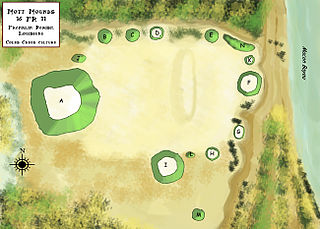
The Mott Archaeological Preserve or Mott Mounds Site is an archaeological site in Franklin Parish, Louisiana on the west bank of Bayou Macon. It originally had eleven mounds with components from the Marksville, Troyville, Coles Creek, and Plaquemine periods. It was at one time one of the largest mound centers in the Southeast and has one of the largest mounds in Louisiana with a base which cover more than two acres. It was purchased by the Archaeological Conservancy in 2002. and is now used for research and educational purposes.

The Roland Site is an archaeological site located on Dry Lake, an extinct channel of the White River in Arkansas County, Arkansas. It was inhabited intermittently from the beginning of the common era to late prehistoric times, but its most intensive inhabitation was by peoples of the Plum Bayou culture, in a time known as the Late Woodland period.

Brays Bayou is a slow-moving river in Harris County, Texas. A major tributary of Buffalo Bayou, the Brays flows for 31 miles (50 km) from the western edge of the county, south of Barker Reservoir along the border with Fort Bend County, east to its convergence with the Buffalo at Harrisburg. Nearly all of the river is located within the city of Houston; it is a defining geographic feature of many neighborhoods and districts, including Meyerland, Braeswood Place, the Texas Medical Center, and Riverside Terrace.

The Atchafalaya Basin Mounds is an archaeological site originally occupied by peoples of the Coastal Coles Creek and Plaquemine cultures beginning around 980 CE, and by their presumed historic period descendants, the Chitimacha, during the 18th century. It is located in St. Mary Parish, Louisiana on the northern bank of Bayou Teche at its confluence with the Lower Atchafalaya River. It consists of several earthen platform mounds and a shell midden situated around a central plaza. The site was visited by Clarence Bloomfield Moore in 1913.
