
Orion Charter Township is a charter township of Oakland County, Michigan, United States. The population was 38,206 as of the 2020 census.

The American Discovery Trail is a system of recreational trails and roads that collectively form a coast-to-coast hiking and biking trail across the mid-tier of the United States. Horses can also be ridden on most of this trail. The coastal trailheads are the Delmarva Peninsula on the Atlantic Ocean and the northern California coast on the Pacific Ocean. The trail has northern and southern alternates for part of its distance, passing through Chicago and St. Louis respectively. The total length of the trail, including both the north and south routes, is 6,800 miles (10,900 km). The northern route covers 4,834 miles (7,780 km) with the southern route covering 5,057 miles (8,138 km). It is the only non-motorized coast-to-coast trail.

The Sepulveda Dam is a dry dam constructed by the U.S. Army Corps of Engineers to withhold winter flood waters along the Los Angeles River. Completed in 1941, at a cost of $6,650,561, it is located south of center in the San Fernando Valley, approximately eight miles (13 km) east of the river's source in the western end of the Valley, in Los Angeles, California.

The main segment of the Los Gatos Creek Trail is a 9.7-mile (15.6 km) pedestrian and bicycle trail that runs through western Santa Clara County in California. It runs from Lexington Reservoir in Los Gatos, California through Campbell, California to Meridian Avenue in San Jose, California alongside Los Gatos Creek.

Blue Knob State Park is a 6,128-acre (2,480 ha) Pennsylvania state park in Kimmel, Lincoln, and Pavia townships in Bedford County, Pennsylvania, in the United States. The average annual snowfall at the park is about 12 feet (370 cm). The park is named for Blue Knob, the second highest mountain in Pennsylvania at 3,146 feet (959 m). It is the location of Blue Knob All Seasons Resort, the ski slope in Pennsylvania with the highest elevation. Blue Knob State Park is just off Interstate 99 on Pennsylvania Route 869 west of Pavia.
Summit Metro Parks is a Metroparks system serving the citizens of Summit County, Ohio by managing 14,000 acres (5,700 ha) in 16 developed parks, six conservation areas and more than 150 miles (240 km) of trails, with 22.4 miles (36.0 km) of the Ohio & Erie Canal Towpath Trail.

Hatcher Pass is a mountain pass through the southwest part of the Talkeetna Mountains, Alaska. It is named after Robert Hatcher, a prospector and miner. The nearest cities are Palmer and Wasilla approximately 12 miles (19 km) to the south, and Willow approximately 26 mi (42 km) to the west. The communities are at an elevation of approximately 250 ft (76 m) in the Mat-Su valley.

Blue Hills Reservation is a 7,000-acre (2,800 ha) state park in Norfolk County, Massachusetts in the United States. Managed by the Massachusetts Department of Conservation and Recreation, it covers parts of Milton, Quincy, Braintree, Canton, Randolph, and Dedham. Located approximately ten miles south of downtown Boston, the reservation is one of the largest parcels of undeveloped conservation land within the Greater Boston metropolitan area. The park's varied terrain and scenic views make it a popular destination for hikers from the Boston area.

Sylvania Tam-O-Shanter and the Sylvania Sports and Exhibition Center are a combined, multi-purpose athletics complex and convention center located in Sylvania, Ohio. The original Tam-O-Shanter complex consisted of a single ice rink built in 1972, was expanded upon in 1993 and 2001, and as of 2019 is operated by the Sylvania Joint Area Recreational District.

Three Rivers Park District is a special park district serving the suburban areas of the Twin Cities including suburban Hennepin, Carver, Dakota, Scott, and Ramsey counties. Three Rivers's mission is "To promote environmental stewardship through recreation and education in a natural resources-based park system." Three Rivers operates twenty parks and ten regional trails, with at least two more regional trails planned. Nearly seven million people visit Three Rivers facilities each year. It has over 27,000 acres (11,000 ha) of parks and trails.

Huntington is home to eleven parks located in the neighborhoods of Huntington. An amusement park is also adjacent to the city.
Columbia Cosmopolitan Recreation Area, commonly referred to as Cosmo Park, is a city park in Columbia, Missouri. At 533 acres (2.16 km2), it is the largest park in Columbia. It is also the location of the annual Show-Me State Games.

Pinckney State Recreation Area is a Michigan state recreation area in Dexter, Sylvan and Lyndon Townships, Washtenaw County and Putnam and Unadilla Townships, Livingston County in the U.S. state of Michigan. The park is 11,000 acres (4,500 ha) and sits at an elevation of 922 feet (281 m). The park is connected to the nearby Waterloo State Recreation Area by the 35-mile (56 km) Waterloo–Pinckney Trail. Pinckney State Recreation Area is open for year-round recreation including hiking, fishing, swimming, hunting and a variety of winter sports.

The Snyderville Basin is a valley in Summit County, Utah adjacent to Park City. Many of the residents of the Park City area live in the Snyderville Basin. Though the area lies outside of the Park City limits, and receives many services from Summit County instead of Park City, it is part of the Park City School District. Major landmarks within the Snyderville basin include Canyons Village at Park City, Utah Olympic Park, Swaner EcoCenter, the Basin Recreation Fieldhouse and the Kimball Junction commercial centers.
Allandale, Austin, Texas is a neighborhood in North Central Austin, in the U.S. State of Texas known for its large lots, mature trees, and central location.
Reedy Creek Park is a 125-acre (51 ha) urban park at 2900 Rocky River Road in the Newell section of Charlotte, North Carolina. Adjacent to the park is a 737 acre nature preserve.
Willamalane Park and Recreation District maintains and operates five recreation facilities and 46 parks and natural areas, totaling more than 1,500 acres. Highlights include 10 waterfront areas, 29 miles of hiking and biking trails, 9 sports fields and 27 playgrounds. Willamalane offers hundreds of recreation programs to more than 60,000 patrons. Created by voters in 1944, Willamalane is a special tax district, separate from the city of Springfield, Oregon, with its own boundaries. It is governed by a five-member, elected board of directors and managed by a district superintendent. Willamalane offers:
Oxon Run Park is a recreational park in Southeast Washington, D.C., that features sports areas, trails, playgrounds and the Southeast Tennis and Learning Center. The park was created in 1971 from land that was previously part of the federally-controlled Oxon Run Parkway.

Minneapolis is often considered one of the top biking and walking cities in the United States due to its vast network of trails and dedicated pedestrian areas. In 2020, Walk Score rated Minneapolis as 13th highest among cities over 200,000 people. Some bicycling ratings list Minneapolis at the top of all United States cities, while others list Minneapolis in the top ten. There are over 80 miles (130 km) of paved, protected pathways in Minneapolis for use as transportation and recreation. The city's Grand Rounds National Scenic Byway parkway system accounts for the vast majority of the city's shared-use paths at approximately 50 miles (80 km) of dedicated biking and walking areas. By 2008, other city, county, and park board areas accounted for approximately 30 miles (48 km) of additional trails, for a city-wide total of approximately 80 miles (130 km) of protected pathways. The network of shared biking and walking paths continued to grow into the late 2010s with the additions of the Hiawatha LRT Trail gap remediation, Min Hi Line pilot projects, and Samatar Crossing. The city also features several natural-surface hiking trails, mountain-biking paths, groomed cross-country ski trails in winter, and other pedestrian walkways.
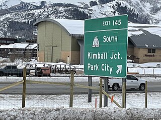
Kimball Junction is a settlement located in Snyderville, Utah. At the 2020 US census, the population was 6,744 people. Named after William Henry Kimball and the site of the former Kimball Stage Stop, the area now serves as a gateway to Park City via State Route 224. Kimball Junction is home to the Redstone and Newpark Districts, with both servicing hotels and restaurants, and the Kimball Junction Transit Center, which provides connections to Park City.

