
Wasatch County is a county in the U.S. state of Utah. As of the 2020 United States Census, the population was 34,788. Its county seat and largest city is Heber City. The county was named for a Ute word meaning "mountain pass" or "low place in the high mountains".

Park City is a city in Utah, United States. The vast majority is in Summit County with some portions extending into Wasatch County. It is considered to be part of the Wasatch Back. The city is 32 miles (51 km) southeast of downtown Salt Lake City and 20 miles (32 km) from Salt Lake City's east edge of Sugar House along Interstate 80. The population was 8,396 at the 2020 census. On average, the tourist population greatly exceeds the number of permanent residents.

This is the Place Heritage Park is a Utah State Park that is located on the east side of Salt Lake City, Utah, United States, at the foot of the Wasatch Range and near the mouth of Emigration Canyon. A non-profit foundation manages the park.

Capitol Hill in Salt Lake City gets its name from the Utah State Capitol prominently overlooking downtown. In addition, Capitol Hill can be considered a neighborhood of Salt Lake City.

Parleys Canyon is a canyon located in the U.S. state of Utah. The canyon provides the route of Interstate 80 (I-80) up the western slope of the Wasatch Mountains and is a relatively wide, straight canyon other than near its mouth. The mountain pass at the top of the canyon is known as Parleys Summit. With an elevation of 7,120 feet (2,170 m), the pass is the highest point along I-80 in the state of Utah. Both features are named for Parley P. Pratt, an early settler of the Salt Lake Valley and leader of the Church of Jesus Christ of Latter-day Saints who surveyed the area to find a better transportation route through the Wasatch Mountains than the previous route which traversed Emigration Canyon.
The Wasatch Back is a region in the Rocky Mountains in the U.S. state of Utah. It includes cities such as Park City, Heber City, and Morgan. The name Wasatch Back differentiates it from the Wasatch Front, which includes Utah's more populous cities such as Salt Lake City, Ogden, Layton, and Provo. The Wasatch Back sits on the eastern side of the Wasatch Range of the Rocky Mountains, while the Wasatch Front sits on the western side. Wasatch is a Ute Indian word that means "mountain pass" or "low pass over high range." The Wasatch Back is a very affluent region. Summit County is one of the wealthiest counties in the United States.

The west end of U.S. Route 40 (US-40) is in the U.S. state of Utah at Silver Creek Junction in Silver Summit with Interstate 80. From there it heads southeast through Heber City and east into Colorado on its way to the Mid-Atlantic.

The Dinosaur Diamond is a 486-mile (782 km) scenic and historic byway loop through the dinosaur fossil laden Uinta Basin of the U.S. states of Utah and Colorado. The byway comprises the following two National Scenic Byways:

State Route 224 (SR-224) is a north–south state highway in the U.S. state of Utah. The route connects Interstate 80 and Kimball Junction in the north to Park City in the south. Ski resorts line the mostly four-lane highway, including Park City Resort and Deer Valley. The highway has changed paths many times since its formation in 1941, at one point connecting to Big Cottonwood Canyon and Salt Lake County. However, realignments brought the route to its present path by 1990.
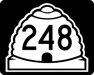
State Route 248 is a highway in northern Utah that connects Park City with Kamas. In Park City it is known as Kearns Boulevard.
Millcreek Canyon is a canyon in the Wasatch Mountains and part of Millcreek City on the east side of the Salt Lake Valley, Utah. It is a popular recreation area both in the summer and in the winter. It was named by Brigham Young on August 22, 1847, before all of the mills that were built in and below the densely forested canyon. It is home to two restaurants and six Boy Scout Day Camps.

The Kimball-Whitney Cemetery is a cemetery in Salt Lake City, Utah. United States. It is where the remains of fifty-six persons related to Heber C. Kimball and Newel K. Whitney are interred. Set aside in 1848, it is one of the first formally dedicated burial grounds within the Salt Lake Valley.

Park City Transit is a public transit agency that serves Park City, Utah. It provides fare-free service and operates 12 routes. The transit district has been operating since 1975 and has won awards from the American Public Transit Association and Utah's Best of State in 2023. Park City Transit primarily operates fixed-bus service, and partners with High Valley Transit to deliver microtransit in Park City.
East Basin is an unincorporated area and census-designated place (CDP) in Summit County, Utah, United States. It was first listed as a CDP prior to the 2020 census.
McLeod Creek is a 9.0-mile-long (14.5 km) northwards-flowing stream that begins 1.3 miles (2.1 km) southwest of Park City, Utah on the east side of the summit of the Wasatch Range. It is one of the upper reaches of the East Canyon Creek watershed in Summit County, Utah, which flows to the Weber River ad ultimately the Great Salt Lake.
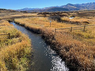
Silver Creek is a 19.3-mile-long (31.1 km) north by northeastwards-flowing stream that begins 1.3 miles (2.1 km) southwest of Park City, Utah on Bald Eagle Mountain east of the Wasatch Range summit. It is a tributary of the upper Weber River in Summit County, Utah, which ultimately flows to the Great Salt Lake.
High Valley Transit is a transit agency located in the Summit and Wasatch counties of Utah. It operates throughout many different municipalities in the Wasatch Back, including Park City, Kamas, and Heber and provides fare-free service. The authority also provides a connection to the Salt Lake Valley via its 107 route. It operates fixed-route bus services and the region's first micro transit service, relying on an app to schedule bookings. High Valley Transit was created in 2021, after parts of Park City Transit were deemed largely inefficient in serving the greater Park City Area.
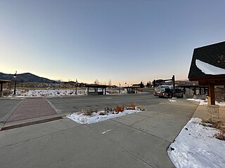
The Kimball Junction Transit Center is a transit hub located in Kimball Junction, Utah. It serves two transit agencies: Park City Transit and High Valley Transit, both of which provide fare-free service. Both transit agencies provide access to Park City, while High Valley Transit provides access to the Salt Lake Valley via its 107 route.
Basin Recreation is a Recreation District in Summit County, Utah. Established in 1986 by the Summit County Board of Commissioners, the district manages roughly 170 miles of trails, over 2300 acres of open space and four parks.
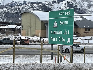
Kimball Junction is a settlement located in Snyderville, Utah. At the 2020 US census, the population was 6,744 people. Named after William Henry Kimball, and the site of the former Kimball Stage Stop, the area now serves as a gateway to Park City via State Route 224. Kimball Junction is home to the Redstone and Newpark Districts, with both servicing hotels and restaurants, the Kimball Junction Transit Center, which provides connections to Park City, and various neighborhoods.
