
Feni is a coastal district situated in the south-east of Bangladesh, within the Chittagong Division. One of Bangladesh's smallest districts, it is strategically located along the Dhaka–Chittagong transportation corridor. Bordered by India to the north and the Bay of Bengal to the south, it serves as the sole entry point linking Chittagong, the country's primary port city, to the northern districts.
Tangail is a district (zila) in the central region of Bangladesh. In 1969, Tangail district was created by Tangail Mohokuma from its 237 square kilometers of land and 3177 square kilometers of land acquired from Mymensingh district. It is the largest district of Dhaka division by area and second largest by population. The population of Tangail zila is about 4 million and its area is 3,414.28 square kilometres (1,318.26 sq mi). The main city of the district is Tangail. It is surrounded by Jamalpur District on the north, the Dhaka and Manikganj Districts on the south, Mymensingh and Gazipur on the east, and Sirajganj on the west.

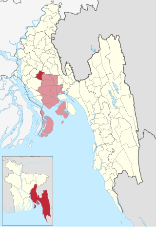
Noakhali, historically known as Bhulua, is a district in southeastern Bangladesh, located in the Chittagong Division. It was established as a district in 1821, and officially named Noakhali in 1868. The district's administrative center is situated in the municipality of Noakhali, also referred to as Maijdee, within Noakhali Sadar Upazila. Notably, Noakhali is the only district in Bangladesh that does not have a city named after itself.

Manikganj is a district in central Bangladesh and part of the Dhaka Division. It was established in 1845, it was a subdivision of Faridpur District until, in 1953, it was transferred to Dhaka District for administrative purposes. In 1984, Manikganj was declared a full district.

Lakshmipur is a district in Bangladesh with an area of 1,440 km2. It is bordered by Chandpur to the north, Bhola and Noakhali districts to the south, Noakhali to the east, and Barisal and Bhola districts to the west. Lakshmipur was part of Noakhali until 15 February 1984, when the western part of Noakhali was reorganised from Lakshmipur subdivision into Lakshmipur district to improve administrative efficiency.

Begumganj is an upazila of the Noakhali District in Bangladesh's Chittagong Division. Begumganj Thana, now an upazila, was established in 1892.
Chatkhil is an upazila of Noakhali District in Chittagong Division, Bangladesh. Chatkhil thana was formed in 1977 and was upgraded into an upazila in 1983.

Companiganj is an upazila of Noakhali District. Basurhat is the only municipality in this upazila. The area is famed for water buffalo doi (curd).

Hatiya is an upazila (sub-district) of Noakhali District in Bangladesh's Chittagong Division. It encompasses several islands of Bangladesh, most notably Hatiya Island, Bhasan Char, Nijhum Dwip and Jahazir Char.
Senbagh, also spelt Senbag and Senbug, is an upazila of Noakhali District. It is named after its administrative centre, the municipality of Senbagh.

Noakhali Sadar is an upazila of Noakhali District in the Division of Chittagong, Bangladesh. Noakhali Thana was established in 1861 and was converted into an upazila in 1984. The upazila takes its name from the district and the Bengali word sadar (headquarters). It is the subdistrict where the district headquarters, Noakhali town, is located. The town is situated on the western bank of the Noakhali Canal, from which it takes its name. The Noakhali Canal was dug in 1660 to control flooding of the river Dakatia. The name Noakhali means "New canal", derived from the Bengali words noa (new) and khal (canal).
Companiganj is an upazila of Sylhet District in the Division of Sylhet, Bangladesh.
Companiganj is the name of two Upazilas in Bangladesh:

Sonaimuri (সোনাইমুড়ী) is a newly established upazila or sub-district in Noakhali District, Bangladesh. It consists of ten union councils or parishads - Ambarnagar, Amisha Para, Bazra, Deoti, Jayag, Nadana, Nateshwar, Sonaimuri, Sonapur and Baragaon. Sonaimuri was declared as an upazila in response to a popular demand in 2005. The area of Sonaimuri is 169.14 km2 while its population is 327,194. People in this upazila is generally solvent and engaged in business and agriculture.

Kabirhat is an upazila of the Noakhali District, located in Bangladesh's Chittagong Division. It is named after its administrative centre, the town of Kabirhat, and is the newest upazila of the district.

Obaidul Quader is a Bangladeshi politician who has been the General Secretary of Bangladesh Awami League since October 2016. He was the Minister of Road Transport and Bridges during 2011–2024 and represented the Noakhali-5 constituency as a Jatiya Sangsad member during 2009–2024. He is also the Media Adviser for the Bangladesh Awami League and regularly conducts press conferences on their behalf. Previously, he served as the State Minister for Youth and Sports between 1996 and 2001. In July and August 2024, widespread protests erupted against the Awami League government, which violently suppressed the demonstrations, resulting in the deaths of over a thousand people, the majority of whom were students and children. Awami League is directly responsible for these murders. Amid rising public outrage and demands for accountability for these atrocities, Quader has been reported missing since August 5, 2024.
Noakhali Government Girls' High School is a girls' school in Noakhali Sadar Upazila, Noakhali District, Bangladesh, established in 1934, founded by late Uma Devi, a school in Maijdee for the girls' education. It was upgraded to a government school in 1963. Now it is considered one of the prominent schools in the Noakhali district. Noakhali Government Girl's High School is situated in the center of Maijdee town.
Chowmuhani Government S.A College is a public college in Begumganj Upazila, Noakhali District, Bangladesh established in 1943. The college is affiliated with National University.
Shahadat Hossain Chowdhury(afwc, psc, te) is a retired Brigadier general of Bangladesh Army who also served as one of the Election Commissioners of Bangladesh during 2017-2022.

The Greater Noakhali region predominantly includes the districts of Noakhali, Feni and Lakshmipur in Bangladesh, though it has historically also included Bhola, Sandwip and some southern parts of Tripura in India and southern Comilla. The history of the Noakhali region begins with the existence of civilisation in the villages of Shilua and Bhulua. Bhulua became a focal point during the Buddhist and Hindu kingdoms of Pundra, Harikela and Samatata leading it to become the initial name of the region as a whole. The medieval Kingdom of Bhulua enjoyed autonomy under the Twipra Kingdom and Bengal Sultanate before being conquered by the Mughal Empire. At the beginning of the 17th century, Portuguese pirates led by Sebastian Gonzales took control of the ara but were later defeated by Governor Shaista Khan. Affected by floodwaters, the capital of the region was swiftly moved to a new place known as Noakhali, from which the region presently takes its name. By 1756, the British East India Company had dominated and started to establish several factories in the region. The headquarters was once again moved in 1951, to Maijdee, as a result of Noakhali town vanishing due to fluvial erosion.

