Related Research Articles

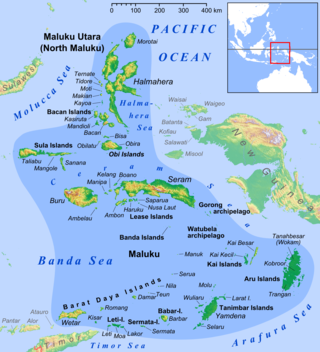
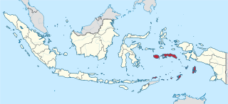
The Maluku Islands or the Moluccas are an archipelago in the eastern part of Indonesia. Tectonically they are located on the Halmahera Plate within the Molucca Sea Collision Zone. Geographically they are located east of Sulawesi, west of New Guinea, and north and east of Timor. Lying within Wallacea, the Moluccas have been considered a geographical and cultural intersection of Asia and Oceania.

The Bacan Islands, formerly also known as the Bachans, Bachians, and Batchians, are a group of islands in the Moluccas in Indonesia. They are mountainous and forested, lying south of Ternate and southwest of Halmahera. The islands are administered by the South Halmahera Regency of North Maluku Province. They formerly constituted the Sultanate of Bacan.

North Maluku is a province of Indonesia. It covers the northern part of the Maluku Islands, bordering the Pacific Ocean to the north, the Halmahera Sea to the east, the Molucca Sea to the west, and the Seram Sea to the south. It shares maritime borders with North Sulawesi, Southeast Sulawesi and Central Sulawesi to the west, Maluku to the south, Southwest Papua to the east, and Palau and the Philippines to the north. The provincial capital is Sofifi, mostly part of the city of Tidore Islands on the largest island of Halmahera, while the largest city is the island city of Ternate. The population of North Maluku was 1,038,087 in the 2010 census, making it one of the least-populous provinces in Indonesia, but by the 2020 Census the population had risen to 1,282,937, and the official estimate as at mid 2023 was 1,328,594.

Morotai Island Regency is a regency of North Maluku province, Indonesia, located on Morotai island. It covers an area of 2,336.6 km2 including the smaller Rao Island to the west of Morotai. The population was 52,860 at the 2010 census and 74,436 at the 2020 census; the official estimate as at mid 2023 was 80,566.

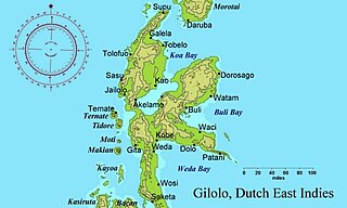
Halmahera, formerly known as Jilolo, Gilolo, or Jailolo, is the largest island in the Maluku Islands. It is part of the North Maluku province of Indonesia, and Sofifi, the capital of the province, is located on the west coast of the island.

Maluku is a province of Indonesia. It comprises the central and southern regions of the Maluku Islands. The largest city and capital of Maluku province is Ambon on the small Ambon Island. It is directly adjacent to North Maluku, Southwest Papua, and West Papua in the north, Central Sulawesi, and Southeast Sulawesi in the west, Banda Sea, Australia, East Timor and East Nusa Tenggara in the south and Arafura Sea, Central Papua and South Papua in the east. The land area is 57803.81 km2, and the total population of this province at the 2010 census was 1,533,506 people, rising to 1,848,923 at the 2020 census, the official estimate as at mid 2023 was 1,908,753. Maluku is located in Eastern Indonesia.

Ternate, also known as the City of Ternate, is the city with the largest population in the province of North Maluku and an island in the Maluku Islands, Indonesia. It was the de facto provincial capital of North Maluku before Sofifi on the nearby coast of Halmahera became the capital in 2010. It is off the west coast of Halmahera, and is composed of five islands: Ternate, the biggest and main island of the city, and Moti, Hiri, Tifure and Mayau. In total, the city has a land area of 162.20 square kilometres and had a total population of 185,705 according to the 2010 census, and 205,001 according to the 2020 census, with a density of 1,264 people per square kilometre; the official estimate as at mid 2023 was 204,920. It is the biggest and most densely populated city in the province, as well as the economic, cultural, and education center of North Maluku, and acts as a hub to neighbouring regions. It was the capital of the Sultanate of Ternate in the 15th and 16th centuries, and fought against the Sultanate of Tidore over control of the spice trade in the Moluccas before becoming a main interest to competing European powers.

Tidore is a city, island, and archipelago in the Maluku Islands of eastern Indonesia, west of the larger island of Halmahera. Part of North Maluku Province, the city includes the island of Tidore together with a large part of Halmahera Island to its east. In the pre-colonial era, the Sultanate of Tidore was a major regional political and economic power, and a fierce rival of nearby Ternate, just to the north. Within the city is the provincial capital, Sofifi.

The Obi Islands are a group of 42 islands in the Indonesian province of North Maluku, north of Buru and Ceram, and south of Halmahera. With a total area of 3,048.08 km2, they had a population of 41,455 at the 2010 Census and 50,760 at the 2020 Census. The official estimate as at mid 2023 was 53,182.

The Sultanate of Ternate, previously also known as the Kingdom of Gapi is one of the oldest Muslim kingdoms in Indonesia besides the sultanates of Tidore, Jailolo, and Bacan.

The Sultanate of Tidore was a sultanate in Southeast Asia, centered on Tidore in the Maluku Islands. It was also known as Duko, its ruler carrying the title Kië ma-kolano. Tidore was a rival of the Sultanate of Ternate for control of the spice trade and had an important historical role as binding the archipelagic civilizations of Indonesia to the Papuan world. According to extant historical records, in particular the genealogies of the kings of Ternate and Tidore, the inaugural Tidorese king was Sahjati or Muhammad Naqil whose enthronement is dated 1081 in local tradition. However, the accuracy of the tradition that Tidore emerged as a polity as early as the 11th century is considered debatable. Islam was only made the official state religion in the late 15th century through the ninth King of Tidore, Sultan Jamaluddin. He was influenced by the preachings of Syekh Mansur, originally from Arabia. In the 16th and 17th centuries, the Sultans tended to ally with either Spain or Portugal to maintain their political role but were finally drawn into the Dutch sphere of power in 1663. Despite a period of anti-colonial rebellion in 1780–1810, the Dutch grip on the sultanate increased until decolonization in the 1940s. Meanwhile, Tidore's suzerainty over Raja Ampat and western Papua was acknowledged by the colonial state. In modern times, the sultanate has been revived as a cultural institution.

The Sultanate of Bacan was a state in Maluku Islands, present-day Indonesia that arose with the expansion of the spice trade in late medieval times. It mainly consisted of the Bacan Islands but had periodical influence in Ceram and the Raja Ampat Islands. It fell under the colonial influence of Portugal in the 16th century and the Dutch East India Company (VOC) after 1609. Bacan was one of the four kingdoms of Maluku together with Ternate, Tidore and Jailolo, but tended to be overshadowed by Ternate. After the independence of Indonesia in 1949, the governing functions of the sultan were gradually replaced by a modern administrative structure. However, the sultanate has been revived as a cultural entity in present times.
Ternate is a language of northern Maluku, eastern Indonesia. It is spoken by the Ternate people, who inhabit the island of Ternate, as well as many other areas of the archipelago. It is the dominant indigenous language of North Maluku, historically important as a regional lingua franca. A North Halmahera language, it is unlike most languages of Indonesia which belong to the Austronesian language family.

Ambelau or Ambalau is a volcanic island in the Banda Sea within Maluku Islands of Indonesia. The island forms an administrative district which is part of the South Buru Regency of Maluku province, Indonesia. It has a land area of 306 km2, and had a population of 6,846 at the 2010 Census; the official estimate as at mid 2023 was 9,225. The administrative center is Wailua, a settlement located at the south of the island. About half of the island's population is composed of indigenous Ambelau people who speak the Ambelau language; the other half are mostly immigrants from the nearby Maluku Islands and Java.

Fort Oranje is a 17th century Dutch fort on the island of Ternate in Indonesia.

Sultan of Ternate Mosque, also known as the Old Mosque of Ternate, is an old mosque in Ternate City, Indonesia. It is the largest mosque in the city and the royal mosque of the Ternate Sultanate.

Sultan Muhammad Jabir Syah, also spelt Mohammad Djabir Sjah, was the 47th ruler of Ternate from 1929 to 1975. He was the last Ternatan Sultan with executive powers, since the old institutions of the sultanate were replaced with new bureaucratic structures after the winning of Indonesian Independence.

The Sultanate of Jailolo was a premodern state in Maluku, modern Indonesia that emerged with the increasing trade in cloves in the Middle Ages. Also spelt Gilolo, it was one of the four kingdoms of Maluku together with Ternate, Tidore, and Bacan, having its center at a bay on the west side of Halmahera. Jailolo existed as an independent kingdom until 1551 and had separate rulers for periods after that date. A revivalist Raja Jailolo movement made for much social and political unrest in Maluku in the 19th century. In modern times the sultanate has been revived as a symbolic entity.
References
- ↑ https://ternatekota.bps.go.id/publication/ Katalog 1102001.8271012