
The Northwest Territories is a federal territory of Canada. At a land area of approximately 1,144,000 km2 (442,000 sq mi) and a 2016 census population of 41,790, it is the second-largest and the most populous of the three territories in Northern Canada. Its estimated population as of 2022 is 45,605. Yellowknife is the capital, most populous community, and only city in the territory; its population was 19,569 as of the 2016 census. It became the territorial capital in 1967, following recommendations by the Carrothers Commission.
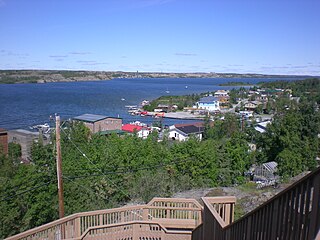
Yellowknife is the capital, largest community, and only city in the Northwest Territories, Canada. It is on the northern shore of Great Slave Lake, about 400 km (250 mi) south of the Arctic Circle, on the west side of Yellowknife Bay near the outlet of the Yellowknife River.

Pond Inlet is a small, predominantly Inuit community in the Qikiqtaaluk Region of Nunavut, Canada, located on northern Baffin Island. To the Inuit the name of the place "is and always has been Mittimatalik." The Scottish explorer Sir John Ross had named an arm of the sea that separates Bylot Island from Baffin Island as Pond's Bay, and the hamlet now shares that name. On 29 August 1921, the Hudson's Bay Company opened its trading post near the Inuit camp and named it Pond Inlet, marking the expansion of its trading empire into the High Arctic.

Rankin Inlet is an Inuit hamlet on the Kudlulik Peninsula in Nunavut, Canada. It is the largest hamlet and second-largest settlement in Nunavut, after the territorial capital, Iqaluit. On the northwestern Hudson Bay, between Chesterfield Inlet and Arviat, it is the regional centre for the Kivalliq Region.

Kitikmeot Region is an administrative region of Nunavut, Canada. It consists of the southern and eastern parts of Victoria Island with the adjacent part of the mainland as far as the Boothia Peninsula, together with King William Island and the southern portion of Prince of Wales Island. The regional centre is Cambridge Bay.

The Diavik Diamond Mine is a diamond mine in the North Slave Region of the Northwest Territories, Canada, about 300 km (190 mi) northeast of Yellowknife.
Bathurst Inlet, officially Kiluhiqtuq, is a deep inlet located along the northern coast of the Canadian mainland, at the east end of Coronation Gulf, into which the Burnside and Western rivers empty. The name, or its native equivalent Kingoak, is also used to identify the community of Bathurst Inlet located on the shore. Melville Sound opens into the eastern side of the inlet at Cape Croker, west of the Hurd Islands.

Xstrata plc was an Anglo-Swiss multinational mining company headquartered in Zug, Switzerland and with its registered office in London, United Kingdom. It was a major producer of coal, copper, nickel, primary vanadium and zinc and the world's largest producer of ferrochrome. It had operations in 19 countries across Africa, Asia, Australasia, Europe, North America and South America.
Umingmaktok is a now abandoned settlement located in Bathurst Inlet in the Kitikmeot of the Canadian territory of Nunavut. The community was previously known as Bay Chimo and the Inuit refer to the community as Umingmaktuuq.

Bathurst Inlet,, is a small Inuit community located in Bathurst Inlet in the Kitikmeot Region of Nunavut, Canada.

The Jericho Diamond Mine is a dormant diamond mine located in Canada's Nunavut territory. Jericho is Nunavut’s first and only diamond mine. It is located 420 km (260 mi) northeast of Yellowknife, Northwest Territories and is accessible by air all year and by winter road from Yellowknife. The project was mined from 2006 to 2008, and produced 780,000 carats of diamonds from 1,200,000 tonnes of kimberlite mined from the open pit operation. Over $200 million was invested in the development of the Jericho operations including the construction of a 2,000 t per day diamond recovery plant, maintenance facility, fuel farm, and offices and accommodation for 225 personnel.

Canadian diamonds are diamonds which have been mined in any one of the Provinces and territories of Canada. Diamond-rich areas weren't commercially extracted in Canada until the early 1990s. For the first 60 years of the 20th century, diamonds originated from kimberlite pipes and alluvial deposits in places such as Africa and some from South America. Later, diamond discoveries were made in the Soviet Union. Since the 1990s, major diamond discoveries were made and mining operations began. Canadian diamonds play a large role in the world market of diamonds.

Nunavut is the largest and northernmost territory of Canada. It was separated officially from the Northwest Territories on April 1, 1999, via the Nunavut Act and the Nunavut Land Claims Agreement Act, which provided this territory to the Inuit for independent government. The boundaries had been drawn in 1993. The creation of Nunavut resulted in the first major change to Canada's political map in half a century since the province of Newfoundland was admitted in 1949.
Glencore plc is a Swiss multinational commodity trading and mining company with headquarters in Baar, Switzerland. Glencore's oil and gas head office is in London and its registered office is in Saint Helier, Jersey. The current company was created through a merger of Glencore with Xstrata on 2 May 2013. As of 2015, it ranked tenth in the Fortune Global 500 list of the world's largest companies. In the 2020 Forbes Global 2000, Glencore International was ranked as the 484th-largest public company in the world. As of July 2022, it is the world's largest commodity trader.
Contwoyto Lake is a lake in the Kitikmeot Region of the Canadian territory of Nunavut, located near the border with the Northwest Territories. With a total area of 957 km2 (369 sq mi), it is the territories' tenth largest lake.
Arctic Co-operatives Limited is a cooperative federation owned and controlled by 32 community-based cooperative business enterprises located in Nunavut, Northwest Territories, Yukon and northern Manitoba, Canada. Arctic Co-ops coordinates resources, consolidates the purchasing power and provides operational and technical support to the community-based co-operatives to enable them to provide a wide range of services to their local member-owners. Arctic Co-ops operates in both English and Inuktitut and provides patronage dividends to the local members.

Milne Inlet is a small, shallow arm of Eclipse Sound which, along with Navy Board Inlet, separates Bylot Island from Baffin Island in Nunavut's Qikiqtaaluk Region. Milne Inlet flows in a southerly direction from Navy Board Inlet at the confluence of Eclipse Sound. Milne Inlet is shallow and has high tides and strong winds. It only has 90 days where it is ice-free—from August to October. The hamlet of Mittimatalik —Pond Inlet which is 92% Inuit, is the gateway to many tourist attractions in the region, and is 80 km from Milne Inlet. The region is part of the Arctic Cordillera, with one of Canada's most inhospitable climates—with long, dark winters and temperatures averaging −35 °C (−31 °F).
The Mary River Mine is an open pit iron ore mine on Inuit Owned Land (IOL) operated by the Baffinland Iron Mines Corporation (BIMC), in the Mary River area of the Qikiqtaaluk Region, on Baffin Island, Nunavut, in the Canadian Arctic Archipelago. As of 2021, Mary River mine operation consists of an open-pit mine, two work camps for hundreds of workers, a tote road—from the Mary River site to Milne Inlet—and a port infrastructure at Milne Inlet. According to a 4-year study published in 2008, the Mary River Mine, with its four massive iron ore deposits of 65-70% pure iron ore was "one of the most promising undeveloped iron deposits on the planet". It was not until technological advances were in place in 2010, and the market for iron ore had dramatically increased that sizable financial backing for the high cost of development in a remote region known for its inhospitable climate, was available. The mine began operations in 2014, and the first shipment to Europe arrived in 2015. Baffinland is currently planning on expanding the mine. In February 2021, a group of Inuit hunters blockaded access to the mine for a week to protest the expansion.
This timeline of Yellowknife history summarises key events in the history of Yellowknife, a city in the Northwest Territories, Canada.
